Went to the Auckland Waterfront Forum yesterday. Four presentations: Feedback from Waterfront Development Agency "Masterplan" consultation; Wynyard Quarter Public Space Project; Queens Wharf Development; and Westhaven. Very interesting. Then questions. Major concerns emerged from the floor. Not well handled from the front. Hence this open letter....
Dear Bob,
You're not going to like this letter but you like robust feedback. One of the things I liked about the way you got the meeting going was when you spoke directly to Alex Swney and told him you respected what he was doing with 'Heart of the City'. You reflected and said, "we don't care enough about enough in this city..."
And I liked the breakfast. Man that Bircher Muesli was the best I've had in ages. And great idea to serve it in those fancy cocktail glasses. Must've cost an arm and a leg though. Thought we were on a budget....
Enjoyed Brenna's feedback presentation. I can imagine how much effort went into smoothing out the wrinkles. You clearly liked the fact that 83% of the feedback was positive. Well. The public like what they see on Wynyard - and most were duped by the glossy images in the coffee table publication you put out. A few of us understood enough, saw behind the pictures enough, and cared enough, to put in submissions of concern about the 1989 Port-Expansion plans that were buried in there and the hasty Cruise-on-Queens plans. These concerns did get a mention from Brenna.
What also got a mention was the Peer Review you had done by Arup Australia of your Waterfront Development Plan consultation process. This has to be a must-read. I saw there in the fine print of Brenna's presentation on screen that you guys got a 'tick' for heritage and stuff, but you got a 'cross' for environment and leadership. That must've come as a bit of a shock to the Board.
After Brenna we had Henry Crother's excellent work on Wynyard's public spaces. And then Queens Wharf by staff member John Smith who I remember well from my time at Auckland Regional Council. Then Westhaven. And then questions. And statements.
It was pretty much sitting room only in the Floating Pavillion which had gently rocked us all throughout. Not to the point the Bircher Muesli was threatened, but a few of us were a bit seasick.
Jasmax Principal, Richard Harris made the ballsiest statement. It was ballsy because Jasmax have been retained to do the Queens Wharf Shed 10 Cruise Ship Terminal design. You hardly every hear from contractors, or would-be contractors, in an environment like that. Don't bite the hand that feeds you. But these are the guys who know their onions. And they care. But there is a sort of misplaced code of ethics that shuts most of them up - just when you really need to hear from them. So we heard you Richard. Richard said loud and clear that the Waterfront Masterplan was not an Integrated Plan - because it had not properly considered the Port Expansion plans. His was a leadership statement.
I hope you heard what Richard said, Bob. Really heard. Because if you didn't you're in the wrong job.
Greg McKeown also asked you a question, Bob. But you didn't really answer it. Greg started by saying he was heartened by your sympathetic words recognising public concerns about the Port plans, but that he couldn't quite reconcile those words with the technical papers and policy positions on your website. I don't think you heard what Greg was saying. He is always polite. Or maybe you decided to smile and move on. But you're not a man averse to a down-trou, so I'll say it plain. You're being two-faced about the Port, Bob. Is that your Board's position too?
There is that big Arup 'X' against your leadership....
To be fair, Bob, you did describe the Port as 'the elephant in the room...'
But the Port isn't the only elephant.
In Brenna's presentation the Waterfront Forum was advised that Queens Wharf Cruise Ship terminal Resource Consents would be 'granted in July 2012'. I used my question to ask John Smith what consents were being applied for, what the process would be, and whether the applications would be notified.
John told the meeting that discussions were occurring with Council staff, and that he would get back to me when he had more information.
I have to tell you Bob, that I was somewhat disappointed to hear this. You praise the planning work that delivered what we see at Wynyard. You probably know that Auckland City Council and Auckland Regional Council sweated blood over the plan changes and resource consent applications and public hearings that hammered out the planning framework for what we see today. So John's answer to my question should concern you and your Board. It's shonky.
Bit like that stormwater pipe in Glen Eden. Shonky.
You guys are planning a major change in the use of Queens Wharf (Cruise Ship Terminal), with a whole pile of different environmental effects (traffic on Quay Street, passengers in buses and taxis, conflicts with public access - all different from before), without going through due process.
Would you allow a private developer to do what you plan to do with Queens Wharf without a decent set of resource consents and conditions?
Auckland Council is the other elephant that was in the room yesterday. The biggest elephant in fact.
Show your board and Auckland some leadership Bob. Then we'll give you a 'TICK'.
Showing posts with label waterfront development agency. Show all posts
Showing posts with label waterfront development agency. Show all posts
Friday, February 24, 2012
Tuesday, October 18, 2011
Port Plans Will Cut Views
|
Does it matter? Yes it does.... |
|
|
|
|
|
|
If you want to protect Queens Wharf so it can be used as Queens Park (not a cruise ship park), then you need to put in a submission about that too. |


Sunday, October 16, 2011
Wynyard Quarter Playground Con Job
|
|
|
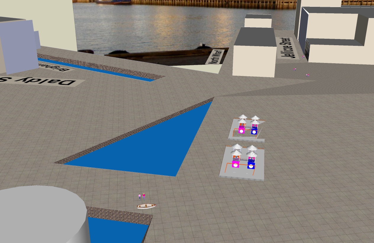
By the way, in the bottom left of the image you can see the top of a cement silo. Which is around about where the Waterfront Development Plan photo was taken from... |
|
The other new building is the "cheese wedge" to the left, along Wynyard Wharf. This is planned to be 5 stories high and is intended to be a residential development block. |
This image gives an idea of the urban canyon design that is planned for Jellicoe Street. (Love the open space feel it now has - while you can.) |
|
The purpose of my computer generated impression is to convey a sense of the urban design that is actually planned for Jellicoe when all of the anticipated building development is complete. It is not a park at all. A far cry from what you see now, and from the misleading impression in the photographs used in the Waterfront Development Plan. Why? You might think. Well. The Waterfront Development Plan as it stands is like a coffee table prospectus for future investors in Wynyard Quarter. They will love the pictures of smiling people. Future customers for their future developments. It's a brochure for investors rather than genuine consultation. I think the kind of public confusion that these images cause, can lead to a false sense of comfort, a false feeling that - at last - Council is taking seriously public calls for quality waterfront public space. It is also why I am concerned that the same sort of private development overcrowding will occur elsewhere on Auckland's waterfront (as it did on Princes Wharf). I had hoped for a more honest communication from Waterfront Development Agency. It does not augur well for what is planned behind closed doors for Queens Wharf. |



Tuesday, September 6, 2011
Auckland Waterfront Plan Conflict
Transformational Move 8 -
Revitalising the Waterfront -
Water City...
This is the heading for the part of the Auckland CBD MasterPlan draft (voted on by Auckland Council at its Future Vision Ctte meeying on August 31st) that deals with the waterfront.
Interesting that this is given advance airing on this agenda. Before the Waterfront Development Agency has said much publicly. Or released its own draft plan. A sign perhaps that Auckland Council is tightening its control of its CCOs. Apart from Watercare.... Not necessarily a sign of conflict. But certainly a sign of control...
I have looked through the various documents to discern the Council's logic and vision for Queens Wharf. And this is what I have found out so far, in the proposed plans, which are being put out for public consultation later this month:
That Queens Wharf is to become part of what is termed the "cruise hub" terminal for New Zealand for the "next 15 years".... This will require "the redevelopment of Shed 10, supported by the Cloud structure together with a secondary terminal at Princes Wharf". Apparently this: "cruise terminal project (2012-2018) will deliver a world-class, multi-cruise terminal on Queens Wharf..."
The numbers used to support this use of Queens Wharf are hard to find. But one is quoted in the report to councillors. It states: "each year 2.5 million visitors arrive in Auckland by air or cruise ship...the challenge is to make them stay longer...".
And then there are the various visions and goals and outcomes in the CBD Masterplan. It appears that the Waterfront Development Agency have set four goals in its statement of intent, which it appears is being put out for consultation, but buried in the detail of Auckland Council's CBD Master Plan. The WDA wants this:
But what's really interesting is that Auckland Council has taken these goals, and used them to assess its "cruise hub" plan for Queens Wharf. They come to this conclusion:

Revitalising the Waterfront -
Water City...
This is the heading for the part of the Auckland CBD MasterPlan draft (voted on by Auckland Council at its Future Vision Ctte meeying on August 31st) that deals with the waterfront.
Interesting that this is given advance airing on this agenda. Before the Waterfront Development Agency has said much publicly. Or released its own draft plan. A sign perhaps that Auckland Council is tightening its control of its CCOs. Apart from Watercare.... Not necessarily a sign of conflict. But certainly a sign of control...
I have looked through the various documents to discern the Council's logic and vision for Queens Wharf. And this is what I have found out so far, in the proposed plans, which are being put out for public consultation later this month:
That Queens Wharf is to become part of what is termed the "cruise hub" terminal for New Zealand for the "next 15 years".... This will require "the redevelopment of Shed 10, supported by the Cloud structure together with a secondary terminal at Princes Wharf". Apparently this: "cruise terminal project (2012-2018) will deliver a world-class, multi-cruise terminal on Queens Wharf..."
Comment: The fine print here suggests that the Cloud will stay for 15 years. The fine print also indicates it is planned that the Queens Wharf cruise terminal is planned for at least 2 cruise ships at a time (multi-ship). While the words "cruise hub" don't say "hubbing terminal", that is the clear inference.
Both of these plans seriously threaten the public use of, and access to, Queens Wharf. I find them completely out of place on a people's waterfront.
The numbers used to support this use of Queens Wharf are hard to find. But one is quoted in the report to councillors. It states: "each year 2.5 million visitors arrive in Auckland by air or cruise ship...the challenge is to make them stay longer...".
Comment: We know Auckland is a tourist gateway. And it's good to retain the tourism dollar in Auckland. But Auckland is also home to 1.5 million locals. And it would be good to retain some of their visitor dollars in Auckland also - and one way to do that - as we are belatedly discovering at Wynyard Quarter - is provide high quality, full of activities, waterfront public spaces and places.
But if you really believed Auckland's economic salvation from the visitor economy was tourists, and if you get really picky, even naive, you might think it's better to drop those unsuspecting tourists as close to Queens Street as you can get them. Queens Wharf is closer than Auckland International Airport after all. But how many passengers are we talking about here, and how much do they spend while they are here - compared to Auckland's 1.5 million residents for example?
If you take a guess, and estimate 60 cruise ship visits with 1000 passengers each, and they seem to stay for 36 hours on average, that boils down to 90,000 visitor days a year. From cruise ship visits. And that's why the Council's quoted figure of "2.5 million" cruise ship and jet plane visitors each year is so misleading. Why? Well let me explain. For example, according to ShareChat's website on the performance of Auckland International airport, "Overall inbound tourism for the twelve months ended February 28 was up 2.5% to 2.5 million". Doesn't leave much room for cruise ship visitors does it? You can see from those two figures that the proportion of visitors coming by cruise ship is tiny - infinitesimal in fact. So this hardly justifies sacrificing a second central city wharf to their activities.
All Auckland would be doing would be providing free-parking for Carnival Australia CEO Ann Sherry's cruise ships. At great cost to Aucklanders.
And then there are the various visions and goals and outcomes in the CBD Masterplan. It appears that the Waterfront Development Agency have set four goals in its statement of intent, which it appears is being put out for consultation, but buried in the detail of Auckland Council's CBD Master Plan. The WDA wants this:
* A public waterfront: A place for all Aucklanders and visitors to Auckland, a destination that is recognised for its outstanding design and architecture, natural environmental quality, public spaces, facilities and events; a place where we can express our cultural heritage and history, and celebrate our great achievements as a city and nation.
* A working waterfront: a place for marine industries and businesses, local and international port activities; an attractor of further high value business investment and activity, the location that supports authentic and gritty waterfront activities that must locate here.
* A growing waterfront: The critical location of sustainable urban transformation and renewal in Auckland, where we must demonstrate international best practice and innovation; achieve a significant lift in Auckland’s and NZ’s productivity; the most liveable of New Zealand’s central city urban communities; a vibrant mix of residents, business and employees, visitors, and activities.
* A connected waterfront: A place where people are highly connected locally and with the inner city, to the rest of Auckland and New Zealand; that is highly accessible and safe for pedestrians, cyclists, and passengers, with telecommunications that support connectivity.
Comment: I quite liked these. Well. Apart from the "A growing waterfront" one. Strange words. Calls to mind a doubling of POAL reclamation. You know. Heaps more containers. It's about growth. rather than development. So not really good for the "S" word. The sustainability word. But I love the top one. That's about a public waterfront first (for all Aucklanders and visitors to Auckland - fantastic - love those words), and a working waterfront second.
But what's really interesting is that Auckland Council has taken these goals, and used them to assess its "cruise hub" plan for Queens Wharf. They come to this conclusion:
Man oh man. Auckland Councillors actually voted for this. They seriously believe that a multi-ship hubbing cruise ship terminal on Queens Wharf is going to: "enhance public access to, and enjoyment of, Queens Wharf...", and thereby deliver on the Waterfront Development Agency's vision. Think again guys.
And again. Have you done the cost benefit analysis? Have you really weighed the social costs against the economic benefits (remember the tiny numbers) so that you put your hands up and say, yes, we genuinely believe, that a multi-ship hubbing cruise ship terminal on Queens Wharf: "enhances the waterfront as a visitor and waterfront destination, resulting in economic benefits..."
Because that's what you voted for. You voted to double, maybe even triple, central cruise-ship parking places in the heart of Auckland. Thankfully you are consulting over it. Wonder what the WDA thinks about this?
What is it about cruise ships?
Talk about being taken for a ride.
Subscribe to:
Posts (Atom)
Showing posts with label waterfront development agency. Show all posts
Showing posts with label waterfront development agency. Show all posts
Friday, February 24, 2012
Auckland Waterfront Lacks Leadership
Went to the Auckland Waterfront Forum yesterday. Four presentations: Feedback from Waterfront Development Agency "Masterplan" consultation; Wynyard Quarter Public Space Project; Queens Wharf Development; and Westhaven. Very interesting. Then questions. Major concerns emerged from the floor. Not well handled from the front. Hence this open letter....
Dear Bob,
You're not going to like this letter but you like robust feedback. One of the things I liked about the way you got the meeting going was when you spoke directly to Alex Swney and told him you respected what he was doing with 'Heart of the City'. You reflected and said, "we don't care enough about enough in this city..."
And I liked the breakfast. Man that Bircher Muesli was the best I've had in ages. And great idea to serve it in those fancy cocktail glasses. Must've cost an arm and a leg though. Thought we were on a budget....
Enjoyed Brenna's feedback presentation. I can imagine how much effort went into smoothing out the wrinkles. You clearly liked the fact that 83% of the feedback was positive. Well. The public like what they see on Wynyard - and most were duped by the glossy images in the coffee table publication you put out. A few of us understood enough, saw behind the pictures enough, and cared enough, to put in submissions of concern about the 1989 Port-Expansion plans that were buried in there and the hasty Cruise-on-Queens plans. These concerns did get a mention from Brenna.
What also got a mention was the Peer Review you had done by Arup Australia of your Waterfront Development Plan consultation process. This has to be a must-read. I saw there in the fine print of Brenna's presentation on screen that you guys got a 'tick' for heritage and stuff, but you got a 'cross' for environment and leadership. That must've come as a bit of a shock to the Board.
After Brenna we had Henry Crother's excellent work on Wynyard's public spaces. And then Queens Wharf by staff member John Smith who I remember well from my time at Auckland Regional Council. Then Westhaven. And then questions. And statements.
It was pretty much sitting room only in the Floating Pavillion which had gently rocked us all throughout. Not to the point the Bircher Muesli was threatened, but a few of us were a bit seasick.
Jasmax Principal, Richard Harris made the ballsiest statement. It was ballsy because Jasmax have been retained to do the Queens Wharf Shed 10 Cruise Ship Terminal design. You hardly every hear from contractors, or would-be contractors, in an environment like that. Don't bite the hand that feeds you. But these are the guys who know their onions. And they care. But there is a sort of misplaced code of ethics that shuts most of them up - just when you really need to hear from them. So we heard you Richard. Richard said loud and clear that the Waterfront Masterplan was not an Integrated Plan - because it had not properly considered the Port Expansion plans. His was a leadership statement.
I hope you heard what Richard said, Bob. Really heard. Because if you didn't you're in the wrong job.
Greg McKeown also asked you a question, Bob. But you didn't really answer it. Greg started by saying he was heartened by your sympathetic words recognising public concerns about the Port plans, but that he couldn't quite reconcile those words with the technical papers and policy positions on your website. I don't think you heard what Greg was saying. He is always polite. Or maybe you decided to smile and move on. But you're not a man averse to a down-trou, so I'll say it plain. You're being two-faced about the Port, Bob. Is that your Board's position too?
There is that big Arup 'X' against your leadership....
To be fair, Bob, you did describe the Port as 'the elephant in the room...'
But the Port isn't the only elephant.
In Brenna's presentation the Waterfront Forum was advised that Queens Wharf Cruise Ship terminal Resource Consents would be 'granted in July 2012'. I used my question to ask John Smith what consents were being applied for, what the process would be, and whether the applications would be notified.
John told the meeting that discussions were occurring with Council staff, and that he would get back to me when he had more information.
I have to tell you Bob, that I was somewhat disappointed to hear this. You praise the planning work that delivered what we see at Wynyard. You probably know that Auckland City Council and Auckland Regional Council sweated blood over the plan changes and resource consent applications and public hearings that hammered out the planning framework for what we see today. So John's answer to my question should concern you and your Board. It's shonky.
Bit like that stormwater pipe in Glen Eden. Shonky.
You guys are planning a major change in the use of Queens Wharf (Cruise Ship Terminal), with a whole pile of different environmental effects (traffic on Quay Street, passengers in buses and taxis, conflicts with public access - all different from before), without going through due process.
Would you allow a private developer to do what you plan to do with Queens Wharf without a decent set of resource consents and conditions?
Auckland Council is the other elephant that was in the room yesterday. The biggest elephant in fact.
Show your board and Auckland some leadership Bob. Then we'll give you a 'TICK'.
Dear Bob,
You're not going to like this letter but you like robust feedback. One of the things I liked about the way you got the meeting going was when you spoke directly to Alex Swney and told him you respected what he was doing with 'Heart of the City'. You reflected and said, "we don't care enough about enough in this city..."
And I liked the breakfast. Man that Bircher Muesli was the best I've had in ages. And great idea to serve it in those fancy cocktail glasses. Must've cost an arm and a leg though. Thought we were on a budget....
Enjoyed Brenna's feedback presentation. I can imagine how much effort went into smoothing out the wrinkles. You clearly liked the fact that 83% of the feedback was positive. Well. The public like what they see on Wynyard - and most were duped by the glossy images in the coffee table publication you put out. A few of us understood enough, saw behind the pictures enough, and cared enough, to put in submissions of concern about the 1989 Port-Expansion plans that were buried in there and the hasty Cruise-on-Queens plans. These concerns did get a mention from Brenna.
What also got a mention was the Peer Review you had done by Arup Australia of your Waterfront Development Plan consultation process. This has to be a must-read. I saw there in the fine print of Brenna's presentation on screen that you guys got a 'tick' for heritage and stuff, but you got a 'cross' for environment and leadership. That must've come as a bit of a shock to the Board.
After Brenna we had Henry Crother's excellent work on Wynyard's public spaces. And then Queens Wharf by staff member John Smith who I remember well from my time at Auckland Regional Council. Then Westhaven. And then questions. And statements.
It was pretty much sitting room only in the Floating Pavillion which had gently rocked us all throughout. Not to the point the Bircher Muesli was threatened, but a few of us were a bit seasick.
Jasmax Principal, Richard Harris made the ballsiest statement. It was ballsy because Jasmax have been retained to do the Queens Wharf Shed 10 Cruise Ship Terminal design. You hardly every hear from contractors, or would-be contractors, in an environment like that. Don't bite the hand that feeds you. But these are the guys who know their onions. And they care. But there is a sort of misplaced code of ethics that shuts most of them up - just when you really need to hear from them. So we heard you Richard. Richard said loud and clear that the Waterfront Masterplan was not an Integrated Plan - because it had not properly considered the Port Expansion plans. His was a leadership statement.
I hope you heard what Richard said, Bob. Really heard. Because if you didn't you're in the wrong job.
Greg McKeown also asked you a question, Bob. But you didn't really answer it. Greg started by saying he was heartened by your sympathetic words recognising public concerns about the Port plans, but that he couldn't quite reconcile those words with the technical papers and policy positions on your website. I don't think you heard what Greg was saying. He is always polite. Or maybe you decided to smile and move on. But you're not a man averse to a down-trou, so I'll say it plain. You're being two-faced about the Port, Bob. Is that your Board's position too?
There is that big Arup 'X' against your leadership....
To be fair, Bob, you did describe the Port as 'the elephant in the room...'
But the Port isn't the only elephant.
In Brenna's presentation the Waterfront Forum was advised that Queens Wharf Cruise Ship terminal Resource Consents would be 'granted in July 2012'. I used my question to ask John Smith what consents were being applied for, what the process would be, and whether the applications would be notified.
John told the meeting that discussions were occurring with Council staff, and that he would get back to me when he had more information.
I have to tell you Bob, that I was somewhat disappointed to hear this. You praise the planning work that delivered what we see at Wynyard. You probably know that Auckland City Council and Auckland Regional Council sweated blood over the plan changes and resource consent applications and public hearings that hammered out the planning framework for what we see today. So John's answer to my question should concern you and your Board. It's shonky.
Bit like that stormwater pipe in Glen Eden. Shonky.
You guys are planning a major change in the use of Queens Wharf (Cruise Ship Terminal), with a whole pile of different environmental effects (traffic on Quay Street, passengers in buses and taxis, conflicts with public access - all different from before), without going through due process.
Would you allow a private developer to do what you plan to do with Queens Wharf without a decent set of resource consents and conditions?
Auckland Council is the other elephant that was in the room yesterday. The biggest elephant in fact.
Show your board and Auckland some leadership Bob. Then we'll give you a 'TICK'.
Tuesday, October 18, 2011
Port Plans Will Cut Views
|
Does it matter? Yes it does.... |
|
|
|
|
|
|
If you want to protect Queens Wharf so it can be used as Queens Park (not a cruise ship park), then you need to put in a submission about that too. |
Sunday, October 16, 2011
Wynyard Quarter Playground Con Job
|
|
|
By the way, in the bottom left of the image you can see the top of a cement silo. Which is around about where the Waterfront Development Plan photo was taken from... |
|
The other new building is the "cheese wedge" to the left, along Wynyard Wharf. This is planned to be 5 stories high and is intended to be a residential development block. |
This image gives an idea of the urban canyon design that is planned for Jellicoe Street. (Love the open space feel it now has - while you can.) |
|
The purpose of my computer generated impression is to convey a sense of the urban design that is actually planned for Jellicoe when all of the anticipated building development is complete. It is not a park at all. A far cry from what you see now, and from the misleading impression in the photographs used in the Waterfront Development Plan. Why? You might think. Well. The Waterfront Development Plan as it stands is like a coffee table prospectus for future investors in Wynyard Quarter. They will love the pictures of smiling people. Future customers for their future developments. It's a brochure for investors rather than genuine consultation. I think the kind of public confusion that these images cause, can lead to a false sense of comfort, a false feeling that - at last - Council is taking seriously public calls for quality waterfront public space. It is also why I am concerned that the same sort of private development overcrowding will occur elsewhere on Auckland's waterfront (as it did on Princes Wharf). I had hoped for a more honest communication from Waterfront Development Agency. It does not augur well for what is planned behind closed doors for Queens Wharf. |
Tuesday, September 6, 2011
Auckland Waterfront Plan Conflict
Transformational Move 8 -
Revitalising the Waterfront -
Water City...
This is the heading for the part of the Auckland CBD MasterPlan draft (voted on by Auckland Council at its Future Vision Ctte meeying on August 31st) that deals with the waterfront.
Interesting that this is given advance airing on this agenda. Before the Waterfront Development Agency has said much publicly. Or released its own draft plan. A sign perhaps that Auckland Council is tightening its control of its CCOs. Apart from Watercare.... Not necessarily a sign of conflict. But certainly a sign of control...
I have looked through the various documents to discern the Council's logic and vision for Queens Wharf. And this is what I have found out so far, in the proposed plans, which are being put out for public consultation later this month:
That Queens Wharf is to become part of what is termed the "cruise hub" terminal for New Zealand for the "next 15 years".... This will require "the redevelopment of Shed 10, supported by the Cloud structure together with a secondary terminal at Princes Wharf". Apparently this: "cruise terminal project (2012-2018) will deliver a world-class, multi-cruise terminal on Queens Wharf..."
The numbers used to support this use of Queens Wharf are hard to find. But one is quoted in the report to councillors. It states: "each year 2.5 million visitors arrive in Auckland by air or cruise ship...the challenge is to make them stay longer...".
And then there are the various visions and goals and outcomes in the CBD Masterplan. It appears that the Waterfront Development Agency have set four goals in its statement of intent, which it appears is being put out for consultation, but buried in the detail of Auckland Council's CBD Master Plan. The WDA wants this:
But what's really interesting is that Auckland Council has taken these goals, and used them to assess its "cruise hub" plan for Queens Wharf. They come to this conclusion:
Revitalising the Waterfront -
Water City...
This is the heading for the part of the Auckland CBD MasterPlan draft (voted on by Auckland Council at its Future Vision Ctte meeying on August 31st) that deals with the waterfront.
Interesting that this is given advance airing on this agenda. Before the Waterfront Development Agency has said much publicly. Or released its own draft plan. A sign perhaps that Auckland Council is tightening its control of its CCOs. Apart from Watercare.... Not necessarily a sign of conflict. But certainly a sign of control...
I have looked through the various documents to discern the Council's logic and vision for Queens Wharf. And this is what I have found out so far, in the proposed plans, which are being put out for public consultation later this month:
That Queens Wharf is to become part of what is termed the "cruise hub" terminal for New Zealand for the "next 15 years".... This will require "the redevelopment of Shed 10, supported by the Cloud structure together with a secondary terminal at Princes Wharf". Apparently this: "cruise terminal project (2012-2018) will deliver a world-class, multi-cruise terminal on Queens Wharf..."
Comment: The fine print here suggests that the Cloud will stay for 15 years. The fine print also indicates it is planned that the Queens Wharf cruise terminal is planned for at least 2 cruise ships at a time (multi-ship). While the words "cruise hub" don't say "hubbing terminal", that is the clear inference.
Both of these plans seriously threaten the public use of, and access to, Queens Wharf. I find them completely out of place on a people's waterfront.
The numbers used to support this use of Queens Wharf are hard to find. But one is quoted in the report to councillors. It states: "each year 2.5 million visitors arrive in Auckland by air or cruise ship...the challenge is to make them stay longer...".
Comment: We know Auckland is a tourist gateway. And it's good to retain the tourism dollar in Auckland. But Auckland is also home to 1.5 million locals. And it would be good to retain some of their visitor dollars in Auckland also - and one way to do that - as we are belatedly discovering at Wynyard Quarter - is provide high quality, full of activities, waterfront public spaces and places.
But if you really believed Auckland's economic salvation from the visitor economy was tourists, and if you get really picky, even naive, you might think it's better to drop those unsuspecting tourists as close to Queens Street as you can get them. Queens Wharf is closer than Auckland International Airport after all. But how many passengers are we talking about here, and how much do they spend while they are here - compared to Auckland's 1.5 million residents for example?
If you take a guess, and estimate 60 cruise ship visits with 1000 passengers each, and they seem to stay for 36 hours on average, that boils down to 90,000 visitor days a year. From cruise ship visits. And that's why the Council's quoted figure of "2.5 million" cruise ship and jet plane visitors each year is so misleading. Why? Well let me explain. For example, according to ShareChat's website on the performance of Auckland International airport, "Overall inbound tourism for the twelve months ended February 28 was up 2.5% to 2.5 million". Doesn't leave much room for cruise ship visitors does it? You can see from those two figures that the proportion of visitors coming by cruise ship is tiny - infinitesimal in fact. So this hardly justifies sacrificing a second central city wharf to their activities.
All Auckland would be doing would be providing free-parking for Carnival Australia CEO Ann Sherry's cruise ships. At great cost to Aucklanders.
And then there are the various visions and goals and outcomes in the CBD Masterplan. It appears that the Waterfront Development Agency have set four goals in its statement of intent, which it appears is being put out for consultation, but buried in the detail of Auckland Council's CBD Master Plan. The WDA wants this:
* A public waterfront: A place for all Aucklanders and visitors to Auckland, a destination that is recognised for its outstanding design and architecture, natural environmental quality, public spaces, facilities and events; a place where we can express our cultural heritage and history, and celebrate our great achievements as a city and nation.
* A working waterfront: a place for marine industries and businesses, local and international port activities; an attractor of further high value business investment and activity, the location that supports authentic and gritty waterfront activities that must locate here.
* A growing waterfront: The critical location of sustainable urban transformation and renewal in Auckland, where we must demonstrate international best practice and innovation; achieve a significant lift in Auckland’s and NZ’s productivity; the most liveable of New Zealand’s central city urban communities; a vibrant mix of residents, business and employees, visitors, and activities.
* A connected waterfront: A place where people are highly connected locally and with the inner city, to the rest of Auckland and New Zealand; that is highly accessible and safe for pedestrians, cyclists, and passengers, with telecommunications that support connectivity.
Comment: I quite liked these. Well. Apart from the "A growing waterfront" one. Strange words. Calls to mind a doubling of POAL reclamation. You know. Heaps more containers. It's about growth. rather than development. So not really good for the "S" word. The sustainability word. But I love the top one. That's about a public waterfront first (for all Aucklanders and visitors to Auckland - fantastic - love those words), and a working waterfront second.
But what's really interesting is that Auckland Council has taken these goals, and used them to assess its "cruise hub" plan for Queens Wharf. They come to this conclusion:
Man oh man. Auckland Councillors actually voted for this. They seriously believe that a multi-ship hubbing cruise ship terminal on Queens Wharf is going to: "enhance public access to, and enjoyment of, Queens Wharf...", and thereby deliver on the Waterfront Development Agency's vision. Think again guys.
And again. Have you done the cost benefit analysis? Have you really weighed the social costs against the economic benefits (remember the tiny numbers) so that you put your hands up and say, yes, we genuinely believe, that a multi-ship hubbing cruise ship terminal on Queens Wharf: "enhances the waterfront as a visitor and waterfront destination, resulting in economic benefits..."
Because that's what you voted for. You voted to double, maybe even triple, central cruise-ship parking places in the heart of Auckland. Thankfully you are consulting over it. Wonder what the WDA thinks about this?
What is it about cruise ships?
Talk about being taken for a ride.
Subscribe to:
Posts (Atom)




