Showing posts with label North Wharf. Show all posts

Sunday, October 16, 2011

Wynyard Quarter Playground Con Job


This picture features prominently in the Auckland Council Waterfront Development Plan. I think it was taken from the top of one of the cement silos. Great picture. Symbolises all that the public have come to love about the Wynyard Quarter. It is called Silo Park after all. So it feels like a park, the section with seating and cildren's playground and wide open spaces. It feels like a park because no-one's near enough to ask you for money. But....

As Heart of the City have highlighted in their public campaign: it's a con. The very popular open spaces that make up the children's playground and other delightful public spaces today are planned for buildings tomorrow. Not public spaces....

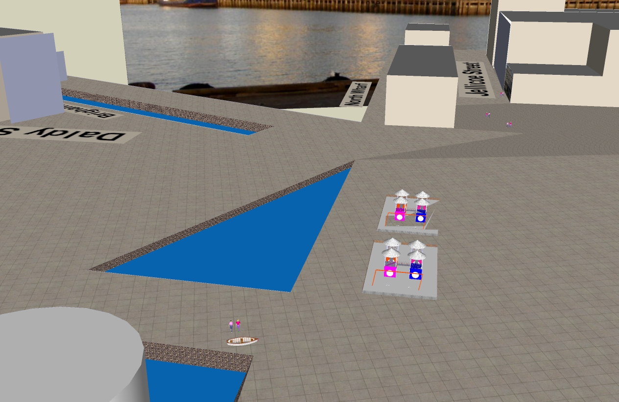
I produced this image from a computer model of the proposed Wynyard Quarter development. I made it while serving as an ARC Councillor a few years ago to get a better picture of what was planned. I've put a children's playground in here - around about where it is today. You will see there is a lot of empty space in the graphic - like you see today. You can see the two buildings that have been built on North Wharf on either side of the NetShed (which is hidden between them). You can also see Sanford's fish restaurant which is beside the modelled ASB tower building that's going up now...

All that's changed in this graphic is that I've taken away the children's playground from the model. I've taken it away because it won't be there when the development that has been planned goes ahead. The next few images show what is planned for this part of Wynyard Quarter over the next decade or so....

So here's the "mixed use" building planned for the site of the children's playground and the sandy area. The building will be about 5 stories high....


By the way, in the bottom left of the image you can see the top of a cement silo. Which is around about where the Waterfront Development Plan photo was taken from...

Anothern five storey building is planned along the Jellicoe Street alignment. It will run close to the silos as you can see in this picture. It will complete the northern wall of buildings along the northern side of Jellicoe Street.

Two buildings have been added here. A five storey mixed use building on the left side of the Sanford's Restaurant is provided for in the plans. This building will be almost as high as the section of the ASB building on the other side (RHS) of Sanfords. You can get an idea from this image how tiny the Sanfords building will look compared to its new modern neighbours. (I wasn't the only one worried by the lack of heritage respect.)


The other new building is the "cheese wedge" to the left, along Wynyard Wharf. This is planned to be 5 stories high and is intended to be a residential development block.

This image shows the rest of the planned development along the southern edge of Jellicoe. Building heights range from 5 to 8 (I think) stories high. Mostly mixed use. Some activation at Jellicoe Street level.


This image gives an idea of the urban canyon design that is planned for Jellicoe Street. (Love the open space feel it now has - while you can.)

This image shows the rest of the planned development approximately in alignment with the gantry structure that has been erected. These buildings are planned to house a mix of commercial and light industrial uses and will be built on sites presently occupied by some of the storage tanks.

TEXT

This image gives an impression of what you will see from a lower elevation, looking along Jellicoe at about the 3rd storey. (NB: At the end of Jellicoe there is the walking bridge which is not shown in this graphic.)


The purpose of my computer generated impression is to convey a sense of the urban design that is actually planned for Jellicoe when all of the anticipated building development is complete. It is not a park at all. A far cry from what you see now, and from the misleading impression in the photographs used in the Waterfront Development Plan. Why? You might think. Well. The Waterfront Development Plan as it stands is like a coffee table prospectus for future investors in Wynyard Quarter. They will love the pictures of smiling people. Future customers for their future developments. It's a brochure for investors rather than genuine consultation.

I think the kind of public confusion that these images cause, can lead to a false sense of comfort, a false feeling that - at last - Council is taking seriously public calls for quality waterfront public space.


It is also why I am concerned that the same sort of private development overcrowding will occur elsewhere on Auckland's waterfront (as it did on Princes Wharf). I had hoped for a more honest communication from Waterfront Development Agency. It does not augur well for what is planned behind closed doors for Queens Wharf.

Monday, May 23, 2011

Western Reclamation Transformation Apace

The Western Reclamation transformation work is proceeding at break-neck speed. The direction for this was largely determined before Auckland Council arose from the abolition of Auckland City Council and Auckland Regional Council. It has been implemented by Sea + City, which has been rebranded and bits added to form the Waterfront Development Agency (WDA). This posting is a step in time - a few weeks ago - as development has unfolded. Starting at the South Eastern end, this is where steps down to the water are being formed. This picture shows the temporary sea wall built to keep the sea at bay while steps are hewn out of the reclamation...

Near the steps is the rapidly developing Marine Event Centre. This was Auckland City Council's baby. Looking at it now you wonder about the need for the McCully Cloud on Queens Wharf. It's a pretty high spec building. Great you would think for exhibitions when there are not marine events being run out of it (like the Volvo Round the World and such like...)

The Marine Event Centre looks pretty good close up too. High spec. I haven't even been inside it yet. Shows - I suppose - what sort of gap existed between Auckland City Council and Auckland Regional Council...

This is one of my favourite bits of the transformation. This is North Wharf - looking South East. Detailed pavement work is being carried out here, but the old rail sidings remain...

This is a wider shot of North Wharf looking South East. You can see the Net Shed building to the right. It has been restored to a very high standard. It is still recogniseable as a corrugated iron shed. That's good. It will be interesting to see how the Net Shed gets used....


Stepping through the Net Shed, and turning round to look North West along Jellicoe Street. See how wide it is. Room for substantial street tree planting. Wide pedestrian pavements. You can see Sanfords here, Net Shed to the right. Remember that the ASB Building - and ancillary parking buildings etc, with sky walk between - is to be built beside Sanfords....

This is another favourite for me. The Six Pack Cement silos. Lots of character here...

And a lot of silo detail has been retained. This will be highly valued as time passes. Good call...

Then we get to the small wharf and harbour complex at the North Western end of Jellicoe Street. It's being reclaimed so boats can easily come and go. It's a great space because of the wharves that almost encircle the water space... so much potential. This is where I saw (in my vision for this place) a lot of character and heritage boats being moored....

...but I think there is a real risk of this space being lost to big yachts and commercial boat parking... This would be another great Auckland tragedy of the commons. We are so good at letting go of what is of great public value and potential, and letting commercial interests get title and rights. Short-term boat parking and moorage fees call the tune. When really - this place could be of enormous public interest - a sort of heritage destination anchor at the end of Jellicoe. This is why we have one Auckland Council. If there is a genuine interest in maritime heritage at Auckland Council (not just lip service) - make sure this space is not commercialised.

Showing posts with label North Wharf. Show all posts

Sunday, October 16, 2011

Wynyard Quarter Playground Con Job

This picture features prominently in the Auckland Council Waterfront Development Plan. I think it was taken from the top of one of the cement silos. Great picture. Symbolises all that the public have come to love about the Wynyard Quarter. It is called Silo Park after all. So it feels like a park, the section with seating and cildren's playground and wide open spaces. It feels like a park because no-one's near enough to ask you for money. But....

As Heart of the City have highlighted in their public campaign: it's a con. The very popular open spaces that make up the children's playground and other delightful public spaces today are planned for buildings tomorrow. Not public spaces....

I produced this image from a computer model of the proposed Wynyard Quarter development. I made it while serving as an ARC Councillor a few years ago to get a better picture of what was planned. I've put a children's playground in here - around about where it is today. You will see there is a lot of empty space in the graphic - like you see today. You can see the two buildings that have been built on North Wharf on either side of the NetShed (which is hidden between them). You can also see Sanford's fish restaurant which is beside the modelled ASB tower building that's going up now...

All that's changed in this graphic is that I've taken away the children's playground from the model. I've taken it away because it won't be there when the development that has been planned goes ahead. The next few images show what is planned for this part of Wynyard Quarter over the next decade or so....

So here's the "mixed use" building planned for the site of the children's playground and the sandy area. The building will be about 5 stories high....


By the way, in the bottom left of the image you can see the top of a cement silo. Which is around about where the Waterfront Development Plan photo was taken from...

Anothern five storey building is planned along the Jellicoe Street alignment. It will run close to the silos as you can see in this picture. It will complete the northern wall of buildings along the northern side of Jellicoe Street.

Two buildings have been added here. A five storey mixed use building on the left side of the Sanford's Restaurant is provided for in the plans. This building will be almost as high as the section of the ASB building on the other side (RHS) of Sanfords. You can get an idea from this image how tiny the Sanfords building will look compared to its new modern neighbours. (I wasn't the only one worried by the lack of heritage respect.)


The other new building is the "cheese wedge" to the left, along Wynyard Wharf. This is planned to be 5 stories high and is intended to be a residential development block.

This image shows the rest of the planned development along the southern edge of Jellicoe. Building heights range from 5 to 8 (I think) stories high. Mostly mixed use. Some activation at Jellicoe Street level.


This image gives an idea of the urban canyon design that is planned for Jellicoe Street. (Love the open space feel it now has - while you can.)

This image shows the rest of the planned development approximately in alignment with the gantry structure that has been erected. These buildings are planned to house a mix of commercial and light industrial uses and will be built on sites presently occupied by some of the storage tanks.

TEXT

This image gives an impression of what you will see from a lower elevation, looking along Jellicoe at about the 3rd storey. (NB: At the end of Jellicoe there is the walking bridge which is not shown in this graphic.)


The purpose of my computer generated impression is to convey a sense of the urban design that is actually planned for Jellicoe when all of the anticipated building development is complete. It is not a park at all. A far cry from what you see now, and from the misleading impression in the photographs used in the Waterfront Development Plan. Why? You might think. Well. The Waterfront Development Plan as it stands is like a coffee table prospectus for future investors in Wynyard Quarter. They will love the pictures of smiling people. Future customers for their future developments. It's a brochure for investors rather than genuine consultation.

I think the kind of public confusion that these images cause, can lead to a false sense of comfort, a false feeling that - at last - Council is taking seriously public calls for quality waterfront public space.


It is also why I am concerned that the same sort of private development overcrowding will occur elsewhere on Auckland's waterfront (as it did on Princes Wharf). I had hoped for a more honest communication from Waterfront Development Agency. It does not augur well for what is planned behind closed doors for Queens Wharf.

Monday, May 23, 2011

Western Reclamation Transformation Apace

The Western Reclamation transformation work is proceeding at break-neck speed. The direction for this was largely determined before Auckland Council arose from the abolition of Auckland City Council and Auckland Regional Council. It has been implemented by Sea + City, which has been rebranded and bits added to form the Waterfront Development Agency (WDA). This posting is a step in time - a few weeks ago - as development has unfolded. Starting at the South Eastern end, this is where steps down to the water are being formed. This picture shows the temporary sea wall built to keep the sea at bay while steps are hewn out of the reclamation...

Near the steps is the rapidly developing Marine Event Centre. This was Auckland City Council's baby. Looking at it now you wonder about the need for the McCully Cloud on Queens Wharf. It's a pretty high spec building. Great you would think for exhibitions when there are not marine events being run out of it (like the Volvo Round the World and such like...)

The Marine Event Centre looks pretty good close up too. High spec. I haven't even been inside it yet. Shows - I suppose - what sort of gap existed between Auckland City Council and Auckland Regional Council...

This is one of my favourite bits of the transformation. This is North Wharf - looking South East. Detailed pavement work is being carried out here, but the old rail sidings remain...

This is a wider shot of North Wharf looking South East. You can see the Net Shed building to the right. It has been restored to a very high standard. It is still recogniseable as a corrugated iron shed. That's good. It will be interesting to see how the Net Shed gets used....


Stepping through the Net Shed, and turning round to look North West along Jellicoe Street. See how wide it is. Room for substantial street tree planting. Wide pedestrian pavements. You can see Sanfords here, Net Shed to the right. Remember that the ASB Building - and ancillary parking buildings etc, with sky walk between - is to be built beside Sanfords....

This is another favourite for me. The Six Pack Cement silos. Lots of character here...

And a lot of silo detail has been retained. This will be highly valued as time passes. Good call...

Then we get to the small wharf and harbour complex at the North Western end of Jellicoe Street. It's being reclaimed so boats can easily come and go. It's a great space because of the wharves that almost encircle the water space... so much potential. This is where I saw (in my vision for this place) a lot of character and heritage boats being moored....

...but I think there is a real risk of this space being lost to big yachts and commercial boat parking... This would be another great Auckland tragedy of the commons. We are so good at letting go of what is of great public value and potential, and letting commercial interests get title and rights. Short-term boat parking and moorage fees call the tune. When really - this place could be of enormous public interest - a sort of heritage destination anchor at the end of Jellicoe. This is why we have one Auckland Council. If there is a genuine interest in maritime heritage at Auckland Council (not just lip service) - make sure this space is not commercialised.

