Showing posts with label Auckland Architecture Association. Show all posts

Sunday, March 11, 2012

Proper Process on Waterfront

Last week was a big week for Auckland's waterfront. And I'm not talking about the strike. Thanks to a huge amount of work from Heart of the City (Alex Swney and Greg McKeown), the Auckland Architects Association (Adam Mercer), and the Devonport Borough Council (Roger Brittenden and Margot McCrae), and many others behind the scenes, the Auckland Council agreed to review the plans it included in its draft Auckland Plan (the Spatial Plan).

The New Zealand Herald also played its part in bringing about this decision, as is evident from the way it reported Council's change of plan.

I was pleased by the fact NZ Herald ran an opinion piece I wrote challenging the Mayor's notion of what constituted proper process on the waterfront, and because this is my blog, I'll quote it here:
Due Process on the Waterfront

Auckland Council’s Mayor has tried to reassure the public that any expansion of Auckland’s port will: “go through proper processes and be fully debated by council and public…” (NZ Herald, Feb 28). Mayor Brown is reported as saying: “…increased container traffic might create demand for new berths and this will be dealt with at the time by the resource consent process.”

I fear that Mayor Brown’s faith in Resource Management Act processes to deal with matters of public interest on Auckland’s waterfront raises questions about his Council’s commitment to planning compliance, and about what proper processes are.

Legislation establishing the Auckland Council required it to prepare and adopt a spatial plan to provide a long term strategy for Auckland. This is a different approach to planning. The spatial plan’s objectives have to refer to the social, economic, environmental and economic realms to align it with the four well-beings referred to in the Local Government Act 2002, and to broaden the purpose of the spatial plan so that it is not simply about growth and development.

Auckland Council has prepared a draft spatial plan which is out for consultation now. Public concern has arisen because Council’s spatial plan documents all incorporate – without question or serious consideration of alternative options - Port expansion plans which assume a 400% growth in container volumes and 18 hectares further development of Waitemata Harbour through reclamation.

Concern has arisen because the Waterfront Development Agency (WDA) which is the Council controlled organisation responsible for preparing Auckland’s Waterfront Masterplan – a central component of the Auckland Spatial Plan - restricted its consideration to exclude Port of Auckland Ltd (POAL) and its expansion plans. The WDA’s Masterplan for Auckland’s waterfront concentrates on the assets that it owns. These exclude Port assets which are ‘managed and operated’ by Auckland Council Investments Ltd (ACIL) – another council controlled organisation. Its statement of intent says ACIL, ‘will endeavour to develop and implement a long-term strategy for POAL which seeks to improve POAL’s productivity.’ It also states that ACIL, ‘will identify and resolve potential conflicts between POAL’s operational requirements and other waterfront activities and plans of strategic significance to the region.’

Mayor Brown is an optimist, and that’s a good thing, but he’s dreaming if he believes that a Waitemata Harbour resource consent process is the right place to resolve the policy conflicts that inevitably exist between this proliferation of organisations, let alone with public interest considerations.

The buck clearly stops with Auckland Council when it comes to the adoption of a spatial plan for Auckland. By law, the Auckland Spatial Plan must, ‘enable coherent and co-ordinated decision making by the Auckland Council and other parties to determine the future location and timing of critical infrastructure.’ If that isn’t clear enough, the law also states that Auckland Council, ‘must identify the existing and future location of critical infrastructure.’

The spatial plan is intended to set a strategic direction for Auckland and its communities that ‘integrates social, economic, environmental, and cultural objectives’. It is about integrated planning. It is not about a proliferation of separate plans - one for the Port, one for the rest of the waterfront, and one for the downtown city. That’s what Auckland had before amalgamation.

And if 20 hectares of new reclamation is not ‘critical infrastructure’ I don’t know what is. The Port Expansion Plans need to be in the spatial plan – or not – after due process. Not put in the ‘too hard’ basket and left for some future Council to deal with by applying for a resource consent.

The Resource Management Act does have its place in Auckland waterfront planning. Many praise the planning work that delivered what the public love and now enjoy down at the Wynyard Quarter. Auckland City Council and Auckland Regional Council sweated blood over plan changes and resource consent applications and public hearings hammering out the planning framework for what we see today.

That was due process, once fundamental and broad brush decisions had been taken about how the land and water spaces would be used.

It respected matters such as heritage and the public interest in, and enjoyment of Auckland’s waterfront.

Unlike the way Auckland Council is handling waterfront development right now. Under Mayor Brown’s leadership, Auckland Council is planning a major change in the use of Queens Wharf (Auckland’s Primary Cruise Ship Terminal), which has a raft of environmental effects (traffic on Quay Street, passengers in buses and taxis, conflicts with public access and ferry traffic, engineering work on a heritage building), apparently without going through due process.

Last week I was advised that no decision had been made to publicly notify any consents for the development of Queens Wharf.

No responsible Council would allow a private developer to do what Auckland Council and its ‘council-controlled organisations’ plan to do with Queens Wharf. Not without a decent set of resource consents and conditions.

It’s good to talk about ‘proper process’, now it’s time to walk the talk on the waterfront.
Behind the scenes there are those who say, "but the Spatial Plan has no statutory force...." almost as an excuse to defend the use of the resource consent process as the best way forward. However, as the Council officer advised the council during its meeting, any resource consent application must "have regard to any other matter the consent authority considers relevant and reasonably necessary to determine the application..."

The Auckland Spatial Plan - which is a statutory requirement - and which has been consulted extensively - might be regarded as having "no statutory force" by some - black letter of the law types. But it must be a relevant matter, otherwise why have one at all?

A major requirement for the idea of a spatial plan is to enable Auckland to plan for what it wants in future. The Resource Management Act has a purpose to avoid adverse effects. We need that. But we also need a plan that sets out a future. And that plan needs to include an agreed plan for the Port. The old Port expansion plans of 1989 need to be reviewed in the light of new thinking in 2012.

Sunday, April 25, 2010

Queens Wharf Opens on Anzac Day


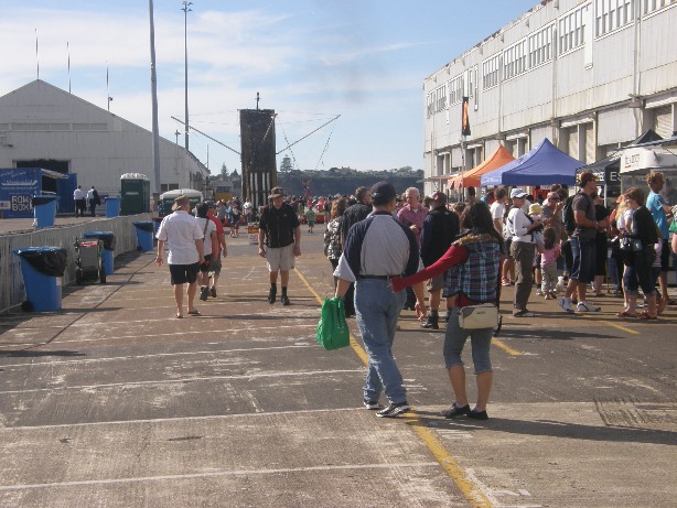
What fantastic weather there was for the public opening of Queens Wharf as a "Peoples' Wharf" by ARC Chairman Mike Lee and Minister of Rugby World Cup Murray McCully.


Despite little advertising the wharf was thronging with people. Where did they all come from? Hard to say. Just came down town after Anzac Day looking for something to do, and saw there was something up at Queens Wharf Party Central and headed on down.


Vintage vehicles, games, bouncy castles, take away food, the odd portaloo. Shade was hard to find though. In all that sun...


And the Ports had laid on their party special. Everyone came down to the end of the wharf to look...


Yep. Dancing tugboats. Something for everybody.


They came on their bikes, disability buggies, wheel chairs, skate boards, and they came in their hundreds taking photos and enjoying being somewhere they'd never been allowed before...


And they came to have a look inside those sheds. Both sheds were open to view. Pity nobody could look in the upper floor of Shed 10 - but it's not that safe at the moment...


Many people took the opportunity to have a good look around. See what they could see. Not everybody can see the potential. That's par for the course. It's only after some love, design and attention to detail that the sheds will be able to come into their own...


The temporary ceiling is there, now, with strip lighting - fairly institutional - for when Shed 10 is used as cruise ship terminal which happens at the moment when Princes Wharf has a cruise ship.


The guy in the yellow T Shirt is from the Auckland Architecture Association. He was one of a dozen people from the Association at the opening, handing out a leaflet -

SOS Queens Wharf

Save Our Sheds

Sign their petition at: http://www.sosqueenswharf.co.nz/

TV was interested in the view of architects about the sheds. Their leaflet reads: "...so as you walk around this place of our history ask yourself, is today the day we wash away our reminders of yesteryear? Is today the day to sign the destruction of our choices? Is today the day we should be dismantling our heritage? Once it's gone we can't get it back..."

Go to Facebook, and check out their page: SOS Queens Wharf


The big attraction on the day was undoubtedly the Navy. Their ship attracted huge amounts of attention. Everybody wanted to be shown around.


It got tiring in the sun. There are quite a few old timbers around to sit on, and the sheds were great shelter from the sun.


These big timbers make great seats. And they all seem to be in the right place.


As I sailed back to Devonport in the ferry, it was great to look back and see people on the peoples' wharf. Walking around the sheds. Enjoying their newest Regional Park. It was a great step of ARC and Government to buy this wharf and everything upon it.


It's no longer a restricted area that we have to keep out of. Too much emphasis on a future cruise ship terminal could shut this place down again - as the security demands and worries about risk - force the big fence to be locked and the gates clanged shut.

We need to think hard before doing anything permanent that will detract from the promise and the potential of the "peoples' wharf"....

Showing posts with label Auckland Architecture Association. Show all posts

Sunday, March 11, 2012

Proper Process on Waterfront

Last week was a big week for Auckland's waterfront. And I'm not talking about the strike. Thanks to a huge amount of work from Heart of the City (Alex Swney and Greg McKeown), the Auckland Architects Association (Adam Mercer), and the Devonport Borough Council (Roger Brittenden and Margot McCrae), and many others behind the scenes, the Auckland Council agreed to review the plans it included in its draft Auckland Plan (the Spatial Plan).

The New Zealand Herald also played its part in bringing about this decision, as is evident from the way it reported Council's change of plan.

I was pleased by the fact NZ Herald ran an opinion piece I wrote challenging the Mayor's notion of what constituted proper process on the waterfront, and because this is my blog, I'll quote it here:
Due Process on the Waterfront

Auckland Council’s Mayor has tried to reassure the public that any expansion of Auckland’s port will: “go through proper processes and be fully debated by council and public…” (NZ Herald, Feb 28). Mayor Brown is reported as saying: “…increased container traffic might create demand for new berths and this will be dealt with at the time by the resource consent process.”

I fear that Mayor Brown’s faith in Resource Management Act processes to deal with matters of public interest on Auckland’s waterfront raises questions about his Council’s commitment to planning compliance, and about what proper processes are.

Legislation establishing the Auckland Council required it to prepare and adopt a spatial plan to provide a long term strategy for Auckland. This is a different approach to planning. The spatial plan’s objectives have to refer to the social, economic, environmental and economic realms to align it with the four well-beings referred to in the Local Government Act 2002, and to broaden the purpose of the spatial plan so that it is not simply about growth and development.

Auckland Council has prepared a draft spatial plan which is out for consultation now. Public concern has arisen because Council’s spatial plan documents all incorporate – without question or serious consideration of alternative options - Port expansion plans which assume a 400% growth in container volumes and 18 hectares further development of Waitemata Harbour through reclamation.

Concern has arisen because the Waterfront Development Agency (WDA) which is the Council controlled organisation responsible for preparing Auckland’s Waterfront Masterplan – a central component of the Auckland Spatial Plan - restricted its consideration to exclude Port of Auckland Ltd (POAL) and its expansion plans. The WDA’s Masterplan for Auckland’s waterfront concentrates on the assets that it owns. These exclude Port assets which are ‘managed and operated’ by Auckland Council Investments Ltd (ACIL) – another council controlled organisation. Its statement of intent says ACIL, ‘will endeavour to develop and implement a long-term strategy for POAL which seeks to improve POAL’s productivity.’ It also states that ACIL, ‘will identify and resolve potential conflicts between POAL’s operational requirements and other waterfront activities and plans of strategic significance to the region.’

Mayor Brown is an optimist, and that’s a good thing, but he’s dreaming if he believes that a Waitemata Harbour resource consent process is the right place to resolve the policy conflicts that inevitably exist between this proliferation of organisations, let alone with public interest considerations.

The buck clearly stops with Auckland Council when it comes to the adoption of a spatial plan for Auckland. By law, the Auckland Spatial Plan must, ‘enable coherent and co-ordinated decision making by the Auckland Council and other parties to determine the future location and timing of critical infrastructure.’ If that isn’t clear enough, the law also states that Auckland Council, ‘must identify the existing and future location of critical infrastructure.’

The spatial plan is intended to set a strategic direction for Auckland and its communities that ‘integrates social, economic, environmental, and cultural objectives’. It is about integrated planning. It is not about a proliferation of separate plans - one for the Port, one for the rest of the waterfront, and one for the downtown city. That’s what Auckland had before amalgamation.

And if 20 hectares of new reclamation is not ‘critical infrastructure’ I don’t know what is. The Port Expansion Plans need to be in the spatial plan – or not – after due process. Not put in the ‘too hard’ basket and left for some future Council to deal with by applying for a resource consent.

The Resource Management Act does have its place in Auckland waterfront planning. Many praise the planning work that delivered what the public love and now enjoy down at the Wynyard Quarter. Auckland City Council and Auckland Regional Council sweated blood over plan changes and resource consent applications and public hearings hammering out the planning framework for what we see today.

That was due process, once fundamental and broad brush decisions had been taken about how the land and water spaces would be used.

It respected matters such as heritage and the public interest in, and enjoyment of Auckland’s waterfront.

Unlike the way Auckland Council is handling waterfront development right now. Under Mayor Brown’s leadership, Auckland Council is planning a major change in the use of Queens Wharf (Auckland’s Primary Cruise Ship Terminal), which has a raft of environmental effects (traffic on Quay Street, passengers in buses and taxis, conflicts with public access and ferry traffic, engineering work on a heritage building), apparently without going through due process.

Last week I was advised that no decision had been made to publicly notify any consents for the development of Queens Wharf.

No responsible Council would allow a private developer to do what Auckland Council and its ‘council-controlled organisations’ plan to do with Queens Wharf. Not without a decent set of resource consents and conditions.

It’s good to talk about ‘proper process’, now it’s time to walk the talk on the waterfront.
Behind the scenes there are those who say, "but the Spatial Plan has no statutory force...." almost as an excuse to defend the use of the resource consent process as the best way forward. However, as the Council officer advised the council during its meeting, any resource consent application must "have regard to any other matter the consent authority considers relevant and reasonably necessary to determine the application..."

The Auckland Spatial Plan - which is a statutory requirement - and which has been consulted extensively - might be regarded as having "no statutory force" by some - black letter of the law types. But it must be a relevant matter, otherwise why have one at all?

A major requirement for the idea of a spatial plan is to enable Auckland to plan for what it wants in future. The Resource Management Act has a purpose to avoid adverse effects. We need that. But we also need a plan that sets out a future. And that plan needs to include an agreed plan for the Port. The old Port expansion plans of 1989 need to be reviewed in the light of new thinking in 2012.

Sunday, April 25, 2010

Queens Wharf Opens on Anzac Day


What fantastic weather there was for the public opening of Queens Wharf as a "Peoples' Wharf" by ARC Chairman Mike Lee and Minister of Rugby World Cup Murray McCully.


Despite little advertising the wharf was thronging with people. Where did they all come from? Hard to say. Just came down town after Anzac Day looking for something to do, and saw there was something up at Queens Wharf Party Central and headed on down.


Vintage vehicles, games, bouncy castles, take away food, the odd portaloo. Shade was hard to find though. In all that sun...


And the Ports had laid on their party special. Everyone came down to the end of the wharf to look...


Yep. Dancing tugboats. Something for everybody.


They came on their bikes, disability buggies, wheel chairs, skate boards, and they came in their hundreds taking photos and enjoying being somewhere they'd never been allowed before...


And they came to have a look inside those sheds. Both sheds were open to view. Pity nobody could look in the upper floor of Shed 10 - but it's not that safe at the moment...


Many people took the opportunity to have a good look around. See what they could see. Not everybody can see the potential. That's par for the course. It's only after some love, design and attention to detail that the sheds will be able to come into their own...


The temporary ceiling is there, now, with strip lighting - fairly institutional - for when Shed 10 is used as cruise ship terminal which happens at the moment when Princes Wharf has a cruise ship.


The guy in the yellow T Shirt is from the Auckland Architecture Association. He was one of a dozen people from the Association at the opening, handing out a leaflet -

SOS Queens Wharf

Save Our Sheds

Sign their petition at: http://www.sosqueenswharf.co.nz/

TV was interested in the view of architects about the sheds. Their leaflet reads: "...so as you walk around this place of our history ask yourself, is today the day we wash away our reminders of yesteryear? Is today the day to sign the destruction of our choices? Is today the day we should be dismantling our heritage? Once it's gone we can't get it back..."

Go to Facebook, and check out their page: SOS Queens Wharf


The big attraction on the day was undoubtedly the Navy. Their ship attracted huge amounts of attention. Everybody wanted to be shown around.


It got tiring in the sun. There are quite a few old timbers around to sit on, and the sheds were great shelter from the sun.


These big timbers make great seats. And they all seem to be in the right place.


As I sailed back to Devonport in the ferry, it was great to look back and see people on the peoples' wharf. Walking around the sheds. Enjoying their newest Regional Park. It was a great step of ARC and Government to buy this wharf and everything upon it.


It's no longer a restricted area that we have to keep out of. Too much emphasis on a future cruise ship terminal could shut this place down again - as the security demands and worries about risk - force the big fence to be locked and the gates clanged shut.

We need to think hard before doing anything permanent that will detract from the promise and the potential of the "peoples' wharf"....

