Showing posts with label museum. Show all posts

Friday, December 30, 2011

Parnell to Museum = Steep Walk

If you follow this blog you may have noticed some grumpy postings about the location currently proposed by Auckland Council for a railway station at Parnell. These include: Parnell Pet Project Politics, Parnell Station - Shakespearean Tragedy, Parnell Station - Poor Process Continues.

A big part of the justification cited for the location is that it affords easy access to the Museum, despite the fact the location is in the cleft of a steep gully. As this sequence of images illustrates. To the left is a walk many of you may have taken in the heart of Auckland. It's from Kitchener Street (top of Victoria), up a paved walkway and steps, to the flagpole on Albert Park. From A to B. You can check the physical elevations of these points using Google Earth. The elevation of A is 99 feet, while that of B is 131 feet, which indicates you climb 32 feet vertically in that walk. Which I know leaves people I know puffed taking this walk on the way to Maidment Theatre from the car park.

This aerial shows a walk I take quite a bit when I'm walking to University from the ferry. From Custom St East, up Emily Place, through Emily Park to the bottom of Princes Street, and then up to Waterloo Quadrant, and so on. The elevations are as follows: A is 39 feet, B is 69 feet, c is 97 feet, and D is 131 feet. I get a bit puffed doing this walk briskly - and I'm cycling fit. Do the math and you see that the vertical climb, from A to D is 92 feet.
This shows the proposed location for Parnell Station (Point A), and a possible route up to the Museum. As far as I know, no budget has yet been allocated for this path and/or steps. It needs to go through some native bush. The elevation of proposed Parnell Station is 62 feet. The elevation of Point B is 163 feet, of Point C is 191 feet, and a slight incline from there up to the museum at Point D at 200 feet.

The whole climb is 138 feet, and there is very steep climb out of the gully of more than 100 feet. This might be a walk in the park for some - but it does not constitute easy and convenient access to the museum. It certainly does not justify building a railway station at this location.

Friday, June 11, 2010

Navy Adapts Heritage Sheds


This is a great little story and I am proud to share it with greater Auckland. This is a view of North Head Devonport, from Mt Victoria. You can see the old military base buildings on North Head - now occupied by DOC. Dept of Conservation.

Looking closer, down by the water, you can see the Navy land at Torpedo Bay. That's the refurbished Torpedo Wharf.

And even closer you can see two shed like buildings on the waterfront, overlooked by residential buildings - many of them heritage villas.

This is the larger of the two sheds, and will soon open as the Navy Museum. I understand the opening of the museum is sometime in October this year. You can see Mt Victoria in the background.

The shed has been reclad in corrugated iron, but retains many of its features. The original shed was built over a hundred years ago, and was an important part of the harbour's defences against seaborn invasion.


This view of the shed frontage shows a modern style entry area has been designed for public entry and also to house a sea view cafe.

The windows are original - old drawings of the original shed showed these windows in this position. A heritage architect was retained by the Navy to get the detail as right as they could for their tight budget of less than $1.5 million for the whole job.

Inside the entry is the white reception and interpretation area. The original ironwork supporting the roof is a feature.


The main part of the museum is in sharp dark contrast. Again the original roof structure is evident. When first built this area was where the mines were assembled before being put in position across the harbour entrance.

The wooden structures are being added later - within the shed envelope - to house the Navy's collection of exhibits and museum displays.


Again, this dark space is lined with the original doors that led to the areas where the mines and explosives were stored.

There are 3 mine and explosive storage areas. These have the highest historic values I understand, and their restoration will be more detailed and painstaking. You can see on the floor the original rail tracks used for the trollies that carried the mines and their makings into the assembly area.

This picture shows the roof, which is curved, around 2 feet thick of concrete, which was poured into shape and supported by rail-lines structures that you can see in the ceiling.

The doorways, windows and walls are around 2 feet thick concrete also. Designed to withstand a significant explosion.

The explosives storage areas fit against the cliff with its coastal pohutakawa. Creating interesting spaces for education and coffee away from the wind.


The whole area has many interesting places to sit and explore. Whereever possible the design has incorporated the old and original woodwork and corrugated iron work and concrete.

Somehow it all blends into the surrounding Devonport landscape.

And here's the other shed, which sits alongside Torpedo Wharf.

It's an old structure too, needed some serious love and attention.

It was the Boat Shed at Torpedo Bay.


And inside it's a magic place.

Well done Navy.

You've shown Auckland what can be done within a tight budget, working with the Historic Places Trust, to adaptively reuse your old sheds.

Fantastic.

Showing posts with label museum. Show all posts

Friday, December 30, 2011

Parnell to Museum = Steep Walk

If you follow this blog you may have noticed some grumpy postings about the location currently proposed by Auckland Council for a railway station at Parnell. These include: Parnell Pet Project Politics, Parnell Station - Shakespearean Tragedy, Parnell Station - Poor Process Continues.

A big part of the justification cited for the location is that it affords easy access to the Museum, despite the fact the location is in the cleft of a steep gully. As this sequence of images illustrates. To the left is a walk many of you may have taken in the heart of Auckland. It's from Kitchener Street (top of Victoria), up a paved walkway and steps, to the flagpole on Albert Park. From A to B. You can check the physical elevations of these points using Google Earth. The elevation of A is 99 feet, while that of B is 131 feet, which indicates you climb 32 feet vertically in that walk. Which I know leaves people I know puffed taking this walk on the way to Maidment Theatre from the car park.

This aerial shows a walk I take quite a bit when I'm walking to University from the ferry. From Custom St East, up Emily Place, through Emily Park to the bottom of Princes Street, and then up to Waterloo Quadrant, and so on. The elevations are as follows: A is 39 feet, B is 69 feet, c is 97 feet, and D is 131 feet. I get a bit puffed doing this walk briskly - and I'm cycling fit. Do the math and you see that the vertical climb, from A to D is 92 feet.
This shows the proposed location for Parnell Station (Point A), and a possible route up to the Museum. As far as I know, no budget has yet been allocated for this path and/or steps. It needs to go through some native bush. The elevation of proposed Parnell Station is 62 feet. The elevation of Point B is 163 feet, of Point C is 191 feet, and a slight incline from there up to the museum at Point D at 200 feet.

The whole climb is 138 feet, and there is very steep climb out of the gully of more than 100 feet. This might be a walk in the park for some - but it does not constitute easy and convenient access to the museum. It certainly does not justify building a railway station at this location.

Friday, June 11, 2010

Navy Adapts Heritage Sheds


This is a great little story and I am proud to share it with greater Auckland. This is a view of North Head Devonport, from Mt Victoria. You can see the old military base buildings on North Head - now occupied by DOC. Dept of Conservation.

Looking closer, down by the water, you can see the Navy land at Torpedo Bay. That's the refurbished Torpedo Wharf.

And even closer you can see two shed like buildings on the waterfront, overlooked by residential buildings - many of them heritage villas.

This is the larger of the two sheds, and will soon open as the Navy Museum. I understand the opening of the museum is sometime in October this year. You can see Mt Victoria in the background.

The shed has been reclad in corrugated iron, but retains many of its features. The original shed was built over a hundred years ago, and was an important part of the harbour's defences against seaborn invasion.
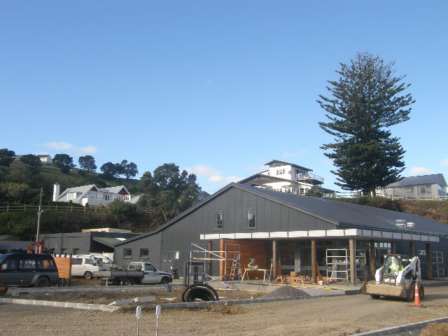

This view of the shed frontage shows a modern style entry area has been designed for public entry and also to house a sea view cafe.

The windows are original - old drawings of the original shed showed these windows in this position. A heritage architect was retained by the Navy to get the detail as right as they could for their tight budget of less than $1.5 million for the whole job.

Inside the entry is the white reception and interpretation area. The original ironwork supporting the roof is a feature.


The main part of the museum is in sharp dark contrast. Again the original roof structure is evident. When first built this area was where the mines were assembled before being put in position across the harbour entrance.

The wooden structures are being added later - within the shed envelope - to house the Navy's collection of exhibits and museum displays.


Again, this dark space is lined with the original doors that led to the areas where the mines and explosives were stored.

There are 3 mine and explosive storage areas. These have the highest historic values I understand, and their restoration will be more detailed and painstaking. You can see on the floor the original rail tracks used for the trollies that carried the mines and their makings into the assembly area.

This picture shows the roof, which is curved, around 2 feet thick of concrete, which was poured into shape and supported by rail-lines structures that you can see in the ceiling.

The doorways, windows and walls are around 2 feet thick concrete also. Designed to withstand a significant explosion.

The explosives storage areas fit against the cliff with its coastal pohutakawa. Creating interesting spaces for education and coffee away from the wind.


The whole area has many interesting places to sit and explore. Whereever possible the design has incorporated the old and original woodwork and corrugated iron work and concrete.

Somehow it all blends into the surrounding Devonport landscape.

And here's the other shed, which sits alongside Torpedo Wharf.

It's an old structure too, needed some serious love and attention.

It was the Boat Shed at Torpedo Bay.


And inside it's a magic place.

Well done Navy.

You've shown Auckland what can be done within a tight budget, working with the Historic Places Trust, to adaptively reuse your old sheds.

Fantastic.

