


|
|
|
|
|
|
|
|
|
|
|
|
|
|
|
|
|
|
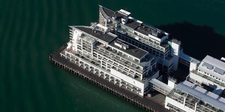 "Where is Auckland Council's Waterfront Masterplan?" is the question I asked nobody in particular as I read NZ Herald's apparently innocuous news item about the sale of the Hilton Hotel on Princes Wharf.
 ".....The five-star boutique Hilton Auckland has been put up for sale in an international campaign but its American operator will continue to run it and the property will stay a Hilton.That made me sit up. The Overseas Passenger Terminal on Princes Wharf is apparently up for sale along with the Hilton Hotel. Makes sense I suppose. One careful owner since 2001. Lock and stock and barrel up for sale.
Dean Humphries, Jones Lang LaSalle Hotels' executive vice-president, who was appointed to sell the property exclusively said Hilton Hotels would manage it for the new owner as part of its operations here, which also include Hiltons at Taupo and Queenstown.
Brian Fitzgerald, an investor, said the property belonged to a number of parties including Willeston Capital.
"It's a great time to sell, never better. You won't sell just because of Rugby World Cup but it's performing well," Fitzgerald said.
Auckland Council records shows the Hilton, at 141 Quay St, was valued at $44.6 million in July 2008.
Its top floor is the quarter-acre apartment of bankrupt property developer David Henderson, whose Kitchener Group developed all six buildings on the wharf, creating bars, restaurants, covered carparking, apartments, offices and the hotel. Henderson still lives in the apartment, despite attempts to sell it for about $10 million.
All the wharf properties are on terminating leases, set to run for another 84 years, so that after then the buildings have no legal right to occupy the wharf space.
Hilton's restaurant White has been shut for some time as it undergoes a refurbishment and is expected to have a new name when it reopens.
Humphries said the ground-floor Overseas Passenger Terminal in the building was part of the sale deal.
Humphries said the ground-floor Overseas Passenger Terminal in the building was part of the sale deal.So. Here we have the agent acting on behalf of the owners, talking up the alternative uses of what we know as Auckland's Overseas Passenger Terminal. So. Auckland didn't get a cinema, or a museum, or much else in the way of public waterfront amenity on Princes Wharf. The cruise ship industry has turned its nose up at the facilities it has had access to and use of for close to a decade. And now it's apparently for sale. So where are they going to go? Read further on in the story...
"This also acts as a conference and exhibition centre for the hotel.
"Auckland Council has indicated that the passenger terminal will move to Queens Wharf in the 2012-13 cruise ship season, which will therefore allow the hotel to utilise this space more efficiently during future cruise ship seasons."
 The caption that ran with this Fonterra story: The dairy industry has a lot to smile about given New Zealand's advantages....
At our annual investor conference last week, one of the presentations was from Fonterra. Feedback from the 600 private client attendees was that this was one of the most interesting talks of the day....
The first point made by Jonathan Mason, Fonterra's chief financial officer, was that New Zealand is a great place for dairy farming, if not the best in the world. The key reason is simple. We have an abundance of water, which makes us great at growing grass and gives us a distinct cost advantage over many countries.
According to Water NZ, New Zealand receives the same amount of rainfall that lands on the entire Australian continent each year, despite Australia being 28 times our size. This ample rainfall underpins New Zealand's position as a low-cost producer of protein.
Our rainfall averages 2m a year, more than double the 0.8m world average.....
The Canterbury Plains themselves have relatively low rainfall and the normally fast-draining characteristics of the soils and rock mean large seasonal fluctuations in the soil moisture content.
Rainfall recharge is therefore critical to maintain groundwater levels and thus the supply of water in these drier areas during spring and summer.
The mean annual rainfall ranges from as little as 300mm in a small area of Central Otago to over 8000mm in the Southern Alps. The average for the whole country is high, but for the greater part lies between 600 and 1500mm. The only areas with average rainfalls under 600mm are found in the South Island to the east of the main ranges, and include most of Central and North Otago, and South Canterbury.
This level of rainfall has a huge bearing on our ability to provide pasture for grazing dairy cows and gives us a strong competitive advantage over other parts of the world that have to supplement their stock with various types of feed, which are usually grain-based. While few local dairy farmers use grain-based supplements, as much as 90 per cent of the rest of the world's dairy cows rely on this, and face its consequently higher cost structure....
Australia and some parts of South America and South Africa operate in a similar way to us, and certain areas in the United States have begun to adopt our model. However, New Zealand still offers a superior environment. We have a stable political landscape and a reputation for safe, high-quality food products in our favour, too....
A co-operative owned by 10,500 farmer shareholders, Fonterra is the world's largest exporter of milk powder, has revenue of $17 billion and operating earnings of $1 billion. It has 432 tankers across 17 depots, operates 86 plants in New Zealand and has the largest milk dryers in the world. It uses 11 New Zealand ports to send 140,000 containers each year to its millions of customers in 140 different countries.
While New Zealand only accounts for about 2 per cent of world dairy production, we export 95 per cent of this. This is in contrast with most other dairy producing nations around the world, where the vast majority is consumed domestically.
Unsurprisingly, China is a key export market, taking nearly a third of Fonterra's milk products last year.... China's growing demand for high-value agricultural products bodes well for New Zealand. The local agricultural sector, blessed as it is with high rainfall, is well placed to benefit from a China that is expected to become a major importer of food....
In addition to the growing demand, water shortages could see China become a major food importer in future. China has only one-third of the freshwater per capita of the global average and, unfortunately, the worst water shortages often coincide with the populous northern region.... As urbanisation continues, a higher proportion of fresh water will be required for residential consumption, further limiting what is available for use in agriculture.
Any land-based venture is not without risk and cyclical ups and downs are to be expected. It should also be noted it does not provide specific exposure to dairy farms or the commodity milk price - rather, it is a manufacturer and marketing company of dairy products. However, the long-term growth potential for Fonterra is enormous.
The purpose of this posting is to report what I have learned about the response of Christchurch Regional Council (Environment Canterbury) and of Christchurch City Council to these warnings, and how they have fulfilled their duties under the Resource Management Act (RMA).every 20 years, an earthquake of Modified Mercalli scale VII can be expected in Christchurch (slight damage in well-constructed buildings; slight to moderate in well-built ordinary structures; much damage in poorly constructed buildings; chimneys broken) and every 55 years an earthquake of Modified Mercalli scale VIII can be expected (Damage is still only slight in structures built to be earthquake-resistant; among substantial ordinary buildings there is much damage and some collapse. Poorly built buildings are substantially damaged. Tall things such as chimneys and monuments collapse. Heavy furniture is overturned).
"Every Regional Council shall have the following functions for the purpose of giving effect to this Act in its region... the control of the use of land for the purpose of.... the avoidance or mitigation of natural hazards...."In Environment Canterbury's (ECan) website we read under a heading: "Earthquake Hazard and Risk Assessment Study" that:
Environment Canterbury needs to know the likely impact and consequences of a major earthquake on Christchurch, to fulfil its hazard mitigation and emergency management functions. Environment Canterbury considers that the earthquake hazard information currently available is generally of a standard and scale suitable for an earthquake risk assessment.This webpage goes on to describe work that was done for ECan by OPUS Consultants in 2005.
A methodology has been developed to undertake an earthquake risk assessment for Christchurch. The approach has been based on generating risk information that meets the objectives of Environment Canterbury and provides a basis for organisations to undertake risk management actions.... An assessment of the risk from earthquakes to Christchurch will assist with the management of the risk, through reduction, readiness, response and recovery planning.Toward the end of the substantial report there are more than 20 recommendations, among which are these:
Environment Canterbury will be commissioning an earthquake risk assessment study for Christchurch. The objectives of such a risk assessment are to understand the likely impact and consequences of a major earthquake on Christchurch, to fulfil its hazard mitigation and emergency management functions, and provide information to stakeholders for them to fulfil their responsibilities under the Civil Defence Emergency Management Act. The following recommendations are made:As far as I can tell, none of these recommendations have been followed up. I repeat the sentence that is set out in ECan's website: "Environment Canterbury considers that the earthquake hazard information currently available is generally of a standard and scale suitable for an earthquake risk assessment." I read that as: don't call us, we'll call you.... But before I move on from that 2005 Opus report, I note some of the information and comments made in the body of the text about the risk of earthquake in Christchurch - based on a literature search:
(i) A risk assessment study be carried out as envisaged to provide information for risk management planning and implementation by Environment Canterbury, and other stakeholders.
vii) Three earthquake scenarios and a possible fourth scenario be used for the risk
assessment, to provide earthquake risk information to enable emergency response
planning for a range of scenarios. The fourth scenario of a hidden Canterbury
Plains Fault earthquake should be discussed with seismologists as part of the risk
assessment, to decide on the appropriateness for this study.
(ix) The liquefaction ground damage map for the Alpine Fault compiled for ECan be
extended to present liquefaction ground damage for earthquake scenarios.
xv) Casualties be assessed based on day time and night time population distributions, based primarily on building damage.
xxiii) The study be carried out based on a robust understanding of the performance of buildings and lifelines in earthquakes and the earthquake hazards affecting
Christchurch.
Beca Carter Hollings & Ferner (2004) report on the outcomes of the Christchurch Liquefaction Study for Environment Canterbury. Liquefaction maps are provided for two groundwater levels, and indicate high, moderate or low liquefaction potential, depending on whether liquefaction is likely in 0.12g, 0.2g or 0.34g earthquake shaking levels. (Ed: Anyone seen these maps?)And then the report gets buried in a morass of conflicting data about ground accelerations and spectral accelerations, and confusion between the effects of local and alpine fault originated earthquakes, but continues to assert "there remains the potential for “hidden” earthquake sources...". The Opus report does not appear to question the earthquake predictions of Elder, but there is much talk in the report of 475 year return period earthquakes and 1000 year return period earthquakes....
The Earthquake Hazard in Christchurch (Elder et al, 1991) presented a detailed evaluation of the earthquake hazards in Christchurch, and contributed to a significant advance in the knowledge of the earthquake hazards in the city. It considered earthquake fault sources, a prediction of the intensity of ground shaking (with associated probabilities and recurrence intervals) ... It also presented some generic comments on the potential damage to buildings and infrastructure. However, this did not provide a formal assessment of the risk....
Risks & Realities, a report of the Christchurch Engineering Lifelines Group (Centre for Advanced Engineering, 1997) presents a multi-disciplinary approach... It discusses three potential sources of earthquakes:
1. Moderately large to large earthquake in the Canterbury Foothills or North Canterbury
2. A very large earthquake on the Alpine Fault
3. Earthquakes centred close to Christchurch
The first two scenarios were considered to be capable of causing MM VIII to IX shaking intensities on the Modified Mercalli Scale, and the third MM VIII intensity.
The lifeline study adopted a 150-year return period earthquake with shaking intensities of MM VIII – IX over most of Christchurch. There was disagreement between researchers as to the expected intensity of shaking in a 150-year return period earthquake....
Chapter 16 Natural Hazards.Sounds like a call for a risk assessment. But wait. There's more to be fair. Regional Policy Statements are required by the RMA to contain: objectives, policies and methods. So here's Objective 1:
Natural hazards in Canterbury can be ranked by the potential damage that could result, for example, taken on an annual basis. Limited information suggests that the most severe regionally significant natural hazards in the region are, in order of importance:
(1) Large magnitude earthquake affecting Christchurch.
(2) Extreme drought.
(3) Waimakariri River flooding of Christchurch and Kaiapoi.
(4) Major tsunami affecting southern Pegasus Bay and Banks Peninsula, or Timaru coastline.
Other natural occurrences of importance include flooding, fire, wind, snowfall, landslip, erosion and sedimentation (including dune build-up), but the relative impact of these, and what degree of management, if any, is warranted, has yet to be determined.
ECan RPS Chapter 16 Objective 1So. The guts of this appears to be that for this policy, earthquakes are not prioritised, but their effects are. (Presumably that would be why a risk assessment was thought to be needed at one time...) And that maybe Christchurch City Council has responsibility - but only if ECan's RPS states they have responsibility.
Avoid or mitigate the actual or potential costs of loss or damage to life, property, or other parts of the environment from natural hazards.
Principal Reasons
Natural hazards can result in loss or damage to people, property, or the environment. The aim of natural hazard management is to minimise the net cost of such damage.
Policy 1
In managing natural hazards, highest priority should be given to the combination of measures which delivers the greatest net benefit.
Explanation
Priority treatment of natural hazards is a policy of dealing first with those that offer the highest return on available investment. This is expressed in terms of protection gained and costs incurred, a notion embodied in the term used above - greatest net benefit. In the calculation of benefit, and of costs, both monetary and non-monetary values are included. Nonmonetary factors include effects on people, cultural values, ecosystems, landscape, and amenity. These values are taken into account by comparing alternative options. Although it is not possible to place a precise dollar value on any improvement in non-monetary benefit, methods are available for gauging whether or not the additional non-monetary benefit exceeds any added monetary cost.
Net benefit, then, is the sum of net monetary benefit, and net non-monetary benefit.
A natural hazard is the interaction or potential interaction between a natural occurrence and something of value to people (ie, assets).... Consistent with this, one natural occurrence may give rise to several natural hazards. A single flood for example, may affect some homes and their occupants, some farmland, a major bridge and an airfield. Each of these interactions is a separate natural hazard. Likewise a single earthquake may affect a main highway and a town.....
For the purposes of this policy, it is these six distinct natural hazards (interactions between a natural occurrence and people and their homes, farmland, a major bridge, airfield, highway and town), not the two hazard triggers (flood and earthquake), that are to be prioritised....
Principal Reasons
Resources for dealing with natural hazards are limited, and it is important to put that investment first in the places where it is likely to do most good.
Methods
1. The methods used or to be used by the Regional Council are:
(b) Regional plans
(d) Information provision
(f) Advocacy, promotion and co-operation
2. District/city councils in the preparation, variation, change, or review of district plans, through the exercise of their functions should, where their responsibilities for natural hazards are stated in this Regional Policy Statement, consider including provisions that:
(a) give highest priority to managing those natural hazards where the greatest net benefit can be delivered.
ECan RPS Chapter 16 Policy 2This is a remarkably convoluted policy. It appears to say that ECan has responsibility, unless its RPS states that Christchurch City Council has responsibility. But it's about as clear as mud to me whether ECan or Christchurch City Council shoulders RMA responsibility for earthquakes in Christchurch City. And then we get to Policy 3.
For the Canterbury region, or any part of the region, which local authority shall have responsibility within its own area for developing objectives, policies, and rules relating to the control of the use of land for the avoidance or mitigation of
natural hazards shall be determined in the following manner:
(a) Particular responsibility for any particular hazard or group of hazards shall initially remain with the local authority or local authorities managing that hazard or group of hazards as at 1 January 1994. Where this responsibility is not clear, the Regional Council shall retain primary responsibility....
Explanation
Natural occurrences that have a potential for adverse effects on people, property, and the environment come in many forms, among them earthquake, tsunami, erosion, landslip, wind, fire, drought, and flooding. Unless the Regional Policy Statement states which local authority or combination of local authorities is responsible for particular natural hazards, the Regional Council retains primary responsibility. Under this policy, the particular responsibility being undertaken initially remains with the local authority or local authorities managing the particular natural hazard at the time the policy was prepared. Subsequent to the Regional
Policy Statement becoming operative, the Regional Council will consult with territorial authorities in the region on any need for a re-allocation of natural hazard responsibilities, and may as a result prepare a change to the Regional Policy Statement.
“Managing” in the context of this policy includes taking particular responsibility for a particular hazard or group of hazards.
It should be noted that under the Building Act 1991, a building consent must be issued by a territorial authority, and that under the RM Act control of the subdivision of land is a function of territorial authorities.
Principal Reasons
To make clear for any particular natural hazard in Canterbury, how it is to be decided which should be dealt with by the Regional Council, and which by city and district councils.
Methods
1. The methods used or to be used by the Regional Council are:
(a) Responsibility for managing natural hazards
(g) Use of other legislation
ECan RPS Chapter 16 Policy 3Ok so this is about precaution. If no hazard management plans or strategies exist "...keep assets away from sources of danger...". This presumes knowledge of the sources of danger.
Where there is no provision for natural hazard in a plan relevant to an area in which an application for a resource consent has been received, the consent authority should, when having regard to this Regional Policy Statement, take a precautionary approach to the potential for a natural hazard to be created or increased as it relates to the applicant or any other person or property. This may be achieved by giving priority to the principle of avoidance.
Explanation
Many natural hazards have yet to be dealt with in plans or strategies, and many others are of such a localised or minor nature that they are never likely to be. The Regional Council and territorial authorities in the region, when considering applications for resource consents must, among other things, consider the possible natural hazard effects of granting such applications. This policy gives priority in those situations to keeping assets away from sources of danger.
CCCDP 3.4 Natural hazardsNothing particularly unexpected there. But the collective ECan and CCC is worrying. Continues the concern that here is an issue that is falling between two Council stools.
Within Christchurch there is risk from a number of natural hazards including:
• possible sea level rises;
• erosion of the coastline and rivers;
• erosion of the Port Hills;
• flooding from the rivers and the coast;
• damage caused by high winds;
• earthquakes; and
• fires in rural areas....
Both the Canterbury Regional Council and Council have responsibilities under the Act for control of the use of land for the avoidance or mitigation of natural hazards. The Regional Council has considerable knowledge about river and coastal processes that give rise to the major natural hazards. The Act requires the Council to hold records of areas subject to natural hazards and has considerable expertise in earthquake standards, flooding and erosion control measures....
CCCDP 3.4.5 Earthquake riskThat all rings fairly true. So what are the objectives, policies and methods for dealing with this issue? Well here they are:
Christchurch lies on the edge of a seismically active region. Consequently, earthquakes are likely to occur at a magnitude which will have major impacts on the City. In addition, there are other areas of active faults close to Christchurch, including Pegasus Bay, Porters Pass, Ashley and Mt Grey, Hope and Lake Heron.
The two main hazards which result from earthquakes are earth deformation (ground surface rupture) and earth shaking (liquefaction, land sliding, ground-cracking, tsunamis).
Strong shaking associated with either a close small magnitude earthquake, or a large magnitude distant event could cause considerable damage to the City, in particular in urban areas.
While single or two storey timber-framed residential dwellings are unlikely to suffer much structural damage in these events, in some areas liquefaction (where the solid ground takes on liquid qualities due to increased pressures) could cause distortion of buildings. Damage to buried cables, water and sewage pipes could also occur.
The most susceptible areas to liquefaction are those with water saturated, loose, well soiled silt and sand. It is also common in peaty soils. Large parts of the eastern suburbs and area around the Heathcote River are underlaid by these materials....
CCCDP 2.5 Objective : Natural hazardsThese words are all good, but little happens on the ground with these sorts of methods unless they are strongly enforced, monitored, and compliance measured. By contrast the methods adopted for flooding (rain - not liquefaction flooding) are extensive. The driver for the difference appears to be that earthquakes "hardly ever happen" (no surprise when you change the return period from 20 years to 475 years), while floods are frequent. Crude cost-benefit calculations complete the policy damage.
To avoid or mitigate the actual or potential adverse effects of loss or damage to life, property, or other parts of the environment from natural hazards.
Reasons
There are a number of potential natural hazards which can affect land within the City. These hazards include the following:
• Flooding from the Waimakariri River, or the river systems within the City, particularly the Heathcote.... etc etc and;
• Seismic activity and liquefaction; etc...
2.5.1 Policy : Presence of natural hazards
To control development within the City to protect life and investment, taking account of the presence of natural hazards and the degree of risk that those hazards impose on the environment.
Explanation and reasons
Natural hazards occur in varying degrees, and may cover greatly different areas.....It is not practicable, either through regulation or other means, to provide total security and protection from natural hazards. The protection of life and investment from natural hazards needs to take into account the likely risks as a result of natural hazards that may affect them. In undertaking measures which may involve intervention in the development or subdivision of land, the Council needs to provide a balance between economic and community needs and any proposals for land use controls, particularly where lower risk and the severity of likely impacts to property is apparent, and mitigation measures are effective and environmentally sound....
2.5.3 Policy : Earthquake
To ensure that buildings are constructed in a manner (or where appropriate, reconstructed) to ensure that their stability in times of earthquake is sufficient to avoid, or at least minimise, loss of life or damage to property.
Explanation and reasons
Christchurch is subject to a reasonably high level of risk from seismic activity and there are limitations to the degree of protection that can be provided from this hazard. However, there are provisions under the Building Act which ensure that new buildings are constructed to a standard which ensures that they have adequate resistance to seismic events. Where appropriate, existing buildings can be upgraded to provide a higher degree of protection. This latter matter has to be balanced however, after taking account of the Council's life safety obligations detailed in the Building Act, with recognition that some buildings would have to be demolished if protection to full earthquake standards were required, as the cost of upgrading would be uneconomic. The Council will in these circumstances take into account the potential land use activities and the risks to life within buildings of this nature, as well as the heritage values of buildings where this is appropriate.
Implementation
Objective 2.5 and associated policies will be implemented through a number of methods including the following...:
• Pattern of zoning that limits development of hazardous areas, e.g. South New Brighton Coastal Hazard Area;
• City rules for Subdivision and Development, including esplanade reserves or strips, and rules for natural and other hazards;
Other methods....:
• Provision of information, e.g. maintenance of information on the extent and location of hazards, (Council's Hazards Register).
• The provisions of the Building Act 2004, such as conditions on building resistance to seismic events.
|
|
|
|
|
|
|
|
|
|
|
|
|
|
|
|
|
|
|
|
|
|
|
|
|
|
|
|
|
|
"Where is Auckland Council's Waterfront Masterplan?" is the question I asked nobody in particular as I read NZ Herald's apparently innocuous news item about the sale of the Hilton Hotel on Princes Wharf. ".....The five-star boutique Hilton Auckland has been put up for sale in an international campaign but its American operator will continue to run it and the property will stay a Hilton.That made me sit up. The Overseas Passenger Terminal on Princes Wharf is apparently up for sale along with the Hilton Hotel. Makes sense I suppose. One careful owner since 2001. Lock and stock and barrel up for sale.
Dean Humphries, Jones Lang LaSalle Hotels' executive vice-president, who was appointed to sell the property exclusively said Hilton Hotels would manage it for the new owner as part of its operations here, which also include Hiltons at Taupo and Queenstown.
Brian Fitzgerald, an investor, said the property belonged to a number of parties including Willeston Capital.
"It's a great time to sell, never better. You won't sell just because of Rugby World Cup but it's performing well," Fitzgerald said.
Auckland Council records shows the Hilton, at 141 Quay St, was valued at $44.6 million in July 2008.
Its top floor is the quarter-acre apartment of bankrupt property developer David Henderson, whose Kitchener Group developed all six buildings on the wharf, creating bars, restaurants, covered carparking, apartments, offices and the hotel. Henderson still lives in the apartment, despite attempts to sell it for about $10 million.
All the wharf properties are on terminating leases, set to run for another 84 years, so that after then the buildings have no legal right to occupy the wharf space.
Hilton's restaurant White has been shut for some time as it undergoes a refurbishment and is expected to have a new name when it reopens.
Humphries said the ground-floor Overseas Passenger Terminal in the building was part of the sale deal.
Humphries said the ground-floor Overseas Passenger Terminal in the building was part of the sale deal.So. Here we have the agent acting on behalf of the owners, talking up the alternative uses of what we know as Auckland's Overseas Passenger Terminal. So. Auckland didn't get a cinema, or a museum, or much else in the way of public waterfront amenity on Princes Wharf. The cruise ship industry has turned its nose up at the facilities it has had access to and use of for close to a decade. And now it's apparently for sale. So where are they going to go? Read further on in the story...
"This also acts as a conference and exhibition centre for the hotel.
"Auckland Council has indicated that the passenger terminal will move to Queens Wharf in the 2012-13 cruise ship season, which will therefore allow the hotel to utilise this space more efficiently during future cruise ship seasons."
The caption that ran with this Fonterra story: The dairy industry has a lot to smile about given New Zealand's advantages....At our annual investor conference last week, one of the presentations was from Fonterra. Feedback from the 600 private client attendees was that this was one of the most interesting talks of the day....
The first point made by Jonathan Mason, Fonterra's chief financial officer, was that New Zealand is a great place for dairy farming, if not the best in the world. The key reason is simple. We have an abundance of water, which makes us great at growing grass and gives us a distinct cost advantage over many countries.
According to Water NZ, New Zealand receives the same amount of rainfall that lands on the entire Australian continent each year, despite Australia being 28 times our size. This ample rainfall underpins New Zealand's position as a low-cost producer of protein.
Our rainfall averages 2m a year, more than double the 0.8m world average.....
The Canterbury Plains themselves have relatively low rainfall and the normally fast-draining characteristics of the soils and rock mean large seasonal fluctuations in the soil moisture content.
Rainfall recharge is therefore critical to maintain groundwater levels and thus the supply of water in these drier areas during spring and summer.
The mean annual rainfall ranges from as little as 300mm in a small area of Central Otago to over 8000mm in the Southern Alps. The average for the whole country is high, but for the greater part lies between 600 and 1500mm. The only areas with average rainfalls under 600mm are found in the South Island to the east of the main ranges, and include most of Central and North Otago, and South Canterbury.
This level of rainfall has a huge bearing on our ability to provide pasture for grazing dairy cows and gives us a strong competitive advantage over other parts of the world that have to supplement their stock with various types of feed, which are usually grain-based. While few local dairy farmers use grain-based supplements, as much as 90 per cent of the rest of the world's dairy cows rely on this, and face its consequently higher cost structure....
Australia and some parts of South America and South Africa operate in a similar way to us, and certain areas in the United States have begun to adopt our model. However, New Zealand still offers a superior environment. We have a stable political landscape and a reputation for safe, high-quality food products in our favour, too....
A co-operative owned by 10,500 farmer shareholders, Fonterra is the world's largest exporter of milk powder, has revenue of $17 billion and operating earnings of $1 billion. It has 432 tankers across 17 depots, operates 86 plants in New Zealand and has the largest milk dryers in the world. It uses 11 New Zealand ports to send 140,000 containers each year to its millions of customers in 140 different countries.
While New Zealand only accounts for about 2 per cent of world dairy production, we export 95 per cent of this. This is in contrast with most other dairy producing nations around the world, where the vast majority is consumed domestically.
Unsurprisingly, China is a key export market, taking nearly a third of Fonterra's milk products last year.... China's growing demand for high-value agricultural products bodes well for New Zealand. The local agricultural sector, blessed as it is with high rainfall, is well placed to benefit from a China that is expected to become a major importer of food....
In addition to the growing demand, water shortages could see China become a major food importer in future. China has only one-third of the freshwater per capita of the global average and, unfortunately, the worst water shortages often coincide with the populous northern region.... As urbanisation continues, a higher proportion of fresh water will be required for residential consumption, further limiting what is available for use in agriculture.
Any land-based venture is not without risk and cyclical ups and downs are to be expected. It should also be noted it does not provide specific exposure to dairy farms or the commodity milk price - rather, it is a manufacturer and marketing company of dairy products. However, the long-term growth potential for Fonterra is enormous.
The purpose of this posting is to report what I have learned about the response of Christchurch Regional Council (Environment Canterbury) and of Christchurch City Council to these warnings, and how they have fulfilled their duties under the Resource Management Act (RMA).every 20 years, an earthquake of Modified Mercalli scale VII can be expected in Christchurch (slight damage in well-constructed buildings; slight to moderate in well-built ordinary structures; much damage in poorly constructed buildings; chimneys broken) and every 55 years an earthquake of Modified Mercalli scale VIII can be expected (Damage is still only slight in structures built to be earthquake-resistant; among substantial ordinary buildings there is much damage and some collapse. Poorly built buildings are substantially damaged. Tall things such as chimneys and monuments collapse. Heavy furniture is overturned).
"Every Regional Council shall have the following functions for the purpose of giving effect to this Act in its region... the control of the use of land for the purpose of.... the avoidance or mitigation of natural hazards...."In Environment Canterbury's (ECan) website we read under a heading: "Earthquake Hazard and Risk Assessment Study" that:
Environment Canterbury needs to know the likely impact and consequences of a major earthquake on Christchurch, to fulfil its hazard mitigation and emergency management functions. Environment Canterbury considers that the earthquake hazard information currently available is generally of a standard and scale suitable for an earthquake risk assessment.This webpage goes on to describe work that was done for ECan by OPUS Consultants in 2005.
A methodology has been developed to undertake an earthquake risk assessment for Christchurch. The approach has been based on generating risk information that meets the objectives of Environment Canterbury and provides a basis for organisations to undertake risk management actions.... An assessment of the risk from earthquakes to Christchurch will assist with the management of the risk, through reduction, readiness, response and recovery planning.Toward the end of the substantial report there are more than 20 recommendations, among which are these:
Environment Canterbury will be commissioning an earthquake risk assessment study for Christchurch. The objectives of such a risk assessment are to understand the likely impact and consequences of a major earthquake on Christchurch, to fulfil its hazard mitigation and emergency management functions, and provide information to stakeholders for them to fulfil their responsibilities under the Civil Defence Emergency Management Act. The following recommendations are made:As far as I can tell, none of these recommendations have been followed up. I repeat the sentence that is set out in ECan's website: "Environment Canterbury considers that the earthquake hazard information currently available is generally of a standard and scale suitable for an earthquake risk assessment." I read that as: don't call us, we'll call you.... But before I move on from that 2005 Opus report, I note some of the information and comments made in the body of the text about the risk of earthquake in Christchurch - based on a literature search:
(i) A risk assessment study be carried out as envisaged to provide information for risk management planning and implementation by Environment Canterbury, and other stakeholders.
vii) Three earthquake scenarios and a possible fourth scenario be used for the risk
assessment, to provide earthquake risk information to enable emergency response
planning for a range of scenarios. The fourth scenario of a hidden Canterbury
Plains Fault earthquake should be discussed with seismologists as part of the risk
assessment, to decide on the appropriateness for this study.
(ix) The liquefaction ground damage map for the Alpine Fault compiled for ECan be
extended to present liquefaction ground damage for earthquake scenarios.
xv) Casualties be assessed based on day time and night time population distributions, based primarily on building damage.
xxiii) The study be carried out based on a robust understanding of the performance of buildings and lifelines in earthquakes and the earthquake hazards affecting
Christchurch.
Beca Carter Hollings & Ferner (2004) report on the outcomes of the Christchurch Liquefaction Study for Environment Canterbury. Liquefaction maps are provided for two groundwater levels, and indicate high, moderate or low liquefaction potential, depending on whether liquefaction is likely in 0.12g, 0.2g or 0.34g earthquake shaking levels. (Ed: Anyone seen these maps?)And then the report gets buried in a morass of conflicting data about ground accelerations and spectral accelerations, and confusion between the effects of local and alpine fault originated earthquakes, but continues to assert "there remains the potential for “hidden” earthquake sources...". The Opus report does not appear to question the earthquake predictions of Elder, but there is much talk in the report of 475 year return period earthquakes and 1000 year return period earthquakes....
The Earthquake Hazard in Christchurch (Elder et al, 1991) presented a detailed evaluation of the earthquake hazards in Christchurch, and contributed to a significant advance in the knowledge of the earthquake hazards in the city. It considered earthquake fault sources, a prediction of the intensity of ground shaking (with associated probabilities and recurrence intervals) ... It also presented some generic comments on the potential damage to buildings and infrastructure. However, this did not provide a formal assessment of the risk....
Risks & Realities, a report of the Christchurch Engineering Lifelines Group (Centre for Advanced Engineering, 1997) presents a multi-disciplinary approach... It discusses three potential sources of earthquakes:
1. Moderately large to large earthquake in the Canterbury Foothills or North Canterbury
2. A very large earthquake on the Alpine Fault
3. Earthquakes centred close to Christchurch
The first two scenarios were considered to be capable of causing MM VIII to IX shaking intensities on the Modified Mercalli Scale, and the third MM VIII intensity.
The lifeline study adopted a 150-year return period earthquake with shaking intensities of MM VIII – IX over most of Christchurch. There was disagreement between researchers as to the expected intensity of shaking in a 150-year return period earthquake....
Chapter 16 Natural Hazards.Sounds like a call for a risk assessment. But wait. There's more to be fair. Regional Policy Statements are required by the RMA to contain: objectives, policies and methods. So here's Objective 1:
Natural hazards in Canterbury can be ranked by the potential damage that could result, for example, taken on an annual basis. Limited information suggests that the most severe regionally significant natural hazards in the region are, in order of importance:
(1) Large magnitude earthquake affecting Christchurch.
(2) Extreme drought.
(3) Waimakariri River flooding of Christchurch and Kaiapoi.
(4) Major tsunami affecting southern Pegasus Bay and Banks Peninsula, or Timaru coastline.
Other natural occurrences of importance include flooding, fire, wind, snowfall, landslip, erosion and sedimentation (including dune build-up), but the relative impact of these, and what degree of management, if any, is warranted, has yet to be determined.
ECan RPS Chapter 16 Objective 1So. The guts of this appears to be that for this policy, earthquakes are not prioritised, but their effects are. (Presumably that would be why a risk assessment was thought to be needed at one time...) And that maybe Christchurch City Council has responsibility - but only if ECan's RPS states they have responsibility.
Avoid or mitigate the actual or potential costs of loss or damage to life, property, or other parts of the environment from natural hazards.
Principal Reasons
Natural hazards can result in loss or damage to people, property, or the environment. The aim of natural hazard management is to minimise the net cost of such damage.
Policy 1
In managing natural hazards, highest priority should be given to the combination of measures which delivers the greatest net benefit.
Explanation
Priority treatment of natural hazards is a policy of dealing first with those that offer the highest return on available investment. This is expressed in terms of protection gained and costs incurred, a notion embodied in the term used above - greatest net benefit. In the calculation of benefit, and of costs, both monetary and non-monetary values are included. Nonmonetary factors include effects on people, cultural values, ecosystems, landscape, and amenity. These values are taken into account by comparing alternative options. Although it is not possible to place a precise dollar value on any improvement in non-monetary benefit, methods are available for gauging whether or not the additional non-monetary benefit exceeds any added monetary cost.
Net benefit, then, is the sum of net monetary benefit, and net non-monetary benefit.
A natural hazard is the interaction or potential interaction between a natural occurrence and something of value to people (ie, assets).... Consistent with this, one natural occurrence may give rise to several natural hazards. A single flood for example, may affect some homes and their occupants, some farmland, a major bridge and an airfield. Each of these interactions is a separate natural hazard. Likewise a single earthquake may affect a main highway and a town.....
For the purposes of this policy, it is these six distinct natural hazards (interactions between a natural occurrence and people and their homes, farmland, a major bridge, airfield, highway and town), not the two hazard triggers (flood and earthquake), that are to be prioritised....
Principal Reasons
Resources for dealing with natural hazards are limited, and it is important to put that investment first in the places where it is likely to do most good.
Methods
1. The methods used or to be used by the Regional Council are:
(b) Regional plans
(d) Information provision
(f) Advocacy, promotion and co-operation
2. District/city councils in the preparation, variation, change, or review of district plans, through the exercise of their functions should, where their responsibilities for natural hazards are stated in this Regional Policy Statement, consider including provisions that:
(a) give highest priority to managing those natural hazards where the greatest net benefit can be delivered.
ECan RPS Chapter 16 Policy 2This is a remarkably convoluted policy. It appears to say that ECan has responsibility, unless its RPS states that Christchurch City Council has responsibility. But it's about as clear as mud to me whether ECan or Christchurch City Council shoulders RMA responsibility for earthquakes in Christchurch City. And then we get to Policy 3.
For the Canterbury region, or any part of the region, which local authority shall have responsibility within its own area for developing objectives, policies, and rules relating to the control of the use of land for the avoidance or mitigation of
natural hazards shall be determined in the following manner:
(a) Particular responsibility for any particular hazard or group of hazards shall initially remain with the local authority or local authorities managing that hazard or group of hazards as at 1 January 1994. Where this responsibility is not clear, the Regional Council shall retain primary responsibility....
Explanation
Natural occurrences that have a potential for adverse effects on people, property, and the environment come in many forms, among them earthquake, tsunami, erosion, landslip, wind, fire, drought, and flooding. Unless the Regional Policy Statement states which local authority or combination of local authorities is responsible for particular natural hazards, the Regional Council retains primary responsibility. Under this policy, the particular responsibility being undertaken initially remains with the local authority or local authorities managing the particular natural hazard at the time the policy was prepared. Subsequent to the Regional
Policy Statement becoming operative, the Regional Council will consult with territorial authorities in the region on any need for a re-allocation of natural hazard responsibilities, and may as a result prepare a change to the Regional Policy Statement.
“Managing” in the context of this policy includes taking particular responsibility for a particular hazard or group of hazards.
It should be noted that under the Building Act 1991, a building consent must be issued by a territorial authority, and that under the RM Act control of the subdivision of land is a function of territorial authorities.
Principal Reasons
To make clear for any particular natural hazard in Canterbury, how it is to be decided which should be dealt with by the Regional Council, and which by city and district councils.
Methods
1. The methods used or to be used by the Regional Council are:
(a) Responsibility for managing natural hazards
(g) Use of other legislation
ECan RPS Chapter 16 Policy 3Ok so this is about precaution. If no hazard management plans or strategies exist "...keep assets away from sources of danger...". This presumes knowledge of the sources of danger.
Where there is no provision for natural hazard in a plan relevant to an area in which an application for a resource consent has been received, the consent authority should, when having regard to this Regional Policy Statement, take a precautionary approach to the potential for a natural hazard to be created or increased as it relates to the applicant or any other person or property. This may be achieved by giving priority to the principle of avoidance.
Explanation
Many natural hazards have yet to be dealt with in plans or strategies, and many others are of such a localised or minor nature that they are never likely to be. The Regional Council and territorial authorities in the region, when considering applications for resource consents must, among other things, consider the possible natural hazard effects of granting such applications. This policy gives priority in those situations to keeping assets away from sources of danger.
CCCDP 3.4 Natural hazardsNothing particularly unexpected there. But the collective ECan and CCC is worrying. Continues the concern that here is an issue that is falling between two Council stools.
Within Christchurch there is risk from a number of natural hazards including:
• possible sea level rises;
• erosion of the coastline and rivers;
• erosion of the Port Hills;
• flooding from the rivers and the coast;
• damage caused by high winds;
• earthquakes; and
• fires in rural areas....
Both the Canterbury Regional Council and Council have responsibilities under the Act for control of the use of land for the avoidance or mitigation of natural hazards. The Regional Council has considerable knowledge about river and coastal processes that give rise to the major natural hazards. The Act requires the Council to hold records of areas subject to natural hazards and has considerable expertise in earthquake standards, flooding and erosion control measures....
CCCDP 3.4.5 Earthquake riskThat all rings fairly true. So what are the objectives, policies and methods for dealing with this issue? Well here they are:
Christchurch lies on the edge of a seismically active region. Consequently, earthquakes are likely to occur at a magnitude which will have major impacts on the City. In addition, there are other areas of active faults close to Christchurch, including Pegasus Bay, Porters Pass, Ashley and Mt Grey, Hope and Lake Heron.
The two main hazards which result from earthquakes are earth deformation (ground surface rupture) and earth shaking (liquefaction, land sliding, ground-cracking, tsunamis).
Strong shaking associated with either a close small magnitude earthquake, or a large magnitude distant event could cause considerable damage to the City, in particular in urban areas.
While single or two storey timber-framed residential dwellings are unlikely to suffer much structural damage in these events, in some areas liquefaction (where the solid ground takes on liquid qualities due to increased pressures) could cause distortion of buildings. Damage to buried cables, water and sewage pipes could also occur.
The most susceptible areas to liquefaction are those with water saturated, loose, well soiled silt and sand. It is also common in peaty soils. Large parts of the eastern suburbs and area around the Heathcote River are underlaid by these materials....
CCCDP 2.5 Objective : Natural hazardsThese words are all good, but little happens on the ground with these sorts of methods unless they are strongly enforced, monitored, and compliance measured. By contrast the methods adopted for flooding (rain - not liquefaction flooding) are extensive. The driver for the difference appears to be that earthquakes "hardly ever happen" (no surprise when you change the return period from 20 years to 475 years), while floods are frequent. Crude cost-benefit calculations complete the policy damage.
To avoid or mitigate the actual or potential adverse effects of loss or damage to life, property, or other parts of the environment from natural hazards.
Reasons
There are a number of potential natural hazards which can affect land within the City. These hazards include the following:
• Flooding from the Waimakariri River, or the river systems within the City, particularly the Heathcote.... etc etc and;
• Seismic activity and liquefaction; etc...
2.5.1 Policy : Presence of natural hazards
To control development within the City to protect life and investment, taking account of the presence of natural hazards and the degree of risk that those hazards impose on the environment.
Explanation and reasons
Natural hazards occur in varying degrees, and may cover greatly different areas.....It is not practicable, either through regulation or other means, to provide total security and protection from natural hazards. The protection of life and investment from natural hazards needs to take into account the likely risks as a result of natural hazards that may affect them. In undertaking measures which may involve intervention in the development or subdivision of land, the Council needs to provide a balance between economic and community needs and any proposals for land use controls, particularly where lower risk and the severity of likely impacts to property is apparent, and mitigation measures are effective and environmentally sound....
2.5.3 Policy : Earthquake
To ensure that buildings are constructed in a manner (or where appropriate, reconstructed) to ensure that their stability in times of earthquake is sufficient to avoid, or at least minimise, loss of life or damage to property.
Explanation and reasons
Christchurch is subject to a reasonably high level of risk from seismic activity and there are limitations to the degree of protection that can be provided from this hazard. However, there are provisions under the Building Act which ensure that new buildings are constructed to a standard which ensures that they have adequate resistance to seismic events. Where appropriate, existing buildings can be upgraded to provide a higher degree of protection. This latter matter has to be balanced however, after taking account of the Council's life safety obligations detailed in the Building Act, with recognition that some buildings would have to be demolished if protection to full earthquake standards were required, as the cost of upgrading would be uneconomic. The Council will in these circumstances take into account the potential land use activities and the risks to life within buildings of this nature, as well as the heritage values of buildings where this is appropriate.
Implementation
Objective 2.5 and associated policies will be implemented through a number of methods including the following...:
• Pattern of zoning that limits development of hazardous areas, e.g. South New Brighton Coastal Hazard Area;
• City rules for Subdivision and Development, including esplanade reserves or strips, and rules for natural and other hazards;
Other methods....:
• Provision of information, e.g. maintenance of information on the extent and location of hazards, (Council's Hazards Register).
• The provisions of the Building Act 2004, such as conditions on building resistance to seismic events.
|
|
|
|
|
|
|
|
|
|
|
|




