Showing posts with label Transit Oriented Design. Show all posts

Thursday, April 21, 2011

Narita Japan TOD and POD Study


This is a section of motorway in Japan on the way to Narita where I stayed a night on my way back to New Zealand. What strikes you is the similarity with NZ motorways. But there is where the similarity of transport design begins and ends...

This google map is a wide view of the section of Narita (a city within the Tokyo metropolitan area) where this little study is located...

...closer up you can see the finer grain of the urban landscape, including small detached cottage style housing, commercial buildings, roads and railway infrastructure...

This picture shows the study area. It shows the immediate catchment around a Narita commuter railway station. Each of the features in this labelled aerial picture are illustrated with video clips below...

This clip is recorded in the vicinity of the Bike Racks. It shows the traffic mix and density in the street as well as pedestrian and cycle traffic. You will see a man with an unusual job....

This clip recorded about 100 metres further along the street toward the station. Shows pedestrian and cycle traffic mix, shoppers coming and going, and camera pans past portraits of all the candidates standing locally (one size fits all), and shows commuters getting to the station access stairway...

You might have thought the bike parking by the shop was a little small, so check this system out.

Just in case you didn't believe me here's part of the under station scooter parking.

Here are the pedestrians, cyclists, scooter riders, and bus passengers walking the last hundred metres or so to the station - and encountering the usual political obstacles at election time!

And here's a classic clip of commuters waiting for a train which comes on the dot (as you might expect). It is impressive how little time it takes to unload, load, and go...

Wednesday, April 20, 2011

Sapporo Transport Oriented Design Study


This is a google image of the southern part of the city of Sapporo - the 5th biggest city in Japan - with a population of around 1.9 million people living at an average density of 1700 people/square kilometre. The map shows the main motorways and arterial roads in the city....

...this zoomed in area brings us closer to the case study ward of Sumikawa, where I stayed with my daughter for a few days last week. In this picture you see the layout of streets. A classic grid network. You can just make out the subway running vertically down the image. At this point it runs above ground.

... and here's a closeup of the study area. You can easily see the covered subway line, and in the centre of the picture is the station itself with translucent ceiling to let light in...

This picture shows the Subway infrastructure from street level. It's not the most attractive bit of urban infrastructure, but it's quiet (electric) and fume free. The street edges here are mostly activated with small cafes and shops. There is some car traffic but it's light. Most transport in the street network is by foot and bicycle...

...here is a small part of the cycle parking beneath the subway....

...and here's more cycle parking on the high street side of the Sumikawa subway station. This area of bike parking seems to be more utilised by those shopping in the area...

The broad pavements are busy with pedestrians - at this time of day mainly shopping - commuters have already gone to work... Note the marking and provision for the blind.

Here's that bike park by the shops again (back across the road), and you can see a cyclist approaching along the footpath. Many cyclists choose to bike on the footpath - it's wide enough - and bikes don't go more than around 15 kms per hour. Nobody wears a helmet...

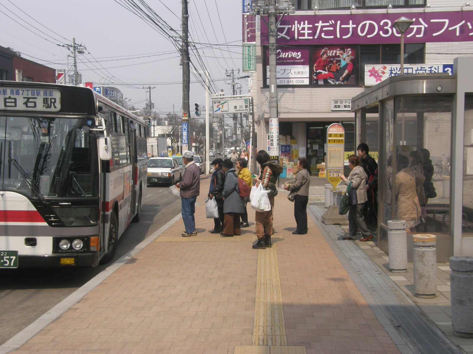
On the pavement, very close to the subway station is a sheltered bus stop. Here a bus has stopped to pick up and drop off. All very handy...

...and here's the train for you to try...

Showing posts with label Transit Oriented Design. Show all posts

Thursday, April 21, 2011

Narita Japan TOD and POD Study


This is a section of motorway in Japan on the way to Narita where I stayed a night on my way back to New Zealand. What strikes you is the similarity with NZ motorways. But there is where the similarity of transport design begins and ends...

This google map is a wide view of the section of Narita (a city within the Tokyo metropolitan area) where this little study is located...

...closer up you can see the finer grain of the urban landscape, including small detached cottage style housing, commercial buildings, roads and railway infrastructure...

This picture shows the study area. It shows the immediate catchment around a Narita commuter railway station. Each of the features in this labelled aerial picture are illustrated with video clips below...

This clip is recorded in the vicinity of the Bike Racks. It shows the traffic mix and density in the street as well as pedestrian and cycle traffic. You will see a man with an unusual job....

This clip recorded about 100 metres further along the street toward the station. Shows pedestrian and cycle traffic mix, shoppers coming and going, and camera pans past portraits of all the candidates standing locally (one size fits all), and shows commuters getting to the station access stairway...

You might have thought the bike parking by the shop was a little small, so check this system out.

Just in case you didn't believe me here's part of the under station scooter parking.

Here are the pedestrians, cyclists, scooter riders, and bus passengers walking the last hundred metres or so to the station - and encountering the usual political obstacles at election time!

And here's a classic clip of commuters waiting for a train which comes on the dot (as you might expect). It is impressive how little time it takes to unload, load, and go...

Wednesday, April 20, 2011

Sapporo Transport Oriented Design Study


This is a google image of the southern part of the city of Sapporo - the 5th biggest city in Japan - with a population of around 1.9 million people living at an average density of 1700 people/square kilometre. The map shows the main motorways and arterial roads in the city....

...this zoomed in area brings us closer to the case study ward of Sumikawa, where I stayed with my daughter for a few days last week. In this picture you see the layout of streets. A classic grid network. You can just make out the subway running vertically down the image. At this point it runs above ground.

... and here's a closeup of the study area. You can easily see the covered subway line, and in the centre of the picture is the station itself with translucent ceiling to let light in...

This picture shows the Subway infrastructure from street level. It's not the most attractive bit of urban infrastructure, but it's quiet (electric) and fume free. The street edges here are mostly activated with small cafes and shops. There is some car traffic but it's light. Most transport in the street network is by foot and bicycle...

...here is a small part of the cycle parking beneath the subway....

...and here's more cycle parking on the high street side of the Sumikawa subway station. This area of bike parking seems to be more utilised by those shopping in the area...

The broad pavements are busy with pedestrians - at this time of day mainly shopping - commuters have already gone to work... Note the marking and provision for the blind.

Here's that bike park by the shops again (back across the road), and you can see a cyclist approaching along the footpath. Many cyclists choose to bike on the footpath - it's wide enough - and bikes don't go more than around 15 kms per hour. Nobody wears a helmet...

On the pavement, very close to the subway station is a sheltered bus stop. Here a bus has stopped to pick up and drop off. All very handy...

...and here's the train for you to try...