Saturday, August 6, 2011

Auckland Waterfront Fantastic

I went down to the Waterfront this morning for an opening celebration. There was a Maori Pouwhiri at sunrise. Waka. Classic boats lined the wharves. And so did the people. The public spaces and places down here are a revelation. Auckland has done itself proud. Go there. Walk around. And enjoy....


AMETI Traffic Sewer Still On Track


I was asked to give a lecture on the AMETI project to Masters in Planning students at Auckland University, who are investigating urban design aspects of the Tamaki Transformation project. I wanted to give a bit of the planning history and put what's happening there in a political planning context....

As far back as 1946 the then Ministry of Works had designs on the corridor for a new highway. The goal was to connect the suburbs of Tamaki with Auckland CBD. There were also plans for suburban rail improvements at the time. This graphic I have borrowed from www.transportblog.co.nz.

And the De Leuw Cather work in the 1960's continued the idea of an Eastern Highway - which was clearly marked on their planning maps.

This image taken from Auckland Council's GIS system shows the lay of the land today - and highlights the fact that a transport designation has been in force along most of the proposed highway route for a long time. Much of it is green space. The Eastern Rail line occupies some of the corridor.

From 2002 to 2004 Mayor John Banks floated the idea again of the Eastern Motorway. He even had designs on Ngataringa Point (where I live) for a tunnel. But the main point of this slide is to show the alignment of the proposed Eastern Motorway - connecting Tamaki suburbs with Auckland CBD. Regardless of what happens along the way - how many houses might be removed and so on.

Various resident groups rose up in opposition. Particularly the residents around Hobson Bay who did not want to see that little bit of paradise damaged by such a huge corridor. They made up this computer image of how the whole thing might look running through Hobson Bay. This was the start of strong opposition to Mayor Bank's project. In fact it directly led to his downfall, and to the election of a number of new councillors to Auckland Council in 2004. They reversed the Eastern Motorway Project, and out of this emerged AMETI.

Considerable planning efforts were made to change the emphasis of the project, to promote public transport, cycling and pedestrian amenity. I sat on the South Western/Eastern Corridor Steering Group for 3 years (as ARC's representative) from 2004 to 2007, and advocated for the need to integrate land use planning with changes to transport. This approach was generally supported and appreciated at the time. However Auckland City Council did not handle related plan changes at all well, and the Panmure community in particular became angry, organised, public meetings occurred, and eventually Auckland City Council backed off significant aspects of a residential and commercial intensification project (Plan Change 59 and Plan Change 142).

The AMETI project went into recess for a time. It had become very expensive too. What was clear to me throughout, was that traffic engineers from Auckland City and Manukau City had long ago prepared engineering drawings for road widening projects through and around Panmure and Glen Innes. They were keen to get them built. It was always a case of "we need to widen the road to decongest the traffic - and then we'll fix public transport..."

Last year Auckland had local government amalgamation, and the whole AMETI project got tipped into the Auckland Transport CCO. Auckland Transport has been working hard on the project and in April had an open day down at Panmure where various transport designs were shown. I was amazed to see that we now have an "AMETI ROAD". A new road is proposed to decongest traffic. A number of huge "Manukau City" type interchanges are proposed. As shown here. Concern is being expressed about how the public transport dimension will work - for example there is an existing rail service: how will it be interconnected with a proposed busway? Or will it compete? Will a new bypass road draw custom away from public transport infrastructure...?

Around Panmure the design is interesting as shown in these images. A box section is proposed - local arterial road above local arterial bypass below. It is unclear how long this elevated corridor runs but it seems to be 500 metres or so. You can see the cross section proposed. It looks like a creative option, but it's hard to escape the conclusion that "AMETI ROAD" will act as an Eastern Highway. High traffic volumes, and massive severing effects on local communities of Panmure and Glen Innes. Politically what seems to have happened is this: The Eastern Highway idea has never gone away. It keeps getting reborn in different guises. Auckland City Council had a serious attempt at integrating land use planning with transport planning in the mid 2000's, but mis-managed it, not helped by leaky building crisis played out in the headlines. Reaction by community against crappy medium density housing. Then we had amalgamation, and the silo of Auckland Transport created. It has picked up AMETI - but along the way the need to integrate the project with land use changes risks being overlooked.

I understand there is a forum of some kind where Auckland Council officials sit down with Auckland Transport officials - but this has all the hallmarks of a project where the road builders have all the money and all the cards. It will be the residents of Panmure and Glen Innes who risk losing out in the long term. They are quiet now because no-one is trying to push medium/high density plan changes on them.

These projects do take time. It is essential to bring the community along - not for the ride - but to ensure the best overall outcomes are delivered. AMETI needs to be about integrated outcomes. Auckland does not need another traffic sewer.

And of course no presentation about transport planning at University is complete without a few words from Mumford.

Friday, August 5, 2011

Floods in USA vs Earthquakes in NZ

I'm doing some lecturing in the Planning School of Auckland University at the moment and get to attend some interesting talks from visiting experts. Like Wayne Feiden from Northampton in the US of A. He talked about natural hazard management in the US. It was extremely interesting to learn what happens there. Especially when we know waht has actually happened here in Christchurch. This slide shows the relative incidence of natural disasters across the USA. It appears these statistics are signed at the highest level. Presidential Disaster Declarations. We were advised that flooding is the biggest single cause of natural disasters. I remember all the news about the Mississippi and how those people all just walked away from their houses when they got flooded. You might remember. And none of them were insured....

Wayne showed us a few images from the damage done at New Orleans by Hurricane Katrina. He explained that before the suburbs got built out in New Orleans, there had been large tracts of wetlands which had absorbed the energy of hurricanes in the past. These were the houses that copped the most damage because they were built on low lying land.

He explained how many of these houses were built on low cost low lying concrete foundations - with no room for flood waters to flow beneath - and no height above flood waters either.

Apparently after the flood a high amount of planning and regulation got forced through. Rushed through. Someone had the bright idea of trailer park housing (remember that George Wood), and people and families have been living that way for years. Very poor, damp, humid style of housing. Especially bad in winter. And pretty awful in hot summers also.

But it was Wayne's information about state coverage of flood damage that made me sit up. You can see in this slide that 1% chance of flooding areas are Federally mapped - ie the US of A does that mapping. Not even state governments. These are signed off at the very highest level. And - he said - you cannot get private flood insurance. The US of A has a National Flood Insurance program (sounds a bit like the Earthquake Commission....)

Apparently it is - in theory - a self-supporting fund. But it was the next bit that was very interesting. He described that what comes with the fund is a VERY large carrot (they will cover all the costs of flood damage), and a VERY large stick (you can't qualify for this national flood damage insurance unless local land use regulations and building codes comply with Federal Rules.)

This detail strikes at the heart of what has gone wrong in Christchurch with insurance and EQC cover it seems to me. The EQC pays $100,000 on every house (more or less) doesn't matter if it was built badly, or if it was build on land the Council knew would liquify. There was no incentive in Chch for council's to act appropriately, nor builders, nor developers. Sure some people had a private top up insurance - but they've run a mile now.

I like this slide. He explained that in a very short time, the earthquakes in Chricthcurch will be forgotten. So it is essential to make institutional changes now, while there is an appreciation of what is necessary, and what went wrong. But - as I've indicated before - I wonder whether the Canterbury Inquiry is ready to grasp that nettle.

Council's Relentless Waterfront Sale

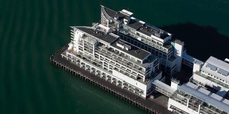
"Where is Auckland Council's Waterfront Masterplan?" is the question I asked nobody in particular as I read NZ Herald's apparently innocuous news item about the sale of the Hilton Hotel on Princes Wharf.


The article ran in Granny Herald within the August 3rd Business section.
".....The five-star boutique Hilton Auckland has been put up for sale in an international campaign but its American operator will continue to run it and the property will stay a Hilton.

Dean Humphries, Jones Lang LaSalle Hotels' executive vice-president, who was appointed to sell the property exclusively said Hilton Hotels would manage it for the new owner as part of its operations here, which also include Hiltons at Taupo and Queenstown.

Brian Fitzgerald, an investor, said the property belonged to a number of parties including Willeston Capital.

"It's a great time to sell, never better. You won't sell just because of Rugby World Cup but it's performing well," Fitzgerald said.

Auckland Council records shows the Hilton, at 141 Quay St, was valued at $44.6 million in July 2008.

Its top floor is the quarter-acre apartment of bankrupt property developer David Henderson, whose Kitchener Group developed all six buildings on the wharf, creating bars, restaurants, covered carparking, apartments, offices and the hotel. Henderson still lives in the apartment, despite attempts to sell it for about $10 million.

All the wharf properties are on terminating leases, set to run for another 84 years, so that after then the buildings have no legal right to occupy the wharf space.

Hilton's restaurant White has been shut for some time as it undergoes a refurbishment and is expected to have a new name when it reopens.

Humphries said the ground-floor Overseas Passenger Terminal in the building was part of the sale deal.
That made me sit up. The Overseas Passenger Terminal on Princes Wharf is apparently up for sale along with the Hilton Hotel. Makes sense I suppose. One careful owner since 2001. Lock and stock and barrel up for sale.

The history of how this all got built, and shifted from public ownership and into private control is not a happy history - especially if you believe there needs to be much more in the way of a destination focus for Auckland's 1.4 million people down there. How many councillors understand that even council's own plans for Princes Wharf redevelopment included art galleries, museums, and a cinema.

Have a look at this if you need reminding: How Sad is Princes Wharf?, and How Sad is Princes Wharf - Part II

But I digress. Back to Granny Herald's story:
Humphries said the ground-floor Overseas Passenger Terminal in the building was part of the sale deal.

"This also acts as a conference and exhibition centre for the hotel.
So. Here we have the agent acting on behalf of the owners, talking up the alternative uses of what we know as Auckland's Overseas Passenger Terminal. So. Auckland didn't get a cinema, or a museum, or much else in the way of public waterfront amenity on Princes Wharf. The cruise ship industry has turned its nose up at the facilities it has had access to and use of for close to a decade. And now it's apparently for sale. So where are they going to go? Read further on in the story...

"Auckland Council has indicated that the passenger terminal will move to Queens Wharf in the 2012-13 cruise ship season, which will therefore allow the hotel to utilise this space more efficiently during future cruise ship seasons."

Man oh man. So that's the deal. Without even a whiff of a Waterfront Masterplan, Auckland Council has indicated that the passenger terminal will move to Queens Wharf.

So. Auckland's relentless and destructive policy of privatising waterfront amenity is still alive and well under King Len and his happy Councillors. And I thought the whole reason for having a Waterfront Development Agency was to take an integrated look at Auckland's whole waterfront.

This piecemeal sale of Princes Wharf is an injury by itself, but if that sale also inevitably leads to the sale of much of Queens Wharf's amenity to the cruise ship industry, then it will be an insult to Auckland.

Fonterra's Unsustainable Thirst

The caption that ran with this Fonterra story: The dairy industry has a lot to smile about given New Zealand's advantages....


On Saturday June 18th, NZ Herald's Business pages carried a useful article with a set of indicators which explain why Fonterra's current activities in New Zealand are fundamentally unsustainable...

At our annual investor conference last week, one of the presentations was from Fonterra. Feedback from the 600 private client attendees was that this was one of the most interesting talks of the day....

The first point made by Jonathan Mason, Fonterra's chief financial officer, was that New Zealand is a great place for dairy farming, if not the best in the world. The key reason is simple. We have an abundance of water, which makes us great at growing grass and gives us a distinct cost advantage over many countries.

According to Water NZ, New Zealand receives the same amount of rainfall that lands on the entire Australian continent each year, despite Australia being 28 times our size. This ample rainfall underpins New Zealand's position as a low-cost producer of protein.

Our rainfall averages 2m a year, more than double the 0.8m world average.....

Now, while this might be true, the reality is that New Zealand ranges from being water rich to water poor. In fact using international metrics, the rainfall in Canterbury and Otago is low. Yet this is where Fonterra and its legions of farmers are attempting to establish these water hungry enterprises. Eere is what Environment Canterbury says on its website:
The Canterbury Plains themselves have relatively low rainfall and the normally fast-draining characteristics of the soils and rock mean large seasonal fluctuations in the soil moisture content.

Rainfall recharge is therefore critical to maintain groundwater levels and thus the supply of water in these drier areas during spring and summer.

Christchurch has an average annual rainfall of 648 millimetres (roughly half that of Auckland and Wellington). So. To talk of average rainfall in the vicinity of 2 metres a year is plain misleading.

And Otago is no better.

Met Service data says this about rainfall in New Zealand:
The mean annual rainfall ranges from as little as 300mm in a small area of Central Otago to over 8000mm in the Southern Alps. The average for the whole country is high, but for the greater part lies between 600 and 1500mm. The only areas with average rainfalls under 600mm are found in the South Island to the east of the main ranges, and include most of Central and North Otago, and South Canterbury.

These are the very driest parts of New Zealand. Otago and South Canterbury - but these are just the areas that are being targetted for conversion to dairy in what amounts to one of the most damaging tragedies of the commons that New Zealand has ever faced. And it is supported by Central Government.

The Herald article continues:
This level of rainfall has a huge bearing on our ability to provide pasture for grazing dairy cows and gives us a strong competitive advantage over other parts of the world that have to supplement their stock with various types of feed, which are usually grain-based. While few local dairy farmers use grain-based supplements, as much as 90 per cent of the rest of the world's dairy cows rely on this, and face its consequently higher cost structure....

Australia and some parts of South America and South Africa operate in a similar way to us, and certain areas in the United States have begun to adopt our model. However, New Zealand still offers a superior environment. We have a stable political landscape and a reputation for safe, high-quality food products in our favour, too....

You see what I mean about "Government support". 50 years ago New Zealand was wealthy because we had 70,000,000 sheep that stripped vegetation to bedrock in the high country (no more soil left, it all washed away), and Great Britain bought most of the meat while NZ benefitted from Fergusons and Vanguards and washing machines. Now it's milk fat and China buys a lot of it and we get all those plasma screens and cheap stuff to buy in the Warehouse. But does that make it alright?

A co-operative owned by 10,500 farmer shareholders, Fonterra is the world's largest exporter of milk powder, has revenue of $17 billion and operating earnings of $1 billion. It has 432 tankers across 17 depots, operates 86 plants in New Zealand and has the largest milk dryers in the world. It uses 11 New Zealand ports to send 140,000 containers each year to its millions of customers in 140 different countries.

While New Zealand only accounts for about 2 per cent of world dairy production, we export 95 per cent of this. This is in contrast with most other dairy producing nations around the world, where the vast majority is consumed domestically.

Unsurprisingly, China is a key export market, taking nearly a third of Fonterra's milk products last year.... China's growing demand for high-value agricultural products bodes well for New Zealand. The local agricultural sector, blessed as it is with high rainfall, is well placed to benefit from a China that is expected to become a major importer of food....

And so it goes, and it gets better....

In addition to the growing demand, water shortages could see China become a major food importer in future. China has only one-third of the freshwater per capita of the global average and, unfortunately, the worst water shortages often coincide with the populous northern region.... As urbanisation continues, a higher proportion of fresh water will be required for residential consumption, further limiting what is available for use in agriculture.

This good news story makes no mention of the enormous long term damage that is being done to New Zealand's waterways, rivers, and lakes. I don't know how this environmental damage stacks up alongside what happened to NZ's high country, but it is not good, and it fundamentally affects our own enjoyment of our country - let alone what's happening to fresh water ecosystems. And it is dishonest to suggest that the very areas where dairy farming is expanding have "ample water". They do not. They fall into the category of "water impoverished". And the more water that is sucked out of the ground in these parts of New Zealand to force-irrigate grass, the quicker we will kill the country's rivers.

It can't last, and it needs to change.

But in the meantime, Fonterra's bosses will make hay...
Any land-based venture is not without risk and cyclical ups and downs are to be expected. It should also be noted it does not provide specific exposure to dairy farms or the commodity milk price - rather, it is a manufacturer and marketing company of dairy products. However, the long-term growth potential for Fonterra is enormous.


Saturday, August 6, 2011

Auckland Waterfront Fantastic

I went down to the Waterfront this morning for an opening celebration. There was a Maori Pouwhiri at sunrise. Waka. Classic boats lined the wharves. And so did the people. The public spaces and places down here are a revelation. Auckland has done itself proud. Go there. Walk around. And enjoy....


AMETI Traffic Sewer Still On Track


I was asked to give a lecture on the AMETI project to Masters in Planning students at Auckland University, who are investigating urban design aspects of the Tamaki Transformation project. I wanted to give a bit of the planning history and put what's happening there in a political planning context....

As far back as 1946 the then Ministry of Works had designs on the corridor for a new highway. The goal was to connect the suburbs of Tamaki with Auckland CBD. There were also plans for suburban rail improvements at the time. This graphic I have borrowed from www.transportblog.co.nz.

And the De Leuw Cather work in the 1960's continued the idea of an Eastern Highway - which was clearly marked on their planning maps.

This image taken from Auckland Council's GIS system shows the lay of the land today - and highlights the fact that a transport designation has been in force along most of the proposed highway route for a long time. Much of it is green space. The Eastern Rail line occupies some of the corridor.

From 2002 to 2004 Mayor John Banks floated the idea again of the Eastern Motorway. He even had designs on Ngataringa Point (where I live) for a tunnel. But the main point of this slide is to show the alignment of the proposed Eastern Motorway - connecting Tamaki suburbs with Auckland CBD. Regardless of what happens along the way - how many houses might be removed and so on.

Various resident groups rose up in opposition. Particularly the residents around Hobson Bay who did not want to see that little bit of paradise damaged by such a huge corridor. They made up this computer image of how the whole thing might look running through Hobson Bay. This was the start of strong opposition to Mayor Bank's project. In fact it directly led to his downfall, and to the election of a number of new councillors to Auckland Council in 2004. They reversed the Eastern Motorway Project, and out of this emerged AMETI.

Considerable planning efforts were made to change the emphasis of the project, to promote public transport, cycling and pedestrian amenity. I sat on the South Western/Eastern Corridor Steering Group for 3 years (as ARC's representative) from 2004 to 2007, and advocated for the need to integrate land use planning with changes to transport. This approach was generally supported and appreciated at the time. However Auckland City Council did not handle related plan changes at all well, and the Panmure community in particular became angry, organised, public meetings occurred, and eventually Auckland City Council backed off significant aspects of a residential and commercial intensification project (Plan Change 59 and Plan Change 142).

The AMETI project went into recess for a time. It had become very expensive too. What was clear to me throughout, was that traffic engineers from Auckland City and Manukau City had long ago prepared engineering drawings for road widening projects through and around Panmure and Glen Innes. They were keen to get them built. It was always a case of "we need to widen the road to decongest the traffic - and then we'll fix public transport..."

Last year Auckland had local government amalgamation, and the whole AMETI project got tipped into the Auckland Transport CCO. Auckland Transport has been working hard on the project and in April had an open day down at Panmure where various transport designs were shown. I was amazed to see that we now have an "AMETI ROAD". A new road is proposed to decongest traffic. A number of huge "Manukau City" type interchanges are proposed. As shown here. Concern is being expressed about how the public transport dimension will work - for example there is an existing rail service: how will it be interconnected with a proposed busway? Or will it compete? Will a new bypass road draw custom away from public transport infrastructure...?

Around Panmure the design is interesting as shown in these images. A box section is proposed - local arterial road above local arterial bypass below. It is unclear how long this elevated corridor runs but it seems to be 500 metres or so. You can see the cross section proposed. It looks like a creative option, but it's hard to escape the conclusion that "AMETI ROAD" will act as an Eastern Highway. High traffic volumes, and massive severing effects on local communities of Panmure and Glen Innes. Politically what seems to have happened is this: The Eastern Highway idea has never gone away. It keeps getting reborn in different guises. Auckland City Council had a serious attempt at integrating land use planning with transport planning in the mid 2000's, but mis-managed it, not helped by leaky building crisis played out in the headlines. Reaction by community against crappy medium density housing. Then we had amalgamation, and the silo of Auckland Transport created. It has picked up AMETI - but along the way the need to integrate the project with land use changes risks being overlooked.

I understand there is a forum of some kind where Auckland Council officials sit down with Auckland Transport officials - but this has all the hallmarks of a project where the road builders have all the money and all the cards. It will be the residents of Panmure and Glen Innes who risk losing out in the long term. They are quiet now because no-one is trying to push medium/high density plan changes on them.

These projects do take time. It is essential to bring the community along - not for the ride - but to ensure the best overall outcomes are delivered. AMETI needs to be about integrated outcomes. Auckland does not need another traffic sewer.

And of course no presentation about transport planning at University is complete without a few words from Mumford.

Friday, August 5, 2011

Floods in USA vs Earthquakes in NZ

I'm doing some lecturing in the Planning School of Auckland University at the moment and get to attend some interesting talks from visiting experts. Like Wayne Feiden from Northampton in the US of A. He talked about natural hazard management in the US. It was extremely interesting to learn what happens there. Especially when we know waht has actually happened here in Christchurch. This slide shows the relative incidence of natural disasters across the USA. It appears these statistics are signed at the highest level. Presidential Disaster Declarations. We were advised that flooding is the biggest single cause of natural disasters. I remember all the news about the Mississippi and how those people all just walked away from their houses when they got flooded. You might remember. And none of them were insured....

Wayne showed us a few images from the damage done at New Orleans by Hurricane Katrina. He explained that before the suburbs got built out in New Orleans, there had been large tracts of wetlands which had absorbed the energy of hurricanes in the past. These were the houses that copped the most damage because they were built on low lying land.

He explained how many of these houses were built on low cost low lying concrete foundations - with no room for flood waters to flow beneath - and no height above flood waters either.

Apparently after the flood a high amount of planning and regulation got forced through. Rushed through. Someone had the bright idea of trailer park housing (remember that George Wood), and people and families have been living that way for years. Very poor, damp, humid style of housing. Especially bad in winter. And pretty awful in hot summers also.

But it was Wayne's information about state coverage of flood damage that made me sit up. You can see in this slide that 1% chance of flooding areas are Federally mapped - ie the US of A does that mapping. Not even state governments. These are signed off at the very highest level. And - he said - you cannot get private flood insurance. The US of A has a National Flood Insurance program (sounds a bit like the Earthquake Commission....)

Apparently it is - in theory - a self-supporting fund. But it was the next bit that was very interesting. He described that what comes with the fund is a VERY large carrot (they will cover all the costs of flood damage), and a VERY large stick (you can't qualify for this national flood damage insurance unless local land use regulations and building codes comply with Federal Rules.)

This detail strikes at the heart of what has gone wrong in Christchurch with insurance and EQC cover it seems to me. The EQC pays $100,000 on every house (more or less) doesn't matter if it was built badly, or if it was build on land the Council knew would liquify. There was no incentive in Chch for council's to act appropriately, nor builders, nor developers. Sure some people had a private top up insurance - but they've run a mile now.

I like this slide. He explained that in a very short time, the earthquakes in Chricthcurch will be forgotten. So it is essential to make institutional changes now, while there is an appreciation of what is necessary, and what went wrong. But - as I've indicated before - I wonder whether the Canterbury Inquiry is ready to grasp that nettle.

Council's Relentless Waterfront Sale

"Where is Auckland Council's Waterfront Masterplan?" is the question I asked nobody in particular as I read NZ Herald's apparently innocuous news item about the sale of the Hilton Hotel on Princes Wharf.


The article ran in Granny Herald within the August 3rd Business section.
".....The five-star boutique Hilton Auckland has been put up for sale in an international campaign but its American operator will continue to run it and the property will stay a Hilton.

Dean Humphries, Jones Lang LaSalle Hotels' executive vice-president, who was appointed to sell the property exclusively said Hilton Hotels would manage it for the new owner as part of its operations here, which also include Hiltons at Taupo and Queenstown.

Brian Fitzgerald, an investor, said the property belonged to a number of parties including Willeston Capital.

"It's a great time to sell, never better. You won't sell just because of Rugby World Cup but it's performing well," Fitzgerald said.

Auckland Council records shows the Hilton, at 141 Quay St, was valued at $44.6 million in July 2008.

Its top floor is the quarter-acre apartment of bankrupt property developer David Henderson, whose Kitchener Group developed all six buildings on the wharf, creating bars, restaurants, covered carparking, apartments, offices and the hotel. Henderson still lives in the apartment, despite attempts to sell it for about $10 million.

All the wharf properties are on terminating leases, set to run for another 84 years, so that after then the buildings have no legal right to occupy the wharf space.

Hilton's restaurant White has been shut for some time as it undergoes a refurbishment and is expected to have a new name when it reopens.

Humphries said the ground-floor Overseas Passenger Terminal in the building was part of the sale deal.
That made me sit up. The Overseas Passenger Terminal on Princes Wharf is apparently up for sale along with the Hilton Hotel. Makes sense I suppose. One careful owner since 2001. Lock and stock and barrel up for sale.

The history of how this all got built, and shifted from public ownership and into private control is not a happy history - especially if you believe there needs to be much more in the way of a destination focus for Auckland's 1.4 million people down there. How many councillors understand that even council's own plans for Princes Wharf redevelopment included art galleries, museums, and a cinema.

Have a look at this if you need reminding: How Sad is Princes Wharf?, and How Sad is Princes Wharf - Part II

But I digress. Back to Granny Herald's story:
Humphries said the ground-floor Overseas Passenger Terminal in the building was part of the sale deal.

"This also acts as a conference and exhibition centre for the hotel.
So. Here we have the agent acting on behalf of the owners, talking up the alternative uses of what we know as Auckland's Overseas Passenger Terminal. So. Auckland didn't get a cinema, or a museum, or much else in the way of public waterfront amenity on Princes Wharf. The cruise ship industry has turned its nose up at the facilities it has had access to and use of for close to a decade. And now it's apparently for sale. So where are they going to go? Read further on in the story...

"Auckland Council has indicated that the passenger terminal will move to Queens Wharf in the 2012-13 cruise ship season, which will therefore allow the hotel to utilise this space more efficiently during future cruise ship seasons."

Man oh man. So that's the deal. Without even a whiff of a Waterfront Masterplan, Auckland Council has indicated that the passenger terminal will move to Queens Wharf.

So. Auckland's relentless and destructive policy of privatising waterfront amenity is still alive and well under King Len and his happy Councillors. And I thought the whole reason for having a Waterfront Development Agency was to take an integrated look at Auckland's whole waterfront.

This piecemeal sale of Princes Wharf is an injury by itself, but if that sale also inevitably leads to the sale of much of Queens Wharf's amenity to the cruise ship industry, then it will be an insult to Auckland.

Fonterra's Unsustainable Thirst

The caption that ran with this Fonterra story: The dairy industry has a lot to smile about given New Zealand's advantages....


On Saturday June 18th, NZ Herald's Business pages carried a useful article with a set of indicators which explain why Fonterra's current activities in New Zealand are fundamentally unsustainable...

At our annual investor conference last week, one of the presentations was from Fonterra. Feedback from the 600 private client attendees was that this was one of the most interesting talks of the day....

The first point made by Jonathan Mason, Fonterra's chief financial officer, was that New Zealand is a great place for dairy farming, if not the best in the world. The key reason is simple. We have an abundance of water, which makes us great at growing grass and gives us a distinct cost advantage over many countries.

According to Water NZ, New Zealand receives the same amount of rainfall that lands on the entire Australian continent each year, despite Australia being 28 times our size. This ample rainfall underpins New Zealand's position as a low-cost producer of protein.

Our rainfall averages 2m a year, more than double the 0.8m world average.....

Now, while this might be true, the reality is that New Zealand ranges from being water rich to water poor. In fact using international metrics, the rainfall in Canterbury and Otago is low. Yet this is where Fonterra and its legions of farmers are attempting to establish these water hungry enterprises. Eere is what Environment Canterbury says on its website:
The Canterbury Plains themselves have relatively low rainfall and the normally fast-draining characteristics of the soils and rock mean large seasonal fluctuations in the soil moisture content.

Rainfall recharge is therefore critical to maintain groundwater levels and thus the supply of water in these drier areas during spring and summer.

Christchurch has an average annual rainfall of 648 millimetres (roughly half that of Auckland and Wellington). So. To talk of average rainfall in the vicinity of 2 metres a year is plain misleading.

And Otago is no better.

Met Service data says this about rainfall in New Zealand:
The mean annual rainfall ranges from as little as 300mm in a small area of Central Otago to over 8000mm in the Southern Alps. The average for the whole country is high, but for the greater part lies between 600 and 1500mm. The only areas with average rainfalls under 600mm are found in the South Island to the east of the main ranges, and include most of Central and North Otago, and South Canterbury.

These are the very driest parts of New Zealand. Otago and South Canterbury - but these are just the areas that are being targetted for conversion to dairy in what amounts to one of the most damaging tragedies of the commons that New Zealand has ever faced. And it is supported by Central Government.

The Herald article continues:
This level of rainfall has a huge bearing on our ability to provide pasture for grazing dairy cows and gives us a strong competitive advantage over other parts of the world that have to supplement their stock with various types of feed, which are usually grain-based. While few local dairy farmers use grain-based supplements, as much as 90 per cent of the rest of the world's dairy cows rely on this, and face its consequently higher cost structure....

Australia and some parts of South America and South Africa operate in a similar way to us, and certain areas in the United States have begun to adopt our model. However, New Zealand still offers a superior environment. We have a stable political landscape and a reputation for safe, high-quality food products in our favour, too....

You see what I mean about "Government support". 50 years ago New Zealand was wealthy because we had 70,000,000 sheep that stripped vegetation to bedrock in the high country (no more soil left, it all washed away), and Great Britain bought most of the meat while NZ benefitted from Fergusons and Vanguards and washing machines. Now it's milk fat and China buys a lot of it and we get all those plasma screens and cheap stuff to buy in the Warehouse. But does that make it alright?

A co-operative owned by 10,500 farmer shareholders, Fonterra is the world's largest exporter of milk powder, has revenue of $17 billion and operating earnings of $1 billion. It has 432 tankers across 17 depots, operates 86 plants in New Zealand and has the largest milk dryers in the world. It uses 11 New Zealand ports to send 140,000 containers each year to its millions of customers in 140 different countries.

While New Zealand only accounts for about 2 per cent of world dairy production, we export 95 per cent of this. This is in contrast with most other dairy producing nations around the world, where the vast majority is consumed domestically.

Unsurprisingly, China is a key export market, taking nearly a third of Fonterra's milk products last year.... China's growing demand for high-value agricultural products bodes well for New Zealand. The local agricultural sector, blessed as it is with high rainfall, is well placed to benefit from a China that is expected to become a major importer of food....

And so it goes, and it gets better....

In addition to the growing demand, water shortages could see China become a major food importer in future. China has only one-third of the freshwater per capita of the global average and, unfortunately, the worst water shortages often coincide with the populous northern region.... As urbanisation continues, a higher proportion of fresh water will be required for residential consumption, further limiting what is available for use in agriculture.

This good news story makes no mention of the enormous long term damage that is being done to New Zealand's waterways, rivers, and lakes. I don't know how this environmental damage stacks up alongside what happened to NZ's high country, but it is not good, and it fundamentally affects our own enjoyment of our country - let alone what's happening to fresh water ecosystems. And it is dishonest to suggest that the very areas where dairy farming is expanding have "ample water". They do not. They fall into the category of "water impoverished". And the more water that is sucked out of the ground in these parts of New Zealand to force-irrigate grass, the quicker we will kill the country's rivers.

It can't last, and it needs to change.

But in the meantime, Fonterra's bosses will make hay...
Any land-based venture is not without risk and cyclical ups and downs are to be expected. It should also be noted it does not provide specific exposure to dairy farms or the commodity milk price - rather, it is a manufacturer and marketing company of dairy products. However, the long-term growth potential for Fonterra is enormous.