|
|
|
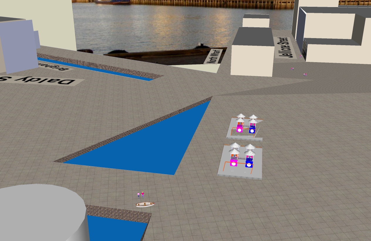
By the way, in the bottom left of the image you can see the top of a cement silo. Which is around about where the Waterfront Development Plan photo was taken from... |
|
The other new building is the "cheese wedge" to the left, along Wynyard Wharf. This is planned to be 5 stories high and is intended to be a residential development block. |
This image gives an idea of the urban canyon design that is planned for Jellicoe Street. (Love the open space feel it now has - while you can.) |
|
The purpose of my computer generated impression is to convey a sense of the urban design that is actually planned for Jellicoe when all of the anticipated building development is complete. It is not a park at all. A far cry from what you see now, and from the misleading impression in the photographs used in the Waterfront Development Plan. Why? You might think. Well. The Waterfront Development Plan as it stands is like a coffee table prospectus for future investors in Wynyard Quarter. They will love the pictures of smiling people. Future customers for their future developments. It's a brochure for investors rather than genuine consultation. I think the kind of public confusion that these images cause, can lead to a false sense of comfort, a false feeling that - at last - Council is taking seriously public calls for quality waterfront public space. It is also why I am concerned that the same sort of private development overcrowding will occur elsewhere on Auckland's waterfront (as it did on Princes Wharf). I had hoped for a more honest communication from Waterfront Development Agency. It does not augur well for what is planned behind closed doors for Queens Wharf. |


Sunday, October 16, 2011
Wynyard Quarter Playground Con Job
|
|
|
By the way, in the bottom left of the image you can see the top of a cement silo. Which is around about where the Waterfront Development Plan photo was taken from... |
|
The other new building is the "cheese wedge" to the left, along Wynyard Wharf. This is planned to be 5 stories high and is intended to be a residential development block. |
This image gives an idea of the urban canyon design that is planned for Jellicoe Street. (Love the open space feel it now has - while you can.) |
|
The purpose of my computer generated impression is to convey a sense of the urban design that is actually planned for Jellicoe when all of the anticipated building development is complete. It is not a park at all. A far cry from what you see now, and from the misleading impression in the photographs used in the Waterfront Development Plan. Why? You might think. Well. The Waterfront Development Plan as it stands is like a coffee table prospectus for future investors in Wynyard Quarter. They will love the pictures of smiling people. Future customers for their future developments. It's a brochure for investors rather than genuine consultation. I think the kind of public confusion that these images cause, can lead to a false sense of comfort, a false feeling that - at last - Council is taking seriously public calls for quality waterfront public space. It is also why I am concerned that the same sort of private development overcrowding will occur elsewhere on Auckland's waterfront (as it did on Princes Wharf). I had hoped for a more honest communication from Waterfront Development Agency. It does not augur well for what is planned behind closed doors for Queens Wharf. |
1 comment:
-
Could you please highlight the fact that Aucklanders can have their say on this and four other key issues at the Heart of the City campaign site WWW.WEONLYGETONECHANCE.CO.NZ
Data collected here will be used in HOTC submission for the Draft Auckland Plan. -
October 20, 2011 at 3:08 PM


1 comment:
Could you please highlight the fact that Aucklanders can have their say on this and four other key issues at the Heart of the City campaign site WWW.WEONLYGETONECHANCE.CO.NZ
Data collected here will be used in HOTC submission for the Draft Auckland Plan.
Post a Comment