Monday, November 16, 2015

Public Open Spaces: NY3

This is a schematic map of Times Square public space in Manhattan, New York. The area bounded by the orange triangle is mostly open public space. Streets cross it, but the public space spans east to west from activated edge to activated edge. My pictures start from the star, as I walk through the space, on an autumn Saturday around mid-day. And it was cold, and blowing....

You might recall those images when - as an experiment - NY put deck chairs through Times Square. Well, now it's red tables and chairs. People put them where they want them.

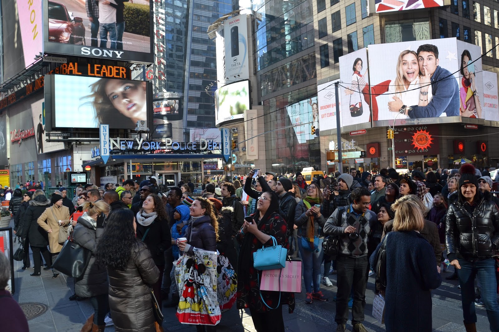
tTimes Square is really a pedestrian mall - but people hang about. Snack. People watch. Pause. But a lot of coming and going happens here...

So tables are often empty, but inviting....

There are whole families here. Safe. Fun. Took me a while to work out what was happening with the Revlon billboard...
You can see how rugged up these guys are. It was cold. Really cold wind...
Slight photographic digression here... this pic and the next with the polaroid filter....
And this one....
Back to Revlon. The billboard included a video camera. Every now and then it would show the crowd - this crowd... they'd all cheer... and then it would freeze the image.....
 
....and display it...if you look back you will see some of these characters, like the black man with shades...the crowd becomes the show....

And that's really what Times Square is all about. People watching...places for encounters...a challenging place to manage and keep happy... but boy, it works....

A lot of fun. Very public. Lots of individuals performing. Magnetic.
And again - after the sun moves in shade, they're still there, and the tables and places to sit fill and empty, fill and empty - simple food, simple human things to do....

NY Urban Plazas on video Flatiron and Madison

  To give a feel for how these public spaces work, video helps. Shades of William H Whyte's work decades ago.... Each of these 5 videos gives a different impression. First, a reminder - the time of year is fall - autumn. It's cold. The wind is cold. If you can find shelter from wind or find a patch of sun - that seems to be the goal. Useful to remember what Whyte found were the basics of successful urban space: seats, toilets, simple food, activity (shops etc) and - most important - other people.

This video gives a flavour of the simple public seating (btw - free wifi), simple food, and the demographic....
This video shows the surrounding buildings and the locality.  This public space is subject to shading and wind. People move the chairs and tables to suit themselves....
I moved for this video. To stay in the sun. Shows more what people are doing at their tables. People come and go. Not really a destination - just a place to chill for a bit. I finished my book sitting here. In fact (I kid you not) a woman approached me and asked whether I'd been an actor in a film... thinks, "is this the standard line in NY?" I asked her whether it was a baddie or a goodie. She wasn't sure. Then she suggested I go and sing some church songs... interesting... places for encounters...
The above video pans across the road from FlatIron to Madison Square. Much more formal and old. This video is inside the square. Hundreds of people sitting at tables in the shade - not of trees (all the leaves are gone) - but of surrounding buildings. People attract people. Simple food. Safe.
The FlatIron open space occupies a couple of paved areas. This is the second. Shows a sculpture being built. These places are dynamic. Curated. There's a feeling of freedom and public space about it all.

QE Square in Auckland could function like these urban spaces. We won't get it right first up, but neither did New York. These spaces and places can change because - apart from trees maybe - the infrastructure can be moved about. By public. By parks people. Food barrows and trailers are moveable. Experiment.

In this sort of PPP, we need Precinct and Auckland Transport and Auckland Council to play their parts, maximise their creative and constructive contributions to make this public space a success.

Thursday, November 12, 2015

Precinct's Downtown Laneway: How Wide?

This posting is about the laneway proposed in Precinct's plans for redevelopment of the Auckland Downtown block bounded by Lower Queen Street, Quay Street, Lower Albert Street and Custom Street West. The picture below shows a rough plan of this laneway.....


The laneway I want to discuss here, is the one connecting Lower Albert Street through the development to Lower Queen Street. The laneway will be about 100 metres long if the whole of Queen Square (shaded in green) is sold for development, and about 60 metres long if Queen Square stays in public ownership as public space. (The other proposed laneway, running north-south, is more of a dog leg than shown here, as it has to side-step the HSBC building to get to Quay Street.)

In June this year, Precinct obtained resource consent for a development on the site that does not use Queen Square. This consent was non-notified. It includes consent for the 60 metre section of laneway. The question I want to address in this posting is how wide should this laneway be?

At the hearings that have occurred in the past couple of weeks, there have been varying widths discussed by the applicant's experts and by Auckland Council. The Road Stop notice stipulates a 5 metre width east-west laneway. Other witnesses have said 6.5 metres, and that this provides a 5 metre wide central section, allowing shoppers to look at the shops using the other 1.5 metres of width. Various submitters have raised questions about the safety of this - because the laneway will be used by passengers to walk between the bus terminal in Albert Street and the Britomart rail terminal or other buses that terminate there.

At the Plan Change 79 hearing, Blair Johnston of Warren and Mahoney Architects, (who are doing master plan and architecture work for Precinct) stated that he had worked with Auckland Transport, and that modelling showed that a 5 metre wide corridor was safe and appropriate, even up to conservative estimates of 16,000 people going through per hour.

The world authority on these matters is John J Fruin. You can see a summary of his work for New York Transit here. This is a bit dense, so I've unpacked relevant sections....
PEDESTRIAN CHARACTERISTICS
The primary characteristics needed to evaluate pedestrian facilities are walking speeds, walking distances, demand patterns, and traffic-flow relationships. The ability of pedestrians to select their own individual walking pace and speed is a qualitative measure of convenience. Walking distances define the effective service area of transit stations, with shorter distances improving passenger perceptions of service and convenience. The patterns of passenger demand affect the methods used to analyze pedestrian facilities and the applications of service standards.
WALKING SPEEDS
Pedestrian speeds, in addition to being directly related to traffic density, have been found to vary for a wide range of conditions, including individual age, sex, personal disabilities, environmental factors, and trip purpose. Normal walking speeds unimpeded by pedestrian crowding have been found to vary between 150 and 350 ft/min (0.76 and 1.76 m/s), with the average at about 270 ft/min. As a point of comparison, running the 4-min mile is equivalent to a speed of 1320 ft/min or almost 5 times normal walking speed. Walking speeds decline with age, particularly after age 65, but healthy older adults are capable of increasing their walking speed by 40% for short distances. Dense pedestrian traffic has the effect of reducing walking speed for all persons. The smaller personal space limits pacing distances and the ability to pass slower moving pedestrians or to cross the traffic stream.
Photographic studies of pedestrian traffic flow on walkways have shown that individual area occupancies of at least 35 ft2/pr (3 m2/pr) are required for pedestrians to attain normal walking speeds and to avoid conflicts with others. Interestingly, the maximum pedestrian traffic-flow volume is not obtained when people can walk the fastest, but when average area occupancies are at about 5 ft2/pr, and pedestrians are limited to an uncomfortable shuffling gait less than half normal walking speed. At individual space occupancies below 2 ft2/pr, approaching the plan area of the human body, virtually all movement is stopped. When there is a large crowd in a confined space, this density can result in shock waves and potentially fatal crowd pressures.
Fruin has developed a set of useful metrics and measures that allow walking speeds and infrastructure capacity to be calculated. These are depicted in the following two diagrams and tables:


What this tabulates is the different levels of service (LOS) experienced by pedestrians, as the space between pedestrians gets more cramped, in order to get more people through the same corridor, per hour. LOS A is the most comfortable, and LOS E and LOS F are where things get tricky. In between is a LOS that gets the most people through, and retains an optimal level of comfort - but you can see that cross flows become difficult (eg people using the north-south laneway) etc.
This graph shows this relationship quantitatively. At the top are the different LOS, with "A" to the right. Which is described on the graph as "commuter bi-directional" - people easily going in both directions. Then you have LOS "B" described as "shoppers multi-directional", and then LOS "C" described as "commuter uni-directional" - people going in similar directions, and taking up between 15 and 25 square feet/person. And so on.

Crucially, Fruin, in his piece poses this question:
Determine the recommended width of a 200-ft (61-m)-long corridor connection to a transit station with a forecasted two-way, peak-hour pedestrian traffic of 10,000 pr/h under the following conditions:
Alternative 1: commuters only, no doors entering the corridor, no columns, no other services.
Alternative 2: same volume, but with retail development along the corridor edges in a shopping mall configuration.
And provides the answers (which you can look at in the link) as follows:

Solution for Alternative 1: This requires the selection of a design LOS and appropriate design peak. Unless there are significant restraints, the approximate mid-range of LOS C, or 12.5 pr/ft min, is an appropriate standard. The 15-min peak, typically about 40% of peak-hour volume, is an appropriate design period. (Ans=6.8 metres) 
Solution for Alternative 2: The shopping mall alternative can be analyzed as (a) a corridor with additions at the edges to allow window-shopping and door-opening "lanes" or (b) on a time-space basis, assuming some percentage of the commuters will spend additional time in the corridor. For illustrative purposes, it will be assumed that 100% of the commuters walk through the corridor, but that 30% of this total stop to window-shop for an additional 1 min each. It is desired to provide a density of 20 ft2/p average within the corridor during the 15-min peak. (Ans for 'a'=8.3 metres, or 'b'=8.9 metres).
The laneway proposed by Precinct is the "shopping mall" alternative with shops lining both sides of the corridor/laneway. Thus, according to Fruin's calculations, that laneway should be somewhere between 8.3 and 8.9 metres wide, and that's for 10,000 passenger movements/hour - rather less than the "conservative" number of 16,000 mentioned by Blair Johnston for Precinct.

Until we are very clear about this, extreme caution should be exercised in the planning of this crucial link in Auckland's downtown passenger transport station infrastructure.


A History of QE Square

I needed to go into Auckland Council archives to get the real story on this contested piece of Auckland Open Public Space. It's not what I thought. And it's not what staffers thought when they prepared planning reports for the Road Stop hearing and Precinct Property's private plan change 79. Here's some edited highlights....Images are from presentations to hearing planning commissioners. This one's today.
Here's how the downtown area was in 1959. You can see it was a fine-grained piece of old Auckland. This posting shows shots of Little Queen Street. The frontage to Lower Queen Street - across the street from the CPO/Britomart railway station - was much the same.
Now for some archives. From the Town Clerk's files for Downtown. A selection tells the story of what happened. And how it happened. In this letter - which you can click and read yourself - the Auckland Harbour Board writes to Auckland City Council's mayor and councillors informing them of AHB plans to redevelop the whole of its reclaimed Downtown site bounded by Hobson, Quay, Lower Queen and Custom Street West. And of the fact it had advertised a prospectus internationally, seeking developers, and providing certain constraints which are described in page 3 of the letter...

These are that Sturdee Street and Little Queen Street would be closed, and that a "public square" would be provided opposite the CPO. Other detailed land use changes are listed. But the essence was to take Sturdee and Little Queen streets from Auckland City Council, and in return provide a public square across from the CPO.
Very shortly after writing to ACC, the AHB released a media statement to the NZ Herald containing images of the two planning schemes it had previously commissioned for the redevelopment. These are the Kennedy and Connor schemes. Both show civic squares opposite the CPO. Both also show significant public open space in the block now occupied by a hotel, the PWC building and the carpark building. Significantly, the Kennedy scheme shows a building on the site now occupied by the HSBC (initially the Air New Zealand tower), that is relatively small in footprint, and which conforms to the height control that applied to the land of 110 feet.

Here is the Connor Scheme as it was presented to the public in NZ Herald's story. NB: this story post-dates AHB's confidential letter to ACC which states that the only public space intended was the space opposite the CPO building.
The next few images are from an important internal ACC policy document prepared for the Town Clerk's office by the ACC's Dept of Works. It ends with an array of resolutions that were eventually adopted by Auckland City Council. My arrows indicate content of particular interest. This one kicks off the document. Its purpose is to obtain support in principle from ACC to AHB's downtown development scheme.
In particular AHB wants ACC to Stop Sturdee and Little Queen Streets. It explains that AHB is purchasing street access and land use rights from all those business owners that fronted onto those streets.
This map from the Town Clerk's office shows the pieces of road to be stopped - and notes all of the land titles that fronted onto Little Queen and Sturdee Streets.


Under the heading: Status of open spaces, council officers advise: "It is understood that the Board wishes to vest Queens Square in Council as a public space under agreement, or, alternatively, as a street over which a special agreement would apply to the use of this land and to the street furniture contained within it..."
The first arrow here refers, in essence, to the fact that the land area in Little Queen Street + Sturdee Street is greater than the land area in the proposed Queens Square.

The second arrow describes AHB's intention, "The scheme is so conceived and designed so that there are generous open public spaces and other amenities for the convenience of the public. These amenities include covered areas for the passage of pedestrians, covered area for bus terminii, and pedestrian malls which will ensure the safety of pedestrian traffic moving through the area...."

Under a heading in the report headed General is this bombshell, "The placement of the building, shown as office block no.1, in the plans submitted, in relation to the proposed Queens Square gives occasion for some concern because the shadow of this building will have a detrimental effect on the public enjoyment of this square...." I suggest you read the final paragraph yourself. Council officers had seen plans for what was proposed. They were concerned. The actual plans were not made public until two years later, when they were notified because they "departed from the district plan".

These are some of the recommended resolutions from this policy advice document.
Negotiations between AHB and ACC over the exact nature of the land swap and exchange arrangements proceeded in accordance with the resolutions. This Valuation Dept advice shows how the respective values of the pieces of land came into balance. Detailed documents indicate that Sturdee and Little Queen Street land was valued at 2 pounds per square foot, while Queens Square was deemed more valuable.
Interestingly, the Valuation Dept advice also notes and quantifies the increase in rates revenue that ACC will expect from the redeveloped land. As far as ACC was concerned this would be a significant financial benefit for it.

I suggest you also read (c) of special considerations. As far as Valuation were concerned, the closed streets don't owe ACC anything, because they got them "at no cost". What were they worth, however, as open public space?

This NZ Herald article reports ACC's decision to go ahead with the land exchange deal. You will see that the detail in the report accords with the numbers in the Valuation balance sheet shown above.
This advice from ACC's retained law firm Butler, White and Hanna, took a little bit of detective work to unravel. You can see that though ACC had resolved to agree the land exchange deal, there were statutory duties to discharge relating to the stopping of the two streets. The advice notes, "although unlikely, objections could be made to the closing of these two streets, and these objections might be upheld by a magistrate in which event the scheme would be held up for a period of at least two years...". BW&H suggest legislation to avoid this risk. They also note that legislation is going to be required anyway (what for...?) and that might present an opportunity for a package deal...

The fruits of my detective work answered the question. A Local Members Bill was successful in 1967. It dealt with two crucial issues. The first (in (2)) was to grant ACC the power to stop streets in the downtown area by public resolution. No need to go through a risky public notification process. The second (in (13)) took a little longer to figure out. Turns out that AHB had sold the freehold title to the developer of the Air New Zealand tower on Lot 1 in 22 November 1966. Problem was that at the time, Lot 1 contained a chunk of Little Queen Street which - at the time - was still owned publicly. Enactment of this Empowering Act validated that transaction. Made it legal later. Man oh man. It's not what you know....

This map shows how the subdivision was finalised in preparation for the whole AHB scheme development. It's a fact that after this subdivision was finalised, every building on this land was demolished. So were two fine-grained streets. The land was prepared for a modernist style redevelopment with towers and a civic square. Very important to remember that. Trying to put some aspect of that grain back - be it a laneway or an old style Lower Queen Street frontage - is inevitably in conflict with the urban form that was so dramatically established in the late 1960's. And which was designed into both the Kennedy and Connor schemes. It is also significant that the public square designed into both the Connor and Kennedy plans, and which survived in the Auckland Harbour Board plans, was the first Auckland CBD public square. Aotea Square was the next one. Auckland City Council planning has been slow to grasp, understand and embrace these opportunities.
 
Here's a closeup of the part of the downtown area that is up for redevelopment now. Only the HSBC and Zurich Towers will remain in place, and the land use scheme. Unless that is changed.
Finally the public become involved. You can read the date of the NZ Herald report. August 1968. Two years after Auckland City Council had the AHB plans for the Air NZ Tower. Two years after AHB had sold Lot 1 to its preferred developer. One year after Parliament validated that unlawful sale.

Turns out the proposed tower was 266 feet high, while the zoning allowed it to be 110 feet high. Council was in support. The public had 21 days to make its view known and to appeal Council's decision.

The Auckland Branch of the NZIA appealed, and later the Auckland Architecture Association appealed. This is a story that needs more detailed telling - based on the comments made at a recent meeting of the Urban Issues Group attended by a number of professionals who were involved and who have very detailed memories.
Reading the newspaper reports at the time, I sense that AHB media managers (with Auckland City Council in the background) held sway with NZ Herald. It pours scorn on the appellants (suggests NZ noses were out of joint because the AHB contract went to an Aussie firm). Even the PM's visit to turn the first sod had to be delayed. Shock, horror, scandal, probe!
For a variety of reasons the appeals were withdrawn. I understand that much of the information revealed here in this posting was not known to the architects and planners who mounted the challenge. They only had a short statutory period to mount their challenge and get support for it. Council and Harbour Board had carefully done their deal in the two years that led up to public notification.  
The Town Clerk's files contain other details about happened with Queen Square. This one, dated January 1973, records that the part of Lower Queen Street directly outside the CPO was declared "pedestrian mall". Plans for integrating Queens Square are also evident, and these also use the amenity yard that is the forecourt for No1 Queen Street (then AirNZ Tower, now HSBC tower). You can also see the bus turning plans from Galway and Tyler, that have returned to the current plans for bus movements in the area.

And then in April 1976, Queen Square was also declared pedestrian mall. And the whole area between the CPO and the downtown shopping centre was named Queen Elizabeth Square. This is the first reference I found for the name: Queen Elizabeth Square. Queen Square - as it was known for almost 10 years - makes up about half of Queen Elizabeth Square.
There are many reasons why this history is important. At the very least, if we don't learn from it, we're doomed to repeat the same mistakes.

We can make this space work better. It often takes time to get public spaces to work well. Aotea Square is going through a redesign now - triggered by changes to Council's civic building. It's been through previous redesigns. In my opinion, it won't be successful until more buildings that surround it are activated onto the public open space. Which is one of the urban design aspects that everyone agrees upon for Queen Elizabeth Square. I'm writing this in New York. Most of its civic squares are surrounded by tall buildings. It means that parts of the all of these squares are in shade for part of the day. It also means that sometimes they are windy, sometimes they are sheltered. Depends on the wind direction. Same is true for Queen Elizabeth Square in Auckland.

A year ago I modelled Queen Elizabeth Square without the the bus terminal that was imposed there, across the pedestrian mall, when the CPO was transformed into a railway station. Here are a few of images from that model.


The main thing that I've taken away is the bus interchange and through road which bisected the square's Pedestrian Mall status. The interchange includes a glass covered canopy above bus-shelters which also served as a sheltered walkway for people accessing ferry services from downtown. This is gone from my renderings because Auckland Council's plans are to re-locate the QE Square bus interchange. This will be done by expanding the Britomart bus interchange (behind the heritage CPO building which functions as the railway station), allowing buses to turn in and out of Galway and Tyler Streets, and constructing a new facility at the bottom of Lower Albert Street.

The key to transforming the feel of this space is to ensure that the ground floors of the rebuilt shopping mall are open to the square and activated, and the ground floor of the HSBC building (once it's lost its internal carpark floors) is also activated onto the square (onto the space where the Kauri trees are now). To sell Queen Square now would be to add insult to the injury that Auckland Harbour Board in cahoots with Auckland City Council inflicted on an unsuspecting Auckland Public almost fifty years ago. Now's the time to repair that urban damage and build a postcard civic space downtown.

Monday, November 16, 2015

Public Open Spaces: NY3

This is a schematic map of Times Square public space in Manhattan, New York. The area bounded by the orange triangle is mostly open public space. Streets cross it, but the public space spans east to west from activated edge to activated edge. My pictures start from the star, as I walk through the space, on an autumn Saturday around mid-day. And it was cold, and blowing....

You might recall those images when - as an experiment - NY put deck chairs through Times Square. Well, now it's red tables and chairs. People put them where they want them.

tTimes Square is really a pedestrian mall - but people hang about. Snack. People watch. Pause. But a lot of coming and going happens here...

So tables are often empty, but inviting....

There are whole families here. Safe. Fun. Took me a while to work out what was happening with the Revlon billboard...
You can see how rugged up these guys are. It was cold. Really cold wind...
Slight photographic digression here... this pic and the next with the polaroid filter....
And this one....
Back to Revlon. The billboard included a video camera. Every now and then it would show the crowd - this crowd... they'd all cheer... and then it would freeze the image.....
 
....and display it...if you look back you will see some of these characters, like the black man with shades...the crowd becomes the show....

And that's really what Times Square is all about. People watching...places for encounters...a challenging place to manage and keep happy... but boy, it works....

A lot of fun. Very public. Lots of individuals performing. Magnetic.
And again - after the sun moves in shade, they're still there, and the tables and places to sit fill and empty, fill and empty - simple food, simple human things to do....

NY Urban Plazas on video Flatiron and Madison

  To give a feel for how these public spaces work, video helps. Shades of William H Whyte's work decades ago.... Each of these 5 videos gives a different impression. First, a reminder - the time of year is fall - autumn. It's cold. The wind is cold. If you can find shelter from wind or find a patch of sun - that seems to be the goal. Useful to remember what Whyte found were the basics of successful urban space: seats, toilets, simple food, activity (shops etc) and - most important - other people.

This video gives a flavour of the simple public seating (btw - free wifi), simple food, and the demographic....
This video shows the surrounding buildings and the locality.  This public space is subject to shading and wind. People move the chairs and tables to suit themselves....
I moved for this video. To stay in the sun. Shows more what people are doing at their tables. People come and go. Not really a destination - just a place to chill for a bit. I finished my book sitting here. In fact (I kid you not) a woman approached me and asked whether I'd been an actor in a film... thinks, "is this the standard line in NY?" I asked her whether it was a baddie or a goodie. She wasn't sure. Then she suggested I go and sing some church songs... interesting... places for encounters...
The above video pans across the road from FlatIron to Madison Square. Much more formal and old. This video is inside the square. Hundreds of people sitting at tables in the shade - not of trees (all the leaves are gone) - but of surrounding buildings. People attract people. Simple food. Safe.
The FlatIron open space occupies a couple of paved areas. This is the second. Shows a sculpture being built. These places are dynamic. Curated. There's a feeling of freedom and public space about it all.

QE Square in Auckland could function like these urban spaces. We won't get it right first up, but neither did New York. These spaces and places can change because - apart from trees maybe - the infrastructure can be moved about. By public. By parks people. Food barrows and trailers are moveable. Experiment.

In this sort of PPP, we need Precinct and Auckland Transport and Auckland Council to play their parts, maximise their creative and constructive contributions to make this public space a success.

Thursday, November 12, 2015

Precinct's Downtown Laneway: How Wide?

This posting is about the laneway proposed in Precinct's plans for redevelopment of the Auckland Downtown block bounded by Lower Queen Street, Quay Street, Lower Albert Street and Custom Street West. The picture below shows a rough plan of this laneway.....


The laneway I want to discuss here, is the one connecting Lower Albert Street through the development to Lower Queen Street. The laneway will be about 100 metres long if the whole of Queen Square (shaded in green) is sold for development, and about 60 metres long if Queen Square stays in public ownership as public space. (The other proposed laneway, running north-south, is more of a dog leg than shown here, as it has to side-step the HSBC building to get to Quay Street.)

In June this year, Precinct obtained resource consent for a development on the site that does not use Queen Square. This consent was non-notified. It includes consent for the 60 metre section of laneway. The question I want to address in this posting is how wide should this laneway be?

At the hearings that have occurred in the past couple of weeks, there have been varying widths discussed by the applicant's experts and by Auckland Council. The Road Stop notice stipulates a 5 metre width east-west laneway. Other witnesses have said 6.5 metres, and that this provides a 5 metre wide central section, allowing shoppers to look at the shops using the other 1.5 metres of width. Various submitters have raised questions about the safety of this - because the laneway will be used by passengers to walk between the bus terminal in Albert Street and the Britomart rail terminal or other buses that terminate there.

At the Plan Change 79 hearing, Blair Johnston of Warren and Mahoney Architects, (who are doing master plan and architecture work for Precinct) stated that he had worked with Auckland Transport, and that modelling showed that a 5 metre wide corridor was safe and appropriate, even up to conservative estimates of 16,000 people going through per hour.

The world authority on these matters is John J Fruin. You can see a summary of his work for New York Transit here. This is a bit dense, so I've unpacked relevant sections....
PEDESTRIAN CHARACTERISTICS
The primary characteristics needed to evaluate pedestrian facilities are walking speeds, walking distances, demand patterns, and traffic-flow relationships. The ability of pedestrians to select their own individual walking pace and speed is a qualitative measure of convenience. Walking distances define the effective service area of transit stations, with shorter distances improving passenger perceptions of service and convenience. The patterns of passenger demand affect the methods used to analyze pedestrian facilities and the applications of service standards.
WALKING SPEEDS
Pedestrian speeds, in addition to being directly related to traffic density, have been found to vary for a wide range of conditions, including individual age, sex, personal disabilities, environmental factors, and trip purpose. Normal walking speeds unimpeded by pedestrian crowding have been found to vary between 150 and 350 ft/min (0.76 and 1.76 m/s), with the average at about 270 ft/min. As a point of comparison, running the 4-min mile is equivalent to a speed of 1320 ft/min or almost 5 times normal walking speed. Walking speeds decline with age, particularly after age 65, but healthy older adults are capable of increasing their walking speed by 40% for short distances. Dense pedestrian traffic has the effect of reducing walking speed for all persons. The smaller personal space limits pacing distances and the ability to pass slower moving pedestrians or to cross the traffic stream.
Photographic studies of pedestrian traffic flow on walkways have shown that individual area occupancies of at least 35 ft2/pr (3 m2/pr) are required for pedestrians to attain normal walking speeds and to avoid conflicts with others. Interestingly, the maximum pedestrian traffic-flow volume is not obtained when people can walk the fastest, but when average area occupancies are at about 5 ft2/pr, and pedestrians are limited to an uncomfortable shuffling gait less than half normal walking speed. At individual space occupancies below 2 ft2/pr, approaching the plan area of the human body, virtually all movement is stopped. When there is a large crowd in a confined space, this density can result in shock waves and potentially fatal crowd pressures.
Fruin has developed a set of useful metrics and measures that allow walking speeds and infrastructure capacity to be calculated. These are depicted in the following two diagrams and tables:


What this tabulates is the different levels of service (LOS) experienced by pedestrians, as the space between pedestrians gets more cramped, in order to get more people through the same corridor, per hour. LOS A is the most comfortable, and LOS E and LOS F are where things get tricky. In between is a LOS that gets the most people through, and retains an optimal level of comfort - but you can see that cross flows become difficult (eg people using the north-south laneway) etc.
This graph shows this relationship quantitatively. At the top are the different LOS, with "A" to the right. Which is described on the graph as "commuter bi-directional" - people easily going in both directions. Then you have LOS "B" described as "shoppers multi-directional", and then LOS "C" described as "commuter uni-directional" - people going in similar directions, and taking up between 15 and 25 square feet/person. And so on.

Crucially, Fruin, in his piece poses this question:
Determine the recommended width of a 200-ft (61-m)-long corridor connection to a transit station with a forecasted two-way, peak-hour pedestrian traffic of 10,000 pr/h under the following conditions:
Alternative 1: commuters only, no doors entering the corridor, no columns, no other services.
Alternative 2: same volume, but with retail development along the corridor edges in a shopping mall configuration.
And provides the answers (which you can look at in the link) as follows:

Solution for Alternative 1: This requires the selection of a design LOS and appropriate design peak. Unless there are significant restraints, the approximate mid-range of LOS C, or 12.5 pr/ft min, is an appropriate standard. The 15-min peak, typically about 40% of peak-hour volume, is an appropriate design period. (Ans=6.8 metres) 
Solution for Alternative 2: The shopping mall alternative can be analyzed as (a) a corridor with additions at the edges to allow window-shopping and door-opening "lanes" or (b) on a time-space basis, assuming some percentage of the commuters will spend additional time in the corridor. For illustrative purposes, it will be assumed that 100% of the commuters walk through the corridor, but that 30% of this total stop to window-shop for an additional 1 min each. It is desired to provide a density of 20 ft2/p average within the corridor during the 15-min peak. (Ans for 'a'=8.3 metres, or 'b'=8.9 metres).
The laneway proposed by Precinct is the "shopping mall" alternative with shops lining both sides of the corridor/laneway. Thus, according to Fruin's calculations, that laneway should be somewhere between 8.3 and 8.9 metres wide, and that's for 10,000 passenger movements/hour - rather less than the "conservative" number of 16,000 mentioned by Blair Johnston for Precinct.

Until we are very clear about this, extreme caution should be exercised in the planning of this crucial link in Auckland's downtown passenger transport station infrastructure.


A History of QE Square

I needed to go into Auckland Council archives to get the real story on this contested piece of Auckland Open Public Space. It's not what I thought. And it's not what staffers thought when they prepared planning reports for the Road Stop hearing and Precinct Property's private plan change 79. Here's some edited highlights....Images are from presentations to hearing planning commissioners. This one's today.
Here's how the downtown area was in 1959. You can see it was a fine-grained piece of old Auckland. This posting shows shots of Little Queen Street. The frontage to Lower Queen Street - across the street from the CPO/Britomart railway station - was much the same.
Now for some archives. From the Town Clerk's files for Downtown. A selection tells the story of what happened. And how it happened. In this letter - which you can click and read yourself - the Auckland Harbour Board writes to Auckland City Council's mayor and councillors informing them of AHB plans to redevelop the whole of its reclaimed Downtown site bounded by Hobson, Quay, Lower Queen and Custom Street West. And of the fact it had advertised a prospectus internationally, seeking developers, and providing certain constraints which are described in page 3 of the letter...

These are that Sturdee Street and Little Queen Street would be closed, and that a "public square" would be provided opposite the CPO. Other detailed land use changes are listed. But the essence was to take Sturdee and Little Queen streets from Auckland City Council, and in return provide a public square across from the CPO.
Very shortly after writing to ACC, the AHB released a media statement to the NZ Herald containing images of the two planning schemes it had previously commissioned for the redevelopment. These are the Kennedy and Connor schemes. Both show civic squares opposite the CPO. Both also show significant public open space in the block now occupied by a hotel, the PWC building and the carpark building. Significantly, the Kennedy scheme shows a building on the site now occupied by the HSBC (initially the Air New Zealand tower), that is relatively small in footprint, and which conforms to the height control that applied to the land of 110 feet.

Here is the Connor Scheme as it was presented to the public in NZ Herald's story. NB: this story post-dates AHB's confidential letter to ACC which states that the only public space intended was the space opposite the CPO building.
The next few images are from an important internal ACC policy document prepared for the Town Clerk's office by the ACC's Dept of Works. It ends with an array of resolutions that were eventually adopted by Auckland City Council. My arrows indicate content of particular interest. This one kicks off the document. Its purpose is to obtain support in principle from ACC to AHB's downtown development scheme.
In particular AHB wants ACC to Stop Sturdee and Little Queen Streets. It explains that AHB is purchasing street access and land use rights from all those business owners that fronted onto those streets.
This map from the Town Clerk's office shows the pieces of road to be stopped - and notes all of the land titles that fronted onto Little Queen and Sturdee Streets.


Under the heading: Status of open spaces, council officers advise: "It is understood that the Board wishes to vest Queens Square in Council as a public space under agreement, or, alternatively, as a street over which a special agreement would apply to the use of this land and to the street furniture contained within it..."
The first arrow here refers, in essence, to the fact that the land area in Little Queen Street + Sturdee Street is greater than the land area in the proposed Queens Square.

The second arrow describes AHB's intention, "The scheme is so conceived and designed so that there are generous open public spaces and other amenities for the convenience of the public. These amenities include covered areas for the passage of pedestrians, covered area for bus terminii, and pedestrian malls which will ensure the safety of pedestrian traffic moving through the area...."

Under a heading in the report headed General is this bombshell, "The placement of the building, shown as office block no.1, in the plans submitted, in relation to the proposed Queens Square gives occasion for some concern because the shadow of this building will have a detrimental effect on the public enjoyment of this square...." I suggest you read the final paragraph yourself. Council officers had seen plans for what was proposed. They were concerned. The actual plans were not made public until two years later, when they were notified because they "departed from the district plan".

These are some of the recommended resolutions from this policy advice document.
Negotiations between AHB and ACC over the exact nature of the land swap and exchange arrangements proceeded in accordance with the resolutions. This Valuation Dept advice shows how the respective values of the pieces of land came into balance. Detailed documents indicate that Sturdee and Little Queen Street land was valued at 2 pounds per square foot, while Queens Square was deemed more valuable.
Interestingly, the Valuation Dept advice also notes and quantifies the increase in rates revenue that ACC will expect from the redeveloped land. As far as ACC was concerned this would be a significant financial benefit for it.

I suggest you also read (c) of special considerations. As far as Valuation were concerned, the closed streets don't owe ACC anything, because they got them "at no cost". What were they worth, however, as open public space?

This NZ Herald article reports ACC's decision to go ahead with the land exchange deal. You will see that the detail in the report accords with the numbers in the Valuation balance sheet shown above.
This advice from ACC's retained law firm Butler, White and Hanna, took a little bit of detective work to unravel. You can see that though ACC had resolved to agree the land exchange deal, there were statutory duties to discharge relating to the stopping of the two streets. The advice notes, "although unlikely, objections could be made to the closing of these two streets, and these objections might be upheld by a magistrate in which event the scheme would be held up for a period of at least two years...". BW&H suggest legislation to avoid this risk. They also note that legislation is going to be required anyway (what for...?) and that might present an opportunity for a package deal...

The fruits of my detective work answered the question. A Local Members Bill was successful in 1967. It dealt with two crucial issues. The first (in (2)) was to grant ACC the power to stop streets in the downtown area by public resolution. No need to go through a risky public notification process. The second (in (13)) took a little longer to figure out. Turns out that AHB had sold the freehold title to the developer of the Air New Zealand tower on Lot 1 in 22 November 1966. Problem was that at the time, Lot 1 contained a chunk of Little Queen Street which - at the time - was still owned publicly. Enactment of this Empowering Act validated that transaction. Made it legal later. Man oh man. It's not what you know....

This map shows how the subdivision was finalised in preparation for the whole AHB scheme development. It's a fact that after this subdivision was finalised, every building on this land was demolished. So were two fine-grained streets. The land was prepared for a modernist style redevelopment with towers and a civic square. Very important to remember that. Trying to put some aspect of that grain back - be it a laneway or an old style Lower Queen Street frontage - is inevitably in conflict with the urban form that was so dramatically established in the late 1960's. And which was designed into both the Kennedy and Connor schemes. It is also significant that the public square designed into both the Connor and Kennedy plans, and which survived in the Auckland Harbour Board plans, was the first Auckland CBD public square. Aotea Square was the next one. Auckland City Council planning has been slow to grasp, understand and embrace these opportunities.
 
Here's a closeup of the part of the downtown area that is up for redevelopment now. Only the HSBC and Zurich Towers will remain in place, and the land use scheme. Unless that is changed.
Finally the public become involved. You can read the date of the NZ Herald report. August 1968. Two years after Auckland City Council had the AHB plans for the Air NZ Tower. Two years after AHB had sold Lot 1 to its preferred developer. One year after Parliament validated that unlawful sale.

Turns out the proposed tower was 266 feet high, while the zoning allowed it to be 110 feet high. Council was in support. The public had 21 days to make its view known and to appeal Council's decision.

The Auckland Branch of the NZIA appealed, and later the Auckland Architecture Association appealed. This is a story that needs more detailed telling - based on the comments made at a recent meeting of the Urban Issues Group attended by a number of professionals who were involved and who have very detailed memories.
Reading the newspaper reports at the time, I sense that AHB media managers (with Auckland City Council in the background) held sway with NZ Herald. It pours scorn on the appellants (suggests NZ noses were out of joint because the AHB contract went to an Aussie firm). Even the PM's visit to turn the first sod had to be delayed. Shock, horror, scandal, probe!
For a variety of reasons the appeals were withdrawn. I understand that much of the information revealed here in this posting was not known to the architects and planners who mounted the challenge. They only had a short statutory period to mount their challenge and get support for it. Council and Harbour Board had carefully done their deal in the two years that led up to public notification.  
The Town Clerk's files contain other details about happened with Queen Square. This one, dated January 1973, records that the part of Lower Queen Street directly outside the CPO was declared "pedestrian mall". Plans for integrating Queens Square are also evident, and these also use the amenity yard that is the forecourt for No1 Queen Street (then AirNZ Tower, now HSBC tower). You can also see the bus turning plans from Galway and Tyler, that have returned to the current plans for bus movements in the area.

And then in April 1976, Queen Square was also declared pedestrian mall. And the whole area between the CPO and the downtown shopping centre was named Queen Elizabeth Square. This is the first reference I found for the name: Queen Elizabeth Square. Queen Square - as it was known for almost 10 years - makes up about half of Queen Elizabeth Square.
There are many reasons why this history is important. At the very least, if we don't learn from it, we're doomed to repeat the same mistakes.

We can make this space work better. It often takes time to get public spaces to work well. Aotea Square is going through a redesign now - triggered by changes to Council's civic building. It's been through previous redesigns. In my opinion, it won't be successful until more buildings that surround it are activated onto the public open space. Which is one of the urban design aspects that everyone agrees upon for Queen Elizabeth Square. I'm writing this in New York. Most of its civic squares are surrounded by tall buildings. It means that parts of the all of these squares are in shade for part of the day. It also means that sometimes they are windy, sometimes they are sheltered. Depends on the wind direction. Same is true for Queen Elizabeth Square in Auckland.

A year ago I modelled Queen Elizabeth Square without the the bus terminal that was imposed there, across the pedestrian mall, when the CPO was transformed into a railway station. Here are a few of images from that model.


The main thing that I've taken away is the bus interchange and through road which bisected the square's Pedestrian Mall status. The interchange includes a glass covered canopy above bus-shelters which also served as a sheltered walkway for people accessing ferry services from downtown. This is gone from my renderings because Auckland Council's plans are to re-locate the QE Square bus interchange. This will be done by expanding the Britomart bus interchange (behind the heritage CPO building which functions as the railway station), allowing buses to turn in and out of Galway and Tyler Streets, and constructing a new facility at the bottom of Lower Albert Street.

The key to transforming the feel of this space is to ensure that the ground floors of the rebuilt shopping mall are open to the square and activated, and the ground floor of the HSBC building (once it's lost its internal carpark floors) is also activated onto the square (onto the space where the Kauri trees are now). To sell Queen Square now would be to add insult to the injury that Auckland Harbour Board in cahoots with Auckland City Council inflicted on an unsuspecting Auckland Public almost fifty years ago. Now's the time to repair that urban damage and build a postcard civic space downtown.