Thursday, December 24, 2015

Heritage Restoration's Hollow Ring

Devonport's Masonic Lodge. The site of much heritage angst and district scheme heritage protection controversy over plans to redevelop the historic site into luxury apartments.


Here's the development site today. Shrouded in plastic - if not in secrecy.


But wait, there's a hole in the plastic Dear Liza, Dear Liza, a hole. So I sent my little camera up for a look-see...


A void. Avoid. You can't help wondering about a heritage and historic conservation policy that allows, and does not abhor, such a vacuum. Devonport residents calmly walk past. The community runs its tongue over the teeth in its street and finds it all good. No gaps. A convenient plastic cap popped over the cavity so it all somehow feels normal. Can pretend nothing has really changed. And when the shroud is removed, the building revealed will be better than what was there, in the bone of the street, a crown no less. A gleaming shiny crown. To confirm that feeling, reinforce it. Life is good. Continues as before. All change, but no change. Not a scrap of what was there exists inside the hollow. Like a funeral without the pyre.    


There's talk of the fad of facadism in heritage - keep the facade - but remove everything behind it. But there's not even a facade here. A comment on society and what keeps us all sane and in a straight line.

A metaphor of urban neoliberalism maybe. All form and no content. All GDP and no civilisation. All economic activity for today and no long term memories of yesterday. Maybe that's what they really mean when thy speak of the post-political. But then, if that was true, no-one would've spoken out about what would be lost and what the effect would be on community with the changes to the Masonic. It's not just a building. It was a way of life. Public pubs and clubs are as much at the heart of community and civic life as are public parks and squares. And while their very existence is under threat because they are regarded as private development opportunities and because many institutions now prioritise that activity, it won't always be that way. Because people are naturally communal and have adapted over millenia to function best for the common good together. You might take the public out of the urban, but you can't take the public out of the people.


Mangawhai loses in Court of Appeal

Well I guess it's Christmas and not everything that comes in the stocking is the present we were expecting. On the 17th December 2015 Harrison, Miller and Cooper JJ delivered their decision on the various matters that had been put in front of them by the Mangawhai Ratepayers and Residents Association (MRRA) relating to the PPP EcoCare wastewater scheme.

The decision is lengthy - 69 pages - and very detailed. Much of it concentrates on Bill of Rights Act matters. Justice Miller prepared the main decision. In their follow up decisions, Cooper and Harrison generally agree with Miller's findings and decision, though their reasons are not all the same.

My summary here of the decision should not be taken as gospel, but the guts, as I see it from a couple of readings are essentially these:

  • when Parliament enacted the Local Government Act with the late addition of Protected Transactions provisions, it was to deliver the option of lower cost loans to Councils. The interest rates charged would be lower essentially in exchange for ratepayers having limited powers to challenge loans taken by their council, and therefore banks would be subject to fewer risks and costs.
  • while residents had rights to challenge these loans through judicial review, Parliament always had the power to validate loans and loan processes later, and it had the power to do that despite Bill of Rights Act provisions which grant the right of judicial review - but those rights extend to process only (council compliance with the local government act duties to consult for example), and not substantive matters (ie the loan still has to be paid).
  • Mangawhai ratepayers and residents got all the vindication they were ever going to get from the findings in the High Court judicial review that Kaipara District Council had acted against the law in whole variety of ways. There is the hint of a suggestion that MRRA might have gone further in getting its pound of flesh from the perpetrators. And there is an impression that perhaps MRRA should have pursued the Office of the Auditor General for its failings - but then the Auditor General got a prize this year didn't she - for a job well done.
  • while there were process illegalities associated with the loan, which were validated by Parliament, Parliament always intended that ratepayers should still pay for those debts, and not the taxpayer.

There were some complexities in the decision relating to the fact that MRRA' membership did not include all Mangawhai ratepayers - which raised questions about precisely which persons would materially benefit from a favourable CoA finding - and an order for costs against MRRA, I believe the above pretty much sums up the decision of Miller, and likely concludes an unfortunate example of poor local governance compounded by failures in the Audit Office and the Office of the Auditor General.

Miller has cited speeches from Hansard given by Phil Twyford (for Labour) and Eugenie Sage (for the Greens) in respect to an effort by Andrew Williams (for NZ First), to explicitly exclude from the Validation Bill, provisions in respect to the outstanding debt. William's efforts did not attract the support needed in Parliament, suggesting - without really nailing it - that Parliament always intended that ratepayers would have to carry the can for their council's decisions - and that nobody else would. That is one interpretation of what Parliament did. I don't think Parliament - in respect of individual MPs - explicitly accepted that what they were doing with the validation bill was washing their hands of every aspect of this institutional failure.

I wrote some time ago about the law being an ass in respect of what happened at Mangawhai. Unsure now.

Expert, Social engineer, Critical Expert or Smuggler?

AESOP's BEST PUBLISHED PAPER AWARD 2015 goes to Mee Kam Ng for the paper: Intellectuals and the Production of Space in the Urban Renewal Process in Hong Kong and Taipei published in Planning Theory and Practice, 2014, 15(1) 77-92.

I came across it last week while I was doing a bit of research.

The abstract grabbed my attention:

Through two concrete urban renewal cases in Asia, this paper develops a schema of “social engineers-smugglers-experts-critical experts” to differentiate the roles of system-maintaining and system-transforming intellectuals in the production of space. While pro-establishment “social engineers” and “experts” use their “epistemic authority” to produce top-down renewal plans to promote exchange values, “critical experts” outside the government and “smugglers” within the bureaucracy play significant roles in “de-coding” the use values of people’s lived spaces. The cases highlight the important roles of system-transforming intellectuals in reproblematizing urban renewal issues and experimenting with alternative policies and plans to restructure space that sustains community building.

A bit of a mouthful - but it's Christmas, it's tasty, chew well. You can always spit it out. But you might just swallow it. Another extract:

The two case studies to be discussed in this paper highlight the roles of “intellectuals” in the course of spatial restructuring in the two cities. In Taipei, if it were not for the advocacy of students and professors from the National Taiwan University (NTU), the Organization of Urban Res (OURs) (a civil society organization), and the “progressive bureaucrats” in the newly established Cultural Affairs Bureau (CAB), the squatter settlements in Treasure Hill would have been demolished to make way for a park. Similarly in Hong Kong, were it not for the educated social activists and “artivists” in the community and “enlightened” individuals within the Urban Renewal Authority (URA), the 150-year old market streets in Graham and Peel Street would have disappeared with the redevelopment of the surrounding buildings. This paper aims to examine the roles of these “intellectuals” in the production of space in these two cases.

The author presents this straight-forward tabulation:


Here is an extract from the conclusion:
The two stories accentuate the importance of the system-transforming intellectuals in exercising their conscience and capacity to utilize and synthesize personified knowledge. In both cases, the local communities did not really object to the government-led abstract plans. Hence, the intellectuals could easily side with those in power, rationalizing their decisions to erase the two communities. However, the system-transforming “critical experts” in both cities, following the time-honoured tradition of Chinese intellectuals, chose to speak truth to their counterparts in the established system to conserve something that they believed to be important for the future of the two cities. These “critical experts” are of crucial importance in highlighting the essence and meaning of the two settlements, allowing their lived spaces to be appreciated by the wider community and hence succeeding in “re-problematizing” and “re-writing” the storylines. Coupled with “smugglers” within the bureaucracy, different cityscapes were produced. 
However, there is no place for complacency in the two cases. Whether the Graham and Peel Street Market in Hong Kong will survive the phased redevelopment is still unknown and, in the face of competition with global cities, especially those on the China mainland, neo-liberalism has overtaken idealism as one of the main policy concerns in Taipei (Huang and Hsu, 2011). Nevertheless, the two stories appeal to “intellectuals” especially those in Asia, emphasizing the importance of their continuous vigilance in counteracting renewal plans made in the thick of neoliberal rhetoric to promote economic growth and city competitiveness. This can be done through thorough understanding, analysing and documenting the use values of people’s lived spaces and reviewing the inadequacies of top-down plans made by “social engineers” – so that, given the opportunities and the inside activism of “smugglers”, alternative renewal plans and processes can be formulated, experimented with and revised continuously, to speak to the daily needs of local communities – creating soul-nourishing spaces and urban forms.
Because it has won the AESOP award the paper has been made publicly available.
You can download it here. What sort of intellectual are you in the work that you do?

Thursday, December 3, 2015

Better Auckland Pedestrian Comfort Assessment

In the quote below, (from a best practice report prepared recently for Melbourne) imagine that "Auckland" is substituted in place of "Melbourne" in this text:
In the light of urban growth, Melbourne needs to address the rising numbers of pedestrians in the central city. Walking is the main mode of transport (86%, figure 12, p. 10) and tram stops, pedestrian crossings and sidewalks get increasingly crowded at peak hours. The principal aim of the new pedestrian strategy, conducted by City of Melbourne’s strategic transport planners, is to get people to walk more by providing a suitable urban environment to walk in – a street network capable of facilitating current as well as future levels of pedestrians. This research looks at pedestrian crowding, and how it is measured and analysed in cities around the world. It reviews two specific tools, pedestrian level of service (LOS) and pedestrian trip generation. It studies London, New York and Copenhagen in more detail, and the work and experience of Gehl Architects in Copenhagen.  
It commences a discussion of how these methodologies are relevant to Melbourne and whether they are applicable and/or can form inspiration in the development of Melbourne’s pedestrian analysis. The study has found that although many cities work to improve pedestrian conditions, there is no generally adopted methodology or standard for pedestrian LOS or trip generation. Pedestrian trip generation calculations are novel and relatively unexplored....  
A majority of cities analysing pedestrian LOS use the Fruin scale from the 1970s. This method analyses quantitatively the number of people walking in a street, but ignores several important factors relating to walkability. Gehl Architects has led the way in elaborating a different and more comprehensive methodology, based on over 30 years experience. They have identified a general street crowding capacity of 13 people per meter per minute, a figure applied by London in their Pedestrian Comfort Level (PCL) assessments. The London framework combines Fruin’s crowding scale with Gehl’s experiences and sets up a comprehensive implementation guide based on area types, street features and pedestrian counts. PCL is calculated for both sidewalks and pedestrian crossings. Melbourne could implement this framework directly, if more and better counting sensors are installed, data collected from the relevant sites and area types analysed in terms of crowding acceptance.....
I've already posted information here and here about what Dr John Fruin has to say in the 1970's about the safe capacity of a pedestrian corridor or laneway. This is a summary of Gehl's more recent findings:

Gehl Architects have assessed walkability in cities all around the world, including Melbourne. Gehl defines crowding as more than 13 people per minute per meter footway width. This is based on long experience. The Architecture School in Copenhagen collected data in public spaces in Copenhagen between 1968 and 1996. They found through this research that the main pedestrian street, Stroget, in Copenhagen reached its capacity at 13 people per meter per minute. Once this level of activity was reached, pedestrians started to move along parallel streets to avoid congestion. 
Recommended pedestrian capacity:
13 person/minute/meter footway width x available footway width = no. of pedestrians/minute 
Henritte Vamberg at Gehl Architects says: ‘The comfort level drops the more pedestrians you have. The above parameter is looking at when pedestrians start walking in “lines”, when you get crushed, when you can’t maneuver a wheelchair through etc.’. What is different with this methodology is that it is based on levels of quality and comfort rather than quantity – conventional LOS methods (mentioned by Fruin) deal only with how many people a street can carry (Gehl Architects, 2004, p. 34).

Using the Gehl walkability metric for a 5 metre wide laneway:  13 x 5 x 60 = 3,900 pedestrians/hour.

This is a conservative - perhaps Scandanavian - approach. The Pedestrian Guidance Manual for London takes Gehl and Fruin and observations to produce a set of guidelines related to Pedestrian Comfort Levels in London. It contains two useful graphics, and ppmm (pedestrian per metre width per minute) advice, which are applicable to office, retail and mass transit pathways.....


Taking the "D" Pedestrian Comfort Level established by London Transport (assume 30 people/clear pathway width metre/minute), and applying it to the proposed downtown laneway, what carrying capacity does a 5 metre pathway have - at this "Very Uncomfortable" service level?

Carrying capacity = 30 x 5 x 60 = 9,000 people/hour

Which is less than the 10,000 average capacity claimed by Auckland Council, and much less than the peak capacity claimed in evidence to hearing commissioners of 16,000 people/hour, and makes a mockery of the 24,000 people/hour claimed by Auckland Council in further information provided to commissioners.

The London advice provides a useful tabulation of pedestrian comfort levels for different types of pedestrian environments, including mass transit pathways. This relates to the A to E comfort level carrying capacities tabulated above.


You can see there that London Transport's advice is that a service level of C+ to C is deemed "acceptable" and that planning for higher throughput means that pedestrian comfort is assessed as "at risk".

Using the "C" grade of personal comfort, gives the carrying capacity of a 5 metre wide laneway as:

23 x 5 x 60 = 6,900 pedestrians/hour

If Auckland wants to build toward its claim as "most liveable city", surely it is about time it adopted pedestrian comfort standards that are recommended in other great cities.


Gehl Architects, 2004, ‘Towards a Fine City for People – Public Spaces and Public Life – London 2004’, DM 7460245

Friday, November 27, 2015

Auckland's Failing Climate of Democracy

There are all sorts of definitions of democracy. For example, "the ​belief in ​freedom and ​equality between ​people, or a ​system of ​government ​based on this ​belief, in which ​power is either ​held by ​elected ​representatives or ​directly by the ​people themselves..."
Many definitions suggest that a characteristic of democracy is: "freedom of speech and press...."

Twenty or more years ago, before debates about climate change had overtaken discussions about democracy, much of the discussion about what democracy was and how it manifest at local level, concentrated on the idea of the climate of democracy. Which is a way of thinking about the civic culture that exists in a community - how it develops and what fosters it - so that the community is predisposed toward, or educated to accept and expect, democratic processes and political activities in public life. This idea is that democracy cannot be imposed by laws or treated as a social add-on. That it is built into society and its institutions and becomes a conscious and maintained state of mind of the people.

Some western democracies build it into the school curriculum, so that students leave school with a grounding in civics and an understanding of politics and that it is normal for people to hold different values from each other requiring processes, negotiation and understanding to reach jointly agreed decisions.

I accept that not everybody wants to involve themselves in public minded activities and processes. Life's too short, they might say, and prefer to concentrate on their own individual pursuits and objectives. It has always been thus. But I think we have seen a number of structural changes in Auckland that are causing its climate of democracy to fail putting at risk its ability to act for the common good, in the public interest, whatever that might be.

When I was first in local government - councillor on North Shore City Council, board member on Devonport Community Board - I gradually came to understand how local democracy functioned here, and the role it performed in maintaining the local climate of democracy. Most meetings were attended by reporters from the North Shore Times Advertiser (NSTA). Local issues were extensively reported. Councillors were named and shamed. I remember how anxious councillors would become on NSTA publication days. They wanted to see how they'd been quoted, what angle the reporters had taken. And these newspapers were very widely read, but often not by the section of the community busy with their own lives and objectives. The impression I gained was that the avid readers of the NSTA were the ones who voted in the local elections at least, and were often the "go to" people in the community for others wanted some guidance on who to vote for.

School projects focused on local issues that became hot topics: sewage on beaches, cycle lanes, public transport, recycling, water demand statistics. Students would phone councillors. Take clippings from the NSTA. Debate the issues with their parents. All of these activities fostered what I'll call North Shore's climate of democracy.

And this is what we are losing. Local government amalgamation, centralisation and corporatisation has pretty well gutted local communities of the nucleus of local democracy. The same issues exist, but without that institutional focus, local communities are disempowered and their ability to make a difference reduced. The NSTA still exists but its utility is diminished by the loss of local government purpose. Many resort to individualism which is understandeable, but given we are a species that has adapted to working successfully in groups, we are unlikely to be as successful as we could be working more collectively on shared problems.

It is interesting to reflect that free speech and a free press is seen by many as an essential component of a thriving democracy. It is OK to walk down to your front gate and voice your concern for all to hear who open their front doors to listen. Previously you could go to community forums and vent your spleen, get a few nods of agreement, and if there was merit maybe even lead a change. Increasingly individuals resort to facebook (or even a blog) to express themselves.

Which brings me to the role of a free press in a democracy. Newspapers of record - that reported most of the important decisions or issues of the day - form an essential part of the body politic of a local democracy. Reports, opinions, think-pieces, investigative journalism, letters. All of these components would be contained within those pages. Not friends sharing with like-minded friends, but a diversity of views and ideas and stories and articles. It is the range and breadth that we will lose in Auckland as NZ Herald quietly divests itself of writers and reporters, and as the pages of the newspaper shrink in content and devolve into an expanded stuff.co.nz.

That's why I think Auckland's climate of democracy is failing. And it will need to improve to develop the sort of conscious and engaged communities that will be a pre-requisite to an educated, engaged and organised response to atmospheric climate change on the one hand, and to changes in urban form on the other.

Sunday, November 22, 2015

Another Council Consent Processing Error

Is Council's policy of non-notification leading to future budget blow-outs at best, or future bus commuter health and safety hazards at worst...?

There's been a couple of recent hearings relating to the Precinct Properties and Auckland Council PPP in downtown Auckland (The one with the new tower, proposed partial Queen Elizabeth Square sale, CRL enabling works, and shifting a bus terminal from Lower Queen Street to Lower Albert Street). The first was a hearing of objections to Auckland Transport's proposal to "stop" the road status of the part of the Queen Elizabeth Square proposed for sale, and the second was Precinct Properties private plan change 79 to change the zoning of the part of the Queen Elizabeth Square proposed for sale from public open space to zoning more conducive to private development. The latter hearing was covered by Bob Dey here, here and here.

One of the issues many submitters raised at the hearing related to laneway width proposals worked out and modelled by Precinct Properties working with Auckland Transport. I posted about this issue here. This demonstrates that using Fruin's formulae (Fruin is the acknowledged expert) and his approach to modelling commuter pedestrian flows in corridors, that to safely move an average of 10,000 people per hour, the corridor needs to be between 8.3 and 8.9 metres wide, when the corridor is lined with shops.

This is Precinct's architectural rendering of the proposed east west laneway - a narrow 6 metres wide and connecting Lower Queen Street with Lower Albert Street. The section of the laneway (proposed to be available 7/24) from Lower Albert Street to the current western edge of Queen Elizabeth Square is about 60 metres long. It is intersected with a small dog leg lane running north to south (which is not 7/24), and, as the image shows, is lined with various retail outlets.

What I have discovered since the hearing is that Auckland Transport must have been using the same Fruin formulae when it did the modelling with Precinct Properties, but it came up with a figure of 6.5 metres based on a "conservative" flow rate peaking at 16,000/hour. Interestingly, Fruin suggests that an average of 10,000 per hour would include a peak flow, which he suggests would mean that 40% of the 10,000 might go through the corridor in just 15 minutes. For those of you mathematically minded, this means you have to do a sum where you divide 0.4 by 0.25 (40% of the pax in a a quarter of the time), giving a multiplier of 1.6. This ratio, x 10,000, gives 16,000, the "conservative" rate. But in this case Fruin carefully distinguishes between moving pedestrians through a corridor without colonnades, shop fronts, and side entry-ways - from a corridor (or laneway) that is lined with shop fronts etc.

I believe that Precinct Properties have been mis-advised by Auckland Transport. The proposed 5 metre wide (or 6.5 metre wide - with 0.75 metres on either side of a "free" 5 metre wide passageway), will not be wide enough to safely allow the passage of 10,000 pedestrians per hour through its shop-lined laneway (which is really just an arcade - laneways are quaint, open to the sky, cobbled, crooked....).

Which raises several interesting questions.

The Plan Change 79 hearing ONLY relates to the bit of laneway that would be built through the part of Queen Elizabeth Square that is proposed for sale. A section about 40 metres long. The other section, the 60 metre section, has ALREADY been consented in June this year. At that time a non-notified consent was granted for this 60 metre section of 5 metre / 6.5 metre laneway. Which, as I've explained, according to the experts, will not safely allow the passage of 10,000 pedestrians per hour.

I surmise that because the June hearing was non-notified, and because there were no submissions about the laneway, then the particular matter of corridor width was not an issue for the commissioner considering the application. I am not aware of what evidence or information was available to the commissioner at that hearing supporting the application for a 5 metre/6.5 metre wide mass transit access corridor. What can you do with a permit that allows a public pedestrian hazard to be constructed?

One of the reasons officers would have used to justify non-notification of Precinct's June application would have been that it was largely based on the previous consent obtained by Westfield for the tower and mall redevelopment (which is examined here and here), and which was purchased by Precinct Properties when it purchased Westfield's interests in the downtown site.

However the situation and context had changed from when Westfield obtained its permits because more detailed information existed related to proposals to shift the entire Lower Queen Street bus terminal into Lower Albert Street. This information better quantified the impact or requirement of the proposed laneway serving as a critical link in Auckland's CBD passenger transport terminus and interchange. However it seems to have had no impact or effect on the laneway plan. Which is now consented. What a cockup.

This awkward and poorly planned situation closely resembles, and was influenced by, what happened when Westfield applied for consent for its tower and mall redevelopment in the first place. At the time ARTA (Auckland's then Passenger Transport Planning Agency), raised concerns that the basement parking and foundations of the proposed tower would interfere with the proposed Central Rail Link tunnel. However Auckland City Council ruled that ARTA had no standing because it could not designate the route. ARTA was not even able to make formal submissions relating to proposals to put bus interchange facilities in Lower Albert Street. Auckland City Council proceeded with the application on a non-notified basis.

This has subsequently meant that Auckland Council was forced to pay through the nose compensating Precinct when it finally got round to designating the CRL route. It also meant, because ARTA was not able to be properly involved, that the matter of the safe laneway width was not dealt with at that time either.

Looks like the CRL compensation history might repeat. This time, because Precinct Properties has been permitted to build a narrow and unsafe laneway, Auckland Council and Auckland Transport will have to figure out and pay for an alternative that allows public transport passengers to interchange modes and to directly access their destinations. Or maybe they'll just do nothing. Auckland CBD public transport passengers will have to put up with poor planning and figure out alternative, safer and less congested routes. Or maybe they'll just close the laneway if it looks like too many people are using public transport.

And by the way, the 10,000/hour commuter pedestrian flow figure is not a lot different from today's patronage data. Shouldn't we be planning public accessway infrastructure capacity that will meet the needs of a growing city population, with an increasing public transport mode share?

And all because significant applications are not being publicly notified.

Monday, November 16, 2015

Understanding PPPs: NY Workshop on Public Space


I write this brief report in New York. I was invited to attend this International Workshop because of my university research on public space planning on Auckland and Wellington waterfront land. The workshop was attended by academic and expert geographers, anthropologists and urban planners from France, Austria, USA and New Zealand (moi).

Title: Understanding Public Private Partnerships: governance, urban development and spatial justice. Held at City University of New York at the CIRHUS - Center for International Research in the Humanities and Social Sciences, sponsored by CUNY-CPCP and Metropolitics/Métropolitiques.

The intro to the workshop reads: "As cities have adopted the entrepreneurial turn (Harvey, 1989), many urban interventions initiated or encouraged by public authorities rely on the financial capacity and the know-how of both for-profit and not-for-profit private interests to (re)develop land. Presentations will examine public-private partnerships that contribute to the development of ostensibly public space, the creation of urban amenities as well as the formulation of urban design aesthetics and production of architectural quality..."

Professor Elliott Sclar was the discussant. The morning was allocated to a series of 15 minute presentations (very tightly managed!), then discussion. After lunch a smaller group concentrated on the mechanics of producing a journal issue on the workshop. The presentations were attended by a much wider group of academics and practitioners.

I won't go into detail here, but just a few highlights. Phil Berge-Liberman from University of Connecticut kicked off talking about "Conservancy Park" planning where private investment in parks maintenance and development increasingly gives the investors the right to determine "proper use" of the park, and to introduce ideas like "the landscape has rights too". He described in detail the amount of private money that now goes into New York's Central Park - with ideas like "adopt a tree" and suchlike to the extent that investment now shapes the way it is used. Large "political" gatherings are much less likely. Many behaviours are prohibited. He produced statistics that showed in 2009 the park added $17.7 billion in value to properties adjacent to the park. One throw away line he used, "the difference between parks in working class neighbourhoods and wealthy ones, is that the first are brown - because they are used so much for football and basketball, and the others have much greater tree canopy and green - because they are hardly used at all by comparison.

Yvonne Franz from Austrian Academy of Sciences spoke about residential PPPs in Vienna, what she described as "social democratic city", operating in compliance with the "EU Stability and Growth Pact" - which she didn't really explain, but sounds similar to what's happening in NZ, where Central Government imposes its growth targets on Auckland Council and Auckland. Apparently Vienna (which is not a big city) is building 8,000 to 10,000 new apartments per year. Her concern was the fact that private investor is not interested in schools or kindergartens. She described it as "single project thinking". Lack of integrated planning. She described "under-utilized open space semi-private park spaces". Her concern was that this results in "limited sharing practices", and for connecting. Her work suggests there needs to be thinking and design about "interaction between generations" - to "create social mixing amongst new and existing residents". What also struck me about Yvonne's talk was that the carrot of "affordable housing" is used to get political and public sign-off of PPP residential projects, but there is little effort put into ensuring those numbers get delivered and are protected. (Invokes in me the thought of how often in Auckland the carrot on the waterfront is public space - and how frequently it is either not delivered, or that it is taken away and privatised).

I compared public space outcomes at Auckland and Wellington - under the same statutory environment, yet so very different in quality - and provided an analysis of the reasons for those differences. And finished with an account of what is happening now in downtown Auckland. The risk that public space will be appropriated in the interests of the deal that has been reached between Auckland Council and Precinct Properties unless third sector groups like Auckland Architecture Association, Civic Trust and Urban Auckland intervene in the public interest. This sparked response from visitors. Sclar suggested their action might be subversive. Another commented, "same as here, can't see daylight between the interests of municipalities and developers. Calls into question what you call public..."

You get the picture. I was among fellow travellers. Other interesting presentations followed. Lots of ideas shared. Will share more in the blog later.


New York Highline Park

My hotel in NY - "Hotel 309" - great location, slightly strange - was very close to the Highline Park. One of NY's most recent parks. Made from a dis-used, elevated railway line. Very interesting. Tourist attraction. Cause celebre. Made me think - for some strange reason - of the Otago Rail Trail. Both projects have had massive economic development effects. More later....

BTW - if love is the answer, what is the question? Or maybe, love is the answer to every question. Is that the theory?

Lovely place to walk....


I was in West 14th, very near the MeatPacking District. Very trendy it seems.
The Highline goes through all the original railway buildings....
And across streets and avenues. Here's a group being given a story about it. Many tour groups along the line. If you click the pic you'll be able to read the yellow sign - and understand a pic that's coming...
One of the streets you look down on...
...here's the motivation for that yellow sign... stacked car-parking...(I see that underground parking back of my hotel is about $60US for 24 hours. And lots for an hour or two...

Back to the Highline. Trees and grasses and all sorts are planted along the way. Delightful....
We learned at the workshop that property values along the Highline have gone through the roof. The gentrifying effect of this sort of parks infrastructure. Just half a kilometre away is the Hudson River Park. Built in the 1970's instead of a proposed motorway that was planned for the whole of West Manhattan. Largely working-class residents built a huge campaign. Stopped the motorway. Got a riverside linear park instead and a smaller arterial. Again - land become so expensive, developers moved in, and pushed the old communities out that had so successfully campaigned against the motorway....
All along the route, you can see for-sale and to-let signs. Changing fast.
People are changing their backyards to inter-relate with the Highline. Something they turned their backs on, has become the main attraction.
And every now and then a reminder of what was there. A railway line...
Here's another group of tourists getting the story. A popular destination. With many access points, lifts and stairs, and great places nearby to eat and drink...

Just wanted to share this with you. This sign is at every entry to the Highline Linear Park. Quite exhausting and depressing to wade through. And very American. Reminded me of those immigration forms you had to sign you'd not recently been guilty of "moral turpitude". Maybe that's why I never saw an American on the grass in a park - not prohibited though!

Public Open Spaces: NY1

In this part of Manhattan, New York, there are 3 public spaces. The big one - "C" - is Madison Square Park. There's a couple of pics further down - but I was mainly interested in the other urban spaces....

The first pic - below - is from "A", looking across E23rd toward "B".

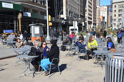
The time of year is November 15th, it is autumn, the sun is low, and tall buildings cast long shadows, sunny gaps between. Quite a lot of wind.

People are out though. Some prefer shade. Some prefer sun. All are well wrapped up against the cold....

(BTW - I've posted some video clips from this site, and from Madison Square. Got them the next day. Couldn't keep away).
These people are in the sunny area, rugged up, tables and chairs are publicly available for anyone to sit at.
The next 4 pics are all in area "A". There's a box "flatiron" cafe in the background. Sunny. Kids around. Older people too. And this last one gives you an idea of the height of that building - will be casting shadow over this square in an hour or less....


These last 3 pics are within Madison Square Park. You can see in this pic that this park is surrounded by tall buildings too...
Within the Square there are the same tables, and public open space. People choose to be in the sun, or in the shade....
Both options available in Madison Square....
Meanwhile, back in site "B", FlatIron, the sun has moved. Leaving a sliver for those searching for direct sunlight....
TV here is full of the debates. Unless there's been a terrorist act in Paris....

Public Open Spaces: NY2

This post is about Bryant Square, Manhattan, New York. Seems like New York City has been working really hard on this public space. Quite commercialised in many ways. Winter Garden seemed popular. Still lots of private/public sitting areas. Most people in shade - because sun is shaded this time of year nearly the whole time....
One thing you notice about "public spaces" in New York - and, it seems, much of the USA - there's a lot of things that you are not allowed to do. I didn't see any signs like this at FlatIron plaza, nor at Times Square (another posting). Seems like if the public space is "green" there's lot's you can't do, whereas if it's "urban" pretty much anything goes .... provided the cops are happy....
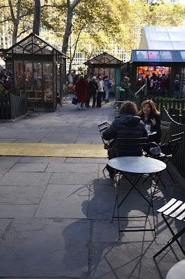
Part of Bryant Square is taken up with quite small booths that are private shops. Scarves, hats, decorative stuff mainly. Didn't notice much in the way of food being sold...

This pic gives an idea of how big the booths were. Not much bigger than a kiwi backyard glasshouse. The tables and chairs are popular private spaces in this public area...
This booth sold what looked like wall decorations in a cat outline with a wagging tail - maybe they were clocks. Haven't seen many cats with wagging tails I have to admit. Didn't see many purchased....

You do note the tree choice. Very much deciduous. Such a rational choice. Great shade in summer time. Plenty of light let through in winter time....
The centre-piece of the park is a winter garden. Skating, but more thaan that. It's a winter sit out area...the brollies proclaim the source of financial sponsorship...
This temporary atrium area overlooking the skate area was popular. Quite an interesting feature in the centre of the park....
And here's the skate area. Open to the elements. Lots more people sitting and looking rather than skating...
Just a reminder of the tall buildings surrounding Bryant Square. On all sides....
Atext
A location map...
A big part of its story...relates to the buildings that surround it....
And a wee note here - remember that Auckland's very own Queen Elizabeth Square offers great perspectives on two heritage pieces of Auckland architecture, and maybe sometime we'll be advised by the architects that Zurich and HSBC are special in some way...
All around the internal perimeter of Bryant Square (away from the booths and skate-area), are quiet area of sit and find some piece. Almost all in the shade....
This guy was hunched over his laptop watching a movie courtesy of free wifi....
The light cast here is from reflected sunlight off the windows of highrise buildings opposite. It is interesting that much of the light case during the day into these urban squares is reflected....
Groups doing their thing. Eating lunch. Having a catchup. Very relaxed and in the heart of Manhattan.
And here's where I exit Bryant Square and continue explorations of NY urban squares and plazas....

Thursday, December 24, 2015

Heritage Restoration's Hollow Ring

Devonport's Masonic Lodge. The site of much heritage angst and district scheme heritage protection controversy over plans to redevelop the historic site into luxury apartments.


Here's the development site today. Shrouded in plastic - if not in secrecy.


But wait, there's a hole in the plastic Dear Liza, Dear Liza, a hole. So I sent my little camera up for a look-see...


A void. Avoid. You can't help wondering about a heritage and historic conservation policy that allows, and does not abhor, such a vacuum. Devonport residents calmly walk past. The community runs its tongue over the teeth in its street and finds it all good. No gaps. A convenient plastic cap popped over the cavity so it all somehow feels normal. Can pretend nothing has really changed. And when the shroud is removed, the building revealed will be better than what was there, in the bone of the street, a crown no less. A gleaming shiny crown. To confirm that feeling, reinforce it. Life is good. Continues as before. All change, but no change. Not a scrap of what was there exists inside the hollow. Like a funeral without the pyre.    


There's talk of the fad of facadism in heritage - keep the facade - but remove everything behind it. But there's not even a facade here. A comment on society and what keeps us all sane and in a straight line.

A metaphor of urban neoliberalism maybe. All form and no content. All GDP and no civilisation. All economic activity for today and no long term memories of yesterday. Maybe that's what they really mean when thy speak of the post-political. But then, if that was true, no-one would've spoken out about what would be lost and what the effect would be on community with the changes to the Masonic. It's not just a building. It was a way of life. Public pubs and clubs are as much at the heart of community and civic life as are public parks and squares. And while their very existence is under threat because they are regarded as private development opportunities and because many institutions now prioritise that activity, it won't always be that way. Because people are naturally communal and have adapted over millenia to function best for the common good together. You might take the public out of the urban, but you can't take the public out of the people.


Mangawhai loses in Court of Appeal

Well I guess it's Christmas and not everything that comes in the stocking is the present we were expecting. On the 17th December 2015 Harrison, Miller and Cooper JJ delivered their decision on the various matters that had been put in front of them by the Mangawhai Ratepayers and Residents Association (MRRA) relating to the PPP EcoCare wastewater scheme.

The decision is lengthy - 69 pages - and very detailed. Much of it concentrates on Bill of Rights Act matters. Justice Miller prepared the main decision. In their follow up decisions, Cooper and Harrison generally agree with Miller's findings and decision, though their reasons are not all the same.

My summary here of the decision should not be taken as gospel, but the guts, as I see it from a couple of readings are essentially these:

  • when Parliament enacted the Local Government Act with the late addition of Protected Transactions provisions, it was to deliver the option of lower cost loans to Councils. The interest rates charged would be lower essentially in exchange for ratepayers having limited powers to challenge loans taken by their council, and therefore banks would be subject to fewer risks and costs.
  • while residents had rights to challenge these loans through judicial review, Parliament always had the power to validate loans and loan processes later, and it had the power to do that despite Bill of Rights Act provisions which grant the right of judicial review - but those rights extend to process only (council compliance with the local government act duties to consult for example), and not substantive matters (ie the loan still has to be paid).
  • Mangawhai ratepayers and residents got all the vindication they were ever going to get from the findings in the High Court judicial review that Kaipara District Council had acted against the law in whole variety of ways. There is the hint of a suggestion that MRRA might have gone further in getting its pound of flesh from the perpetrators. And there is an impression that perhaps MRRA should have pursued the Office of the Auditor General for its failings - but then the Auditor General got a prize this year didn't she - for a job well done.
  • while there were process illegalities associated with the loan, which were validated by Parliament, Parliament always intended that ratepayers should still pay for those debts, and not the taxpayer.

There were some complexities in the decision relating to the fact that MRRA' membership did not include all Mangawhai ratepayers - which raised questions about precisely which persons would materially benefit from a favourable CoA finding - and an order for costs against MRRA, I believe the above pretty much sums up the decision of Miller, and likely concludes an unfortunate example of poor local governance compounded by failures in the Audit Office and the Office of the Auditor General.

Miller has cited speeches from Hansard given by Phil Twyford (for Labour) and Eugenie Sage (for the Greens) in respect to an effort by Andrew Williams (for NZ First), to explicitly exclude from the Validation Bill, provisions in respect to the outstanding debt. William's efforts did not attract the support needed in Parliament, suggesting - without really nailing it - that Parliament always intended that ratepayers would have to carry the can for their council's decisions - and that nobody else would. That is one interpretation of what Parliament did. I don't think Parliament - in respect of individual MPs - explicitly accepted that what they were doing with the validation bill was washing their hands of every aspect of this institutional failure.

I wrote some time ago about the law being an ass in respect of what happened at Mangawhai. Unsure now.

Expert, Social engineer, Critical Expert or Smuggler?

AESOP's BEST PUBLISHED PAPER AWARD 2015 goes to Mee Kam Ng for the paper: Intellectuals and the Production of Space in the Urban Renewal Process in Hong Kong and Taipei published in Planning Theory and Practice, 2014, 15(1) 77-92.

I came across it last week while I was doing a bit of research.

The abstract grabbed my attention:

Through two concrete urban renewal cases in Asia, this paper develops a schema of “social engineers-smugglers-experts-critical experts” to differentiate the roles of system-maintaining and system-transforming intellectuals in the production of space. While pro-establishment “social engineers” and “experts” use their “epistemic authority” to produce top-down renewal plans to promote exchange values, “critical experts” outside the government and “smugglers” within the bureaucracy play significant roles in “de-coding” the use values of people’s lived spaces. The cases highlight the important roles of system-transforming intellectuals in reproblematizing urban renewal issues and experimenting with alternative policies and plans to restructure space that sustains community building.

A bit of a mouthful - but it's Christmas, it's tasty, chew well. You can always spit it out. But you might just swallow it. Another extract:

The two case studies to be discussed in this paper highlight the roles of “intellectuals” in the course of spatial restructuring in the two cities. In Taipei, if it were not for the advocacy of students and professors from the National Taiwan University (NTU), the Organization of Urban Res (OURs) (a civil society organization), and the “progressive bureaucrats” in the newly established Cultural Affairs Bureau (CAB), the squatter settlements in Treasure Hill would have been demolished to make way for a park. Similarly in Hong Kong, were it not for the educated social activists and “artivists” in the community and “enlightened” individuals within the Urban Renewal Authority (URA), the 150-year old market streets in Graham and Peel Street would have disappeared with the redevelopment of the surrounding buildings. This paper aims to examine the roles of these “intellectuals” in the production of space in these two cases.

The author presents this straight-forward tabulation:


Here is an extract from the conclusion:
The two stories accentuate the importance of the system-transforming intellectuals in exercising their conscience and capacity to utilize and synthesize personified knowledge. In both cases, the local communities did not really object to the government-led abstract plans. Hence, the intellectuals could easily side with those in power, rationalizing their decisions to erase the two communities. However, the system-transforming “critical experts” in both cities, following the time-honoured tradition of Chinese intellectuals, chose to speak truth to their counterparts in the established system to conserve something that they believed to be important for the future of the two cities. These “critical experts” are of crucial importance in highlighting the essence and meaning of the two settlements, allowing their lived spaces to be appreciated by the wider community and hence succeeding in “re-problematizing” and “re-writing” the storylines. Coupled with “smugglers” within the bureaucracy, different cityscapes were produced. 
However, there is no place for complacency in the two cases. Whether the Graham and Peel Street Market in Hong Kong will survive the phased redevelopment is still unknown and, in the face of competition with global cities, especially those on the China mainland, neo-liberalism has overtaken idealism as one of the main policy concerns in Taipei (Huang and Hsu, 2011). Nevertheless, the two stories appeal to “intellectuals” especially those in Asia, emphasizing the importance of their continuous vigilance in counteracting renewal plans made in the thick of neoliberal rhetoric to promote economic growth and city competitiveness. This can be done through thorough understanding, analysing and documenting the use values of people’s lived spaces and reviewing the inadequacies of top-down plans made by “social engineers” – so that, given the opportunities and the inside activism of “smugglers”, alternative renewal plans and processes can be formulated, experimented with and revised continuously, to speak to the daily needs of local communities – creating soul-nourishing spaces and urban forms.
Because it has won the AESOP award the paper has been made publicly available.
You can download it here. What sort of intellectual are you in the work that you do?

Thursday, December 3, 2015

Better Auckland Pedestrian Comfort Assessment

In the quote below, (from a best practice report prepared recently for Melbourne) imagine that "Auckland" is substituted in place of "Melbourne" in this text:
In the light of urban growth, Melbourne needs to address the rising numbers of pedestrians in the central city. Walking is the main mode of transport (86%, figure 12, p. 10) and tram stops, pedestrian crossings and sidewalks get increasingly crowded at peak hours. The principal aim of the new pedestrian strategy, conducted by City of Melbourne’s strategic transport planners, is to get people to walk more by providing a suitable urban environment to walk in – a street network capable of facilitating current as well as future levels of pedestrians. This research looks at pedestrian crowding, and how it is measured and analysed in cities around the world. It reviews two specific tools, pedestrian level of service (LOS) and pedestrian trip generation. It studies London, New York and Copenhagen in more detail, and the work and experience of Gehl Architects in Copenhagen.  
It commences a discussion of how these methodologies are relevant to Melbourne and whether they are applicable and/or can form inspiration in the development of Melbourne’s pedestrian analysis. The study has found that although many cities work to improve pedestrian conditions, there is no generally adopted methodology or standard for pedestrian LOS or trip generation. Pedestrian trip generation calculations are novel and relatively unexplored....  
A majority of cities analysing pedestrian LOS use the Fruin scale from the 1970s. This method analyses quantitatively the number of people walking in a street, but ignores several important factors relating to walkability. Gehl Architects has led the way in elaborating a different and more comprehensive methodology, based on over 30 years experience. They have identified a general street crowding capacity of 13 people per meter per minute, a figure applied by London in their Pedestrian Comfort Level (PCL) assessments. The London framework combines Fruin’s crowding scale with Gehl’s experiences and sets up a comprehensive implementation guide based on area types, street features and pedestrian counts. PCL is calculated for both sidewalks and pedestrian crossings. Melbourne could implement this framework directly, if more and better counting sensors are installed, data collected from the relevant sites and area types analysed in terms of crowding acceptance.....
I've already posted information here and here about what Dr John Fruin has to say in the 1970's about the safe capacity of a pedestrian corridor or laneway. This is a summary of Gehl's more recent findings:

Gehl Architects have assessed walkability in cities all around the world, including Melbourne. Gehl defines crowding as more than 13 people per minute per meter footway width. This is based on long experience. The Architecture School in Copenhagen collected data in public spaces in Copenhagen between 1968 and 1996. They found through this research that the main pedestrian street, Stroget, in Copenhagen reached its capacity at 13 people per meter per minute. Once this level of activity was reached, pedestrians started to move along parallel streets to avoid congestion. 
Recommended pedestrian capacity:
13 person/minute/meter footway width x available footway width = no. of pedestrians/minute 
Henritte Vamberg at Gehl Architects says: ‘The comfort level drops the more pedestrians you have. The above parameter is looking at when pedestrians start walking in “lines”, when you get crushed, when you can’t maneuver a wheelchair through etc.’. What is different with this methodology is that it is based on levels of quality and comfort rather than quantity – conventional LOS methods (mentioned by Fruin) deal only with how many people a street can carry (Gehl Architects, 2004, p. 34).

Using the Gehl walkability metric for a 5 metre wide laneway:  13 x 5 x 60 = 3,900 pedestrians/hour.

This is a conservative - perhaps Scandanavian - approach. The Pedestrian Guidance Manual for London takes Gehl and Fruin and observations to produce a set of guidelines related to Pedestrian Comfort Levels in London. It contains two useful graphics, and ppmm (pedestrian per metre width per minute) advice, which are applicable to office, retail and mass transit pathways.....


Taking the "D" Pedestrian Comfort Level established by London Transport (assume 30 people/clear pathway width metre/minute), and applying it to the proposed downtown laneway, what carrying capacity does a 5 metre pathway have - at this "Very Uncomfortable" service level?

Carrying capacity = 30 x 5 x 60 = 9,000 people/hour

Which is less than the 10,000 average capacity claimed by Auckland Council, and much less than the peak capacity claimed in evidence to hearing commissioners of 16,000 people/hour, and makes a mockery of the 24,000 people/hour claimed by Auckland Council in further information provided to commissioners.

The London advice provides a useful tabulation of pedestrian comfort levels for different types of pedestrian environments, including mass transit pathways. This relates to the A to E comfort level carrying capacities tabulated above.


You can see there that London Transport's advice is that a service level of C+ to C is deemed "acceptable" and that planning for higher throughput means that pedestrian comfort is assessed as "at risk".

Using the "C" grade of personal comfort, gives the carrying capacity of a 5 metre wide laneway as:

23 x 5 x 60 = 6,900 pedestrians/hour

If Auckland wants to build toward its claim as "most liveable city", surely it is about time it adopted pedestrian comfort standards that are recommended in other great cities.


Gehl Architects, 2004, ‘Towards a Fine City for People – Public Spaces and Public Life – London 2004’, DM 7460245

Friday, November 27, 2015

Auckland's Failing Climate of Democracy

There are all sorts of definitions of democracy. For example, "the ​belief in ​freedom and ​equality between ​people, or a ​system of ​government ​based on this ​belief, in which ​power is either ​held by ​elected ​representatives or ​directly by the ​people themselves..."
Many definitions suggest that a characteristic of democracy is: "freedom of speech and press...."

Twenty or more years ago, before debates about climate change had overtaken discussions about democracy, much of the discussion about what democracy was and how it manifest at local level, concentrated on the idea of the climate of democracy. Which is a way of thinking about the civic culture that exists in a community - how it develops and what fosters it - so that the community is predisposed toward, or educated to accept and expect, democratic processes and political activities in public life. This idea is that democracy cannot be imposed by laws or treated as a social add-on. That it is built into society and its institutions and becomes a conscious and maintained state of mind of the people.

Some western democracies build it into the school curriculum, so that students leave school with a grounding in civics and an understanding of politics and that it is normal for people to hold different values from each other requiring processes, negotiation and understanding to reach jointly agreed decisions.

I accept that not everybody wants to involve themselves in public minded activities and processes. Life's too short, they might say, and prefer to concentrate on their own individual pursuits and objectives. It has always been thus. But I think we have seen a number of structural changes in Auckland that are causing its climate of democracy to fail putting at risk its ability to act for the common good, in the public interest, whatever that might be.

When I was first in local government - councillor on North Shore City Council, board member on Devonport Community Board - I gradually came to understand how local democracy functioned here, and the role it performed in maintaining the local climate of democracy. Most meetings were attended by reporters from the North Shore Times Advertiser (NSTA). Local issues were extensively reported. Councillors were named and shamed. I remember how anxious councillors would become on NSTA publication days. They wanted to see how they'd been quoted, what angle the reporters had taken. And these newspapers were very widely read, but often not by the section of the community busy with their own lives and objectives. The impression I gained was that the avid readers of the NSTA were the ones who voted in the local elections at least, and were often the "go to" people in the community for others wanted some guidance on who to vote for.

School projects focused on local issues that became hot topics: sewage on beaches, cycle lanes, public transport, recycling, water demand statistics. Students would phone councillors. Take clippings from the NSTA. Debate the issues with their parents. All of these activities fostered what I'll call North Shore's climate of democracy.

And this is what we are losing. Local government amalgamation, centralisation and corporatisation has pretty well gutted local communities of the nucleus of local democracy. The same issues exist, but without that institutional focus, local communities are disempowered and their ability to make a difference reduced. The NSTA still exists but its utility is diminished by the loss of local government purpose. Many resort to individualism which is understandeable, but given we are a species that has adapted to working successfully in groups, we are unlikely to be as successful as we could be working more collectively on shared problems.

It is interesting to reflect that free speech and a free press is seen by many as an essential component of a thriving democracy. It is OK to walk down to your front gate and voice your concern for all to hear who open their front doors to listen. Previously you could go to community forums and vent your spleen, get a few nods of agreement, and if there was merit maybe even lead a change. Increasingly individuals resort to facebook (or even a blog) to express themselves.

Which brings me to the role of a free press in a democracy. Newspapers of record - that reported most of the important decisions or issues of the day - form an essential part of the body politic of a local democracy. Reports, opinions, think-pieces, investigative journalism, letters. All of these components would be contained within those pages. Not friends sharing with like-minded friends, but a diversity of views and ideas and stories and articles. It is the range and breadth that we will lose in Auckland as NZ Herald quietly divests itself of writers and reporters, and as the pages of the newspaper shrink in content and devolve into an expanded stuff.co.nz.

That's why I think Auckland's climate of democracy is failing. And it will need to improve to develop the sort of conscious and engaged communities that will be a pre-requisite to an educated, engaged and organised response to atmospheric climate change on the one hand, and to changes in urban form on the other.

Sunday, November 22, 2015

Another Council Consent Processing Error

Is Council's policy of non-notification leading to future budget blow-outs at best, or future bus commuter health and safety hazards at worst...?

There's been a couple of recent hearings relating to the Precinct Properties and Auckland Council PPP in downtown Auckland (The one with the new tower, proposed partial Queen Elizabeth Square sale, CRL enabling works, and shifting a bus terminal from Lower Queen Street to Lower Albert Street). The first was a hearing of objections to Auckland Transport's proposal to "stop" the road status of the part of the Queen Elizabeth Square proposed for sale, and the second was Precinct Properties private plan change 79 to change the zoning of the part of the Queen Elizabeth Square proposed for sale from public open space to zoning more conducive to private development. The latter hearing was covered by Bob Dey here, here and here.

One of the issues many submitters raised at the hearing related to laneway width proposals worked out and modelled by Precinct Properties working with Auckland Transport. I posted about this issue here. This demonstrates that using Fruin's formulae (Fruin is the acknowledged expert) and his approach to modelling commuter pedestrian flows in corridors, that to safely move an average of 10,000 people per hour, the corridor needs to be between 8.3 and 8.9 metres wide, when the corridor is lined with shops.

This is Precinct's architectural rendering of the proposed east west laneway - a narrow 6 metres wide and connecting Lower Queen Street with Lower Albert Street. The section of the laneway (proposed to be available 7/24) from Lower Albert Street to the current western edge of Queen Elizabeth Square is about 60 metres long. It is intersected with a small dog leg lane running north to south (which is not 7/24), and, as the image shows, is lined with various retail outlets.

What I have discovered since the hearing is that Auckland Transport must have been using the same Fruin formulae when it did the modelling with Precinct Properties, but it came up with a figure of 6.5 metres based on a "conservative" flow rate peaking at 16,000/hour. Interestingly, Fruin suggests that an average of 10,000 per hour would include a peak flow, which he suggests would mean that 40% of the 10,000 might go through the corridor in just 15 minutes. For those of you mathematically minded, this means you have to do a sum where you divide 0.4 by 0.25 (40% of the pax in a a quarter of the time), giving a multiplier of 1.6. This ratio, x 10,000, gives 16,000, the "conservative" rate. But in this case Fruin carefully distinguishes between moving pedestrians through a corridor without colonnades, shop fronts, and side entry-ways - from a corridor (or laneway) that is lined with shop fronts etc.

I believe that Precinct Properties have been mis-advised by Auckland Transport. The proposed 5 metre wide (or 6.5 metre wide - with 0.75 metres on either side of a "free" 5 metre wide passageway), will not be wide enough to safely allow the passage of 10,000 pedestrians per hour through its shop-lined laneway (which is really just an arcade - laneways are quaint, open to the sky, cobbled, crooked....).

Which raises several interesting questions.

The Plan Change 79 hearing ONLY relates to the bit of laneway that would be built through the part of Queen Elizabeth Square that is proposed for sale. A section about 40 metres long. The other section, the 60 metre section, has ALREADY been consented in June this year. At that time a non-notified consent was granted for this 60 metre section of 5 metre / 6.5 metre laneway. Which, as I've explained, according to the experts, will not safely allow the passage of 10,000 pedestrians per hour.

I surmise that because the June hearing was non-notified, and because there were no submissions about the laneway, then the particular matter of corridor width was not an issue for the commissioner considering the application. I am not aware of what evidence or information was available to the commissioner at that hearing supporting the application for a 5 metre/6.5 metre wide mass transit access corridor. What can you do with a permit that allows a public pedestrian hazard to be constructed?

One of the reasons officers would have used to justify non-notification of Precinct's June application would have been that it was largely based on the previous consent obtained by Westfield for the tower and mall redevelopment (which is examined here and here), and which was purchased by Precinct Properties when it purchased Westfield's interests in the downtown site.

However the situation and context had changed from when Westfield obtained its permits because more detailed information existed related to proposals to shift the entire Lower Queen Street bus terminal into Lower Albert Street. This information better quantified the impact or requirement of the proposed laneway serving as a critical link in Auckland's CBD passenger transport terminus and interchange. However it seems to have had no impact or effect on the laneway plan. Which is now consented. What a cockup.

This awkward and poorly planned situation closely resembles, and was influenced by, what happened when Westfield applied for consent for its tower and mall redevelopment in the first place. At the time ARTA (Auckland's then Passenger Transport Planning Agency), raised concerns that the basement parking and foundations of the proposed tower would interfere with the proposed Central Rail Link tunnel. However Auckland City Council ruled that ARTA had no standing because it could not designate the route. ARTA was not even able to make formal submissions relating to proposals to put bus interchange facilities in Lower Albert Street. Auckland City Council proceeded with the application on a non-notified basis.

This has subsequently meant that Auckland Council was forced to pay through the nose compensating Precinct when it finally got round to designating the CRL route. It also meant, because ARTA was not able to be properly involved, that the matter of the safe laneway width was not dealt with at that time either.

Looks like the CRL compensation history might repeat. This time, because Precinct Properties has been permitted to build a narrow and unsafe laneway, Auckland Council and Auckland Transport will have to figure out and pay for an alternative that allows public transport passengers to interchange modes and to directly access their destinations. Or maybe they'll just do nothing. Auckland CBD public transport passengers will have to put up with poor planning and figure out alternative, safer and less congested routes. Or maybe they'll just close the laneway if it looks like too many people are using public transport.

And by the way, the 10,000/hour commuter pedestrian flow figure is not a lot different from today's patronage data. Shouldn't we be planning public accessway infrastructure capacity that will meet the needs of a growing city population, with an increasing public transport mode share?

And all because significant applications are not being publicly notified.

Monday, November 16, 2015

Understanding PPPs: NY Workshop on Public Space


I write this brief report in New York. I was invited to attend this International Workshop because of my university research on public space planning on Auckland and Wellington waterfront land. The workshop was attended by academic and expert geographers, anthropologists and urban planners from France, Austria, USA and New Zealand (moi).

Title: Understanding Public Private Partnerships: governance, urban development and spatial justice. Held at City University of New York at the CIRHUS - Center for International Research in the Humanities and Social Sciences, sponsored by CUNY-CPCP and Metropolitics/Métropolitiques.

The intro to the workshop reads: "As cities have adopted the entrepreneurial turn (Harvey, 1989), many urban interventions initiated or encouraged by public authorities rely on the financial capacity and the know-how of both for-profit and not-for-profit private interests to (re)develop land. Presentations will examine public-private partnerships that contribute to the development of ostensibly public space, the creation of urban amenities as well as the formulation of urban design aesthetics and production of architectural quality..."

Professor Elliott Sclar was the discussant. The morning was allocated to a series of 15 minute presentations (very tightly managed!), then discussion. After lunch a smaller group concentrated on the mechanics of producing a journal issue on the workshop. The presentations were attended by a much wider group of academics and practitioners.

I won't go into detail here, but just a few highlights. Phil Berge-Liberman from University of Connecticut kicked off talking about "Conservancy Park" planning where private investment in parks maintenance and development increasingly gives the investors the right to determine "proper use" of the park, and to introduce ideas like "the landscape has rights too". He described in detail the amount of private money that now goes into New York's Central Park - with ideas like "adopt a tree" and suchlike to the extent that investment now shapes the way it is used. Large "political" gatherings are much less likely. Many behaviours are prohibited. He produced statistics that showed in 2009 the park added $17.7 billion in value to properties adjacent to the park. One throw away line he used, "the difference between parks in working class neighbourhoods and wealthy ones, is that the first are brown - because they are used so much for football and basketball, and the others have much greater tree canopy and green - because they are hardly used at all by comparison.

Yvonne Franz from Austrian Academy of Sciences spoke about residential PPPs in Vienna, what she described as "social democratic city", operating in compliance with the "EU Stability and Growth Pact" - which she didn't really explain, but sounds similar to what's happening in NZ, where Central Government imposes its growth targets on Auckland Council and Auckland. Apparently Vienna (which is not a big city) is building 8,000 to 10,000 new apartments per year. Her concern was the fact that private investor is not interested in schools or kindergartens. She described it as "single project thinking". Lack of integrated planning. She described "under-utilized open space semi-private park spaces". Her concern was that this results in "limited sharing practices", and for connecting. Her work suggests there needs to be thinking and design about "interaction between generations" - to "create social mixing amongst new and existing residents". What also struck me about Yvonne's talk was that the carrot of "affordable housing" is used to get political and public sign-off of PPP residential projects, but there is little effort put into ensuring those numbers get delivered and are protected. (Invokes in me the thought of how often in Auckland the carrot on the waterfront is public space - and how frequently it is either not delivered, or that it is taken away and privatised).

I compared public space outcomes at Auckland and Wellington - under the same statutory environment, yet so very different in quality - and provided an analysis of the reasons for those differences. And finished with an account of what is happening now in downtown Auckland. The risk that public space will be appropriated in the interests of the deal that has been reached between Auckland Council and Precinct Properties unless third sector groups like Auckland Architecture Association, Civic Trust and Urban Auckland intervene in the public interest. This sparked response from visitors. Sclar suggested their action might be subversive. Another commented, "same as here, can't see daylight between the interests of municipalities and developers. Calls into question what you call public..."

You get the picture. I was among fellow travellers. Other interesting presentations followed. Lots of ideas shared. Will share more in the blog later.


New York Highline Park

My hotel in NY - "Hotel 309" - great location, slightly strange - was very close to the Highline Park. One of NY's most recent parks. Made from a dis-used, elevated railway line. Very interesting. Tourist attraction. Cause celebre. Made me think - for some strange reason - of the Otago Rail Trail. Both projects have had massive economic development effects. More later....

BTW - if love is the answer, what is the question? Or maybe, love is the answer to every question. Is that the theory?

Lovely place to walk....


I was in West 14th, very near the MeatPacking District. Very trendy it seems.
The Highline goes through all the original railway buildings....
And across streets and avenues. Here's a group being given a story about it. Many tour groups along the line. If you click the pic you'll be able to read the yellow sign - and understand a pic that's coming...
One of the streets you look down on...
...here's the motivation for that yellow sign... stacked car-parking...(I see that underground parking back of my hotel is about $60US for 24 hours. And lots for an hour or two...

Back to the Highline. Trees and grasses and all sorts are planted along the way. Delightful....
We learned at the workshop that property values along the Highline have gone through the roof. The gentrifying effect of this sort of parks infrastructure. Just half a kilometre away is the Hudson River Park. Built in the 1970's instead of a proposed motorway that was planned for the whole of West Manhattan. Largely working-class residents built a huge campaign. Stopped the motorway. Got a riverside linear park instead and a smaller arterial. Again - land become so expensive, developers moved in, and pushed the old communities out that had so successfully campaigned against the motorway....
All along the route, you can see for-sale and to-let signs. Changing fast.
People are changing their backyards to inter-relate with the Highline. Something they turned their backs on, has become the main attraction.
And every now and then a reminder of what was there. A railway line...
Here's another group of tourists getting the story. A popular destination. With many access points, lifts and stairs, and great places nearby to eat and drink...

Just wanted to share this with you. This sign is at every entry to the Highline Linear Park. Quite exhausting and depressing to wade through. And very American. Reminded me of those immigration forms you had to sign you'd not recently been guilty of "moral turpitude". Maybe that's why I never saw an American on the grass in a park - not prohibited though!

Public Open Spaces: NY1

In this part of Manhattan, New York, there are 3 public spaces. The big one - "C" - is Madison Square Park. There's a couple of pics further down - but I was mainly interested in the other urban spaces....

The first pic - below - is from "A", looking across E23rd toward "B".

The time of year is November 15th, it is autumn, the sun is low, and tall buildings cast long shadows, sunny gaps between. Quite a lot of wind.

People are out though. Some prefer shade. Some prefer sun. All are well wrapped up against the cold....

(BTW - I've posted some video clips from this site, and from Madison Square. Got them the next day. Couldn't keep away).
These people are in the sunny area, rugged up, tables and chairs are publicly available for anyone to sit at.
The next 4 pics are all in area "A". There's a box "flatiron" cafe in the background. Sunny. Kids around. Older people too. And this last one gives you an idea of the height of that building - will be casting shadow over this square in an hour or less....


These last 3 pics are within Madison Square Park. You can see in this pic that this park is surrounded by tall buildings too...
Within the Square there are the same tables, and public open space. People choose to be in the sun, or in the shade....
Both options available in Madison Square....
Meanwhile, back in site "B", FlatIron, the sun has moved. Leaving a sliver for those searching for direct sunlight....
TV here is full of the debates. Unless there's been a terrorist act in Paris....

Public Open Spaces: NY2

This post is about Bryant Square, Manhattan, New York. Seems like New York City has been working really hard on this public space. Quite commercialised in many ways. Winter Garden seemed popular. Still lots of private/public sitting areas. Most people in shade - because sun is shaded this time of year nearly the whole time....
One thing you notice about "public spaces" in New York - and, it seems, much of the USA - there's a lot of things that you are not allowed to do. I didn't see any signs like this at FlatIron plaza, nor at Times Square (another posting). Seems like if the public space is "green" there's lot's you can't do, whereas if it's "urban" pretty much anything goes .... provided the cops are happy....
Part of Bryant Square is taken up with quite small booths that are private shops. Scarves, hats, decorative stuff mainly. Didn't notice much in the way of food being sold...

This pic gives an idea of how big the booths were. Not much bigger than a kiwi backyard glasshouse. The tables and chairs are popular private spaces in this public area...
This booth sold what looked like wall decorations in a cat outline with a wagging tail - maybe they were clocks. Haven't seen many cats with wagging tails I have to admit. Didn't see many purchased....

You do note the tree choice. Very much deciduous. Such a rational choice. Great shade in summer time. Plenty of light let through in winter time....
The centre-piece of the park is a winter garden. Skating, but more thaan that. It's a winter sit out area...the brollies proclaim the source of financial sponsorship...
This temporary atrium area overlooking the skate area was popular. Quite an interesting feature in the centre of the park....
And here's the skate area. Open to the elements. Lots more people sitting and looking rather than skating...
Just a reminder of the tall buildings surrounding Bryant Square. On all sides....
Atext
A location map...
A big part of its story...relates to the buildings that surround it....
And a wee note here - remember that Auckland's very own Queen Elizabeth Square offers great perspectives on two heritage pieces of Auckland architecture, and maybe sometime we'll be advised by the architects that Zurich and HSBC are special in some way...
All around the internal perimeter of Bryant Square (away from the booths and skate-area), are quiet area of sit and find some piece. Almost all in the shade....
This guy was hunched over his laptop watching a movie courtesy of free wifi....
The light cast here is from reflected sunlight off the windows of highrise buildings opposite. It is interesting that much of the light case during the day into these urban squares is reflected....
Groups doing their thing. Eating lunch. Having a catchup. Very relaxed and in the heart of Manhattan.
And here's where I exit Bryant Square and continue explorations of NY urban squares and plazas....